Above: The map shows the locations of some of the larger wildfires currently burning in Tennessee, South Carolina, North Carolina, and Georgia.
Firefighters continue to battle dozens of fires in the southern United States while the residents in the area try to figure out how to live with the smoke.
Fire managers are hoping for a break in the weeks-long dry period, but through Friday at least they should expect more of the same. However there is a chance for rain on Saturday.
Here we will look at six of the larger fires in Georgia, North Carolina, and South Carolina.
Party Rock Fire

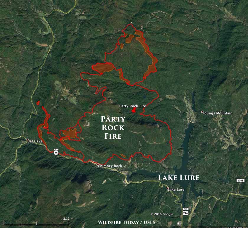
The Party Rock Fire has been burning just north of Lake Lure, North Carolina since November 5. It has blackened 4,480 acres, an increase of 736 acres, and forced evacuations at Bat Cave and residences on the east side of Hwy 9. In recent days it has been most active on the north and southwest sides.
Rock Mountain Fire

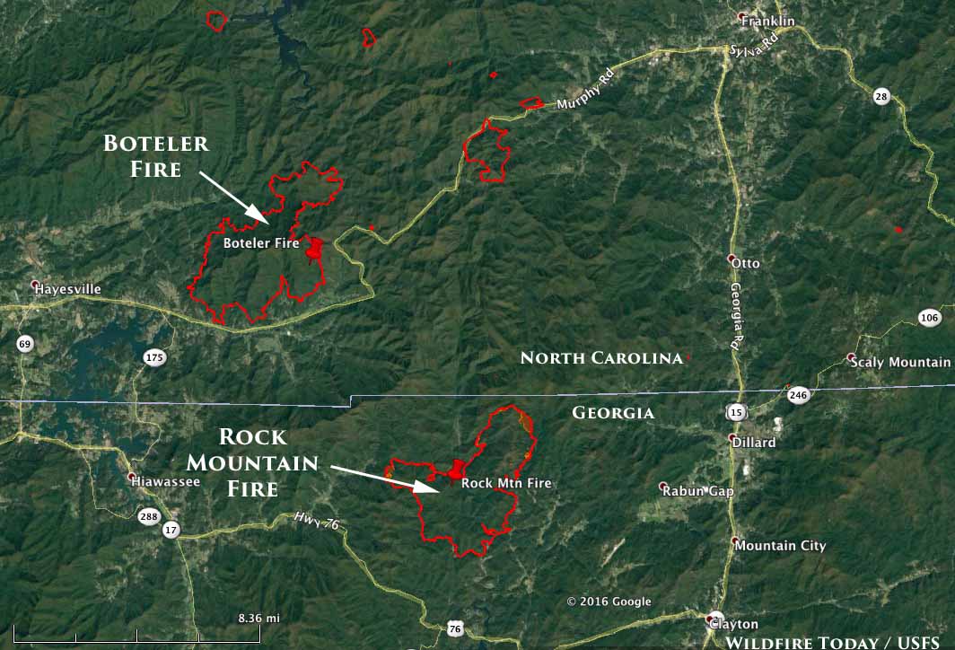
The Rock Mountain Fire has burned 6,747 acres in the northeast corner of Georgia, an increase of 1,263 acres over the previous 24 hours primarily on the northeast and west sides. The Type 1 Incident Management Team reports that 75 structures are threatened, but none have been destroyed.
Boteler Fire
(See the map above)
The spread of the 8,967 Boteler Fire in the southwest corner of North Carolina has slowed considerably in recent days, only increasing by 42 acres according to the last report. Fire managers said 197 structures remain threatened, while none have been destroyed.
Chestnut Knob Fire

The Chestnut Knob fire has burned 4,600 acres seven miles southeast of Morganton, North Carolina. On Tuesday it was more active than earlier this week, with longer flame lengths, uphill runs, flanking, and some spotting. Firefighters have been working on removing fuel along Rich Mountain Road by strategic burning.
Pinnacle Mountain Fire

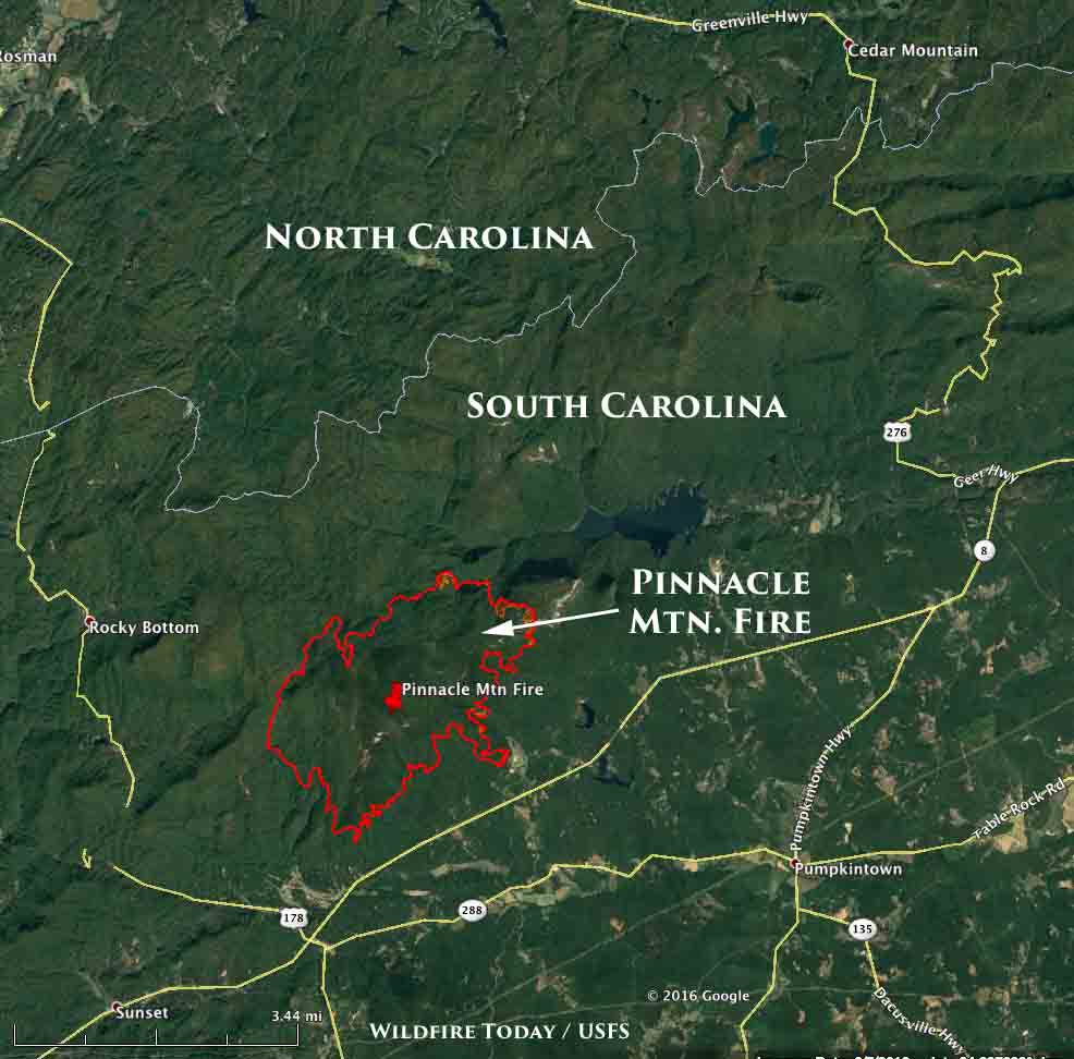
The Pinnacle Mountain Fire has burned 2,765 acres 10 miles north of Picken, South Carolina, an increase of 452 acres over the previous mapping. The fire is being driven by steep topography and currently threatens 700 structures. Fire managers are planning a large burnout for Thursday. National Guard helicopters have been assisting firefighters on the ground by dropping water.
Smoke created by the fires
For the latest articles at Wildfire Today about how smoke from the wildfires is affecting various locations in the South, check out the articles tagged “smoke”.


Yes 40 is open. We are seeing a lot of smoke here in Knoxville. Somedays it’s so thick it slows traffic.
Is hwy 40 east from Knoxville Tennessee to Greensboro n.c open for travel
I-40 is open! Just last night (Thurs 11/17), my husband and I drove from Tennessee through Greensboro (and then some) via I-40.
That said, you might experience a noticeable air quality decrease near Asheville, largely originating from the nearby Party Rock fire.
Also, FYI If you have any upcoming outdoor plans in NC right now: some unrelated NC state parks are closed “in order for staff to assist other state parks with wildfires”, so please be sure to check before you visit.
P.S. If you wonder about the Party Rock fire, long story short: it’s located OFF of I-40, down the Bat Cave / Lake Lure exit, where some locals are evacuated and there’s a huge detour.
Longer version of that story:
“US 74A/US 64/NC 9 is closed from near Lake Lure town hall through Chimney Rock to Bat Cave.” For Detour: “Traffic traveling US 64 West take NC 9 south to NC 108 west to US 74 west to I-26 west to US 64 east. For traffic traveling US 64 East, use US 64 west to I-26 South to US 74 East to NC 108 north to NC 9 north to US 64.”
Also, if you happen to be in Asheville on Saturday (11/19) and see some increased traffic heading toward the Chimney Rock Village direction, please don’t follow unless you’re a local with a re-entry pass! Still no visitors and through-traffic allowed (and police checkpoints will keep it that way).