Multiple wildfires burning in Colorado

map colorado fires

Above: Colorado Fires. Heat detected at 1:01 p.m. MDT June 30, 2018.

(UPDATED at 6:11 p.m. MDT June 30, 2018)

Colorado has been the location where much of the firefighting action has taken place during the last couple of weeks and that continues as at least five large blazes burn across the state.

The map above shows the locations of the largest and most active fires. The heat data on the map is from 1:01 p.m.  MDT June 30.

Here is the list:

  • 416 Fire, 9 miles north of Durango. 47,000 acres. It started June 1.
  • Spring Creek Fire, between La Veta and Fort Garland along Highway 160. 38,000 acres. CDOT reports that the closure of US 160 between Fort Garland and La Veta and the closure of CO 12 between Cuchara and La Veta, will continue. The fire is now pretty well established on the north sides of Highway 160 and Mt. Maestas. (More information.)
  • Chateau Fire, 7 miles northwest of Cripple Creek. Our VERY UNOFFICIAL estimate puts it at 1,300 acres early Saturday afternoon. (More information)
  • Weston Pass Fire, 16 miles southeast of Leadville. Our VERY UNOFFICIAL estimate puts it at 3,400 acres early Saturday afternoon. US 285, in Park County, is closed between Fairplay and Antero Junction (mp 188 to mp 163) in both directions. A Type 1 Incident Management Team has been ordered and will assume command  7/1. This team will manage both the Weston Pass Fire and the High Chateau Fire. (More information)
  • Sugarloaf Fire, 13 miles northeast of Silverthorne. The Forest Service estimates it has burned about 1,300 acres. This fire is not being fully suppressed.
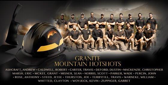
Granite Mountain Hotshots — five years ago today

Granite Mountain HotshotsWhen I think about the June 30, 2013 tragedy where 19 firefighters were killed battling a fire near Yarnell, Arizona, I remember Abraham Lincoln’s Address as he and others dedicated a military cemetery in Gettysburg, Pennsylvania, where thousands of soldiers died almost exactly 155 years ago, July 1-3, 1863, in what has been described as the turning point of the Civil War. We don’t even know for sure the number killed, with estimates ranging from 7,000 to 8,000.

The President was honoring those who were killed in the battle. The men fought each other, the North vs. the South. Wildland firefighters, thankfully, don’t fight each other, but there are similarities between fighting wars and fighting wildfires.

That day in 1863 the President said in part:

“…It is rather for us to be here dedicated to the great task remaining before us—that from these honored dead we take increased devotion to that cause for which they gave the last full measure of devotion—that we here highly resolve that these dead shall not have died in vain.”

It is difficult to find positive outcomes in a mass casualty incident like the Yarnell Hill Fire. But one thing that is doable, is to at least learn some lessons, and more importantly, use them to take action to reduce the number of fatalities on wildland fires. We will never eliminate all risks of firefighting, but proactive management locally, at the national level within the agencies, and in Congress, can make a difference.

Excerpt from Lincoln’s Gettysburg Address:


“…Now we are engaged in a great civil war, testing whether that nation, or any nation so conceived and so dedicated, can long endure. We are met on a great battle-field of that war. We have come to dedicate a portion of that field, as a final resting place for those who here gave their lives that that nation might live. It is altogether fitting and proper that we should do this.

“But, in a larger sense, we can not dedicate—we can not consecrate—we can not hallow—this ground. The brave men, living and dead, who struggled here, have consecrated it, far above our poor power to add or detract. The world will little note, nor long remember what we say here, but it can never forget what they did here. It is for us the living, rather, to be dedicated here to the unfinished work which they who fought here have thus far so nobly advanced. It is rather for us to be here dedicated to the great task remaining before us—that from these honored dead we take increased devotion to that cause for which they gave the last full measure of devotion—that we here highly resolve that these dead shall not have died in vain—that this nation, under God, shall have a new birth of freedom—and that government of the people, by the people, for the people, shall not perish from the earth.”

Elevated fire danger in the Southwest today

Minimum relative humidities predicted for Saturday

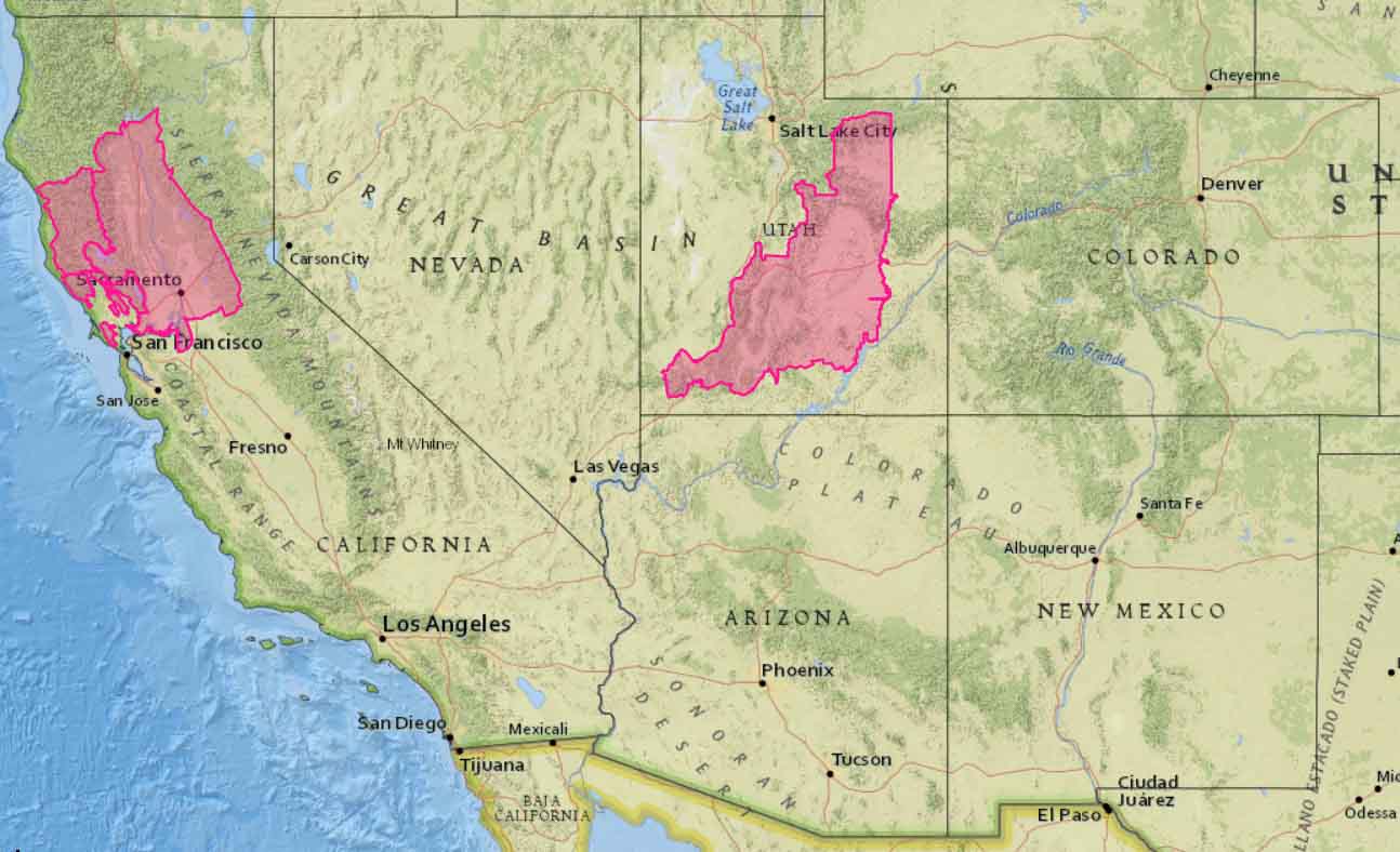
Above: map showing minimum relative humidity levels predicted for Saturday in the Western United States. Red Flag Warning areas are in Utah and Northern California. NWS.

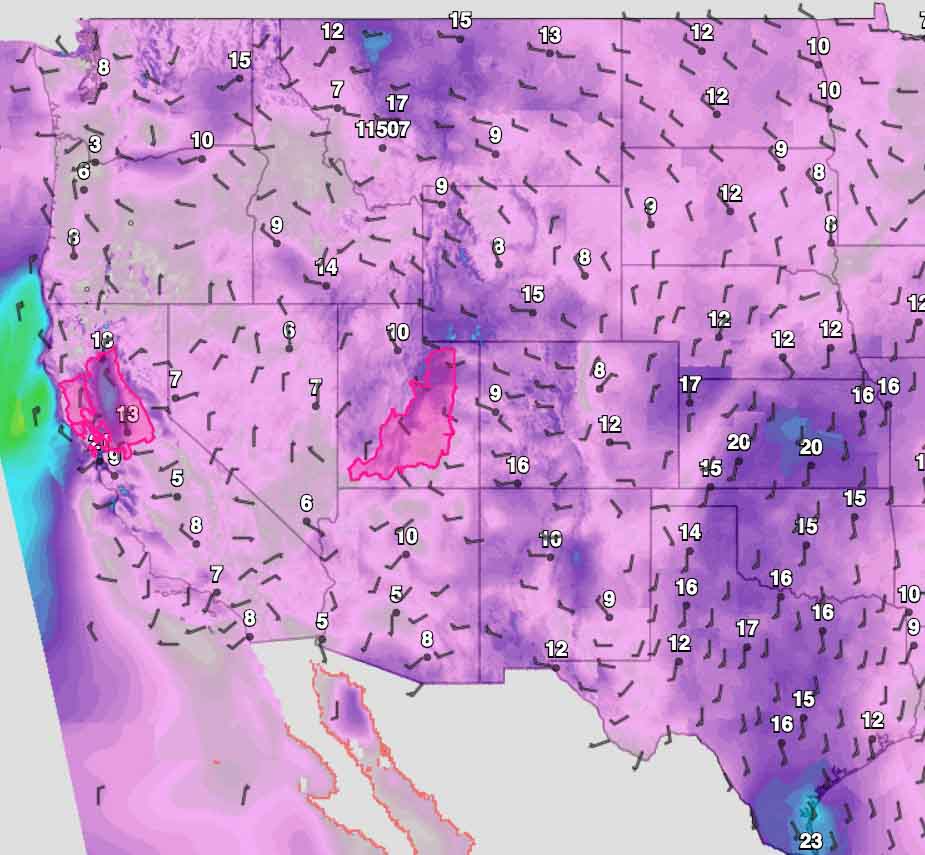
The official Red Flag Warnings for Saturday only include portions of Utah and Northern California, but low humidities will be prevalent across most of the southwest one-quarter of the country. Generally, the winds will not be especially strong, which is probably what kept the Red Flag Warning areas from being larger than they are.

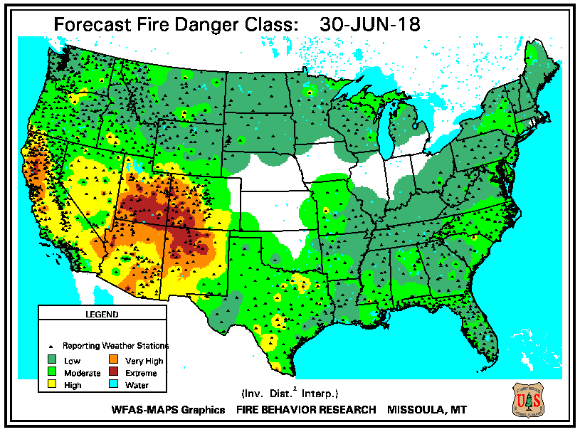
Very high to extreme fire danger levels are predicted for large portions of Utah, Colorado, Arizona, and New Mexico, as well as the lower elevations in Northern California.

Predicted fire danger for Saturday
Predicted fire danger for Saturday.
Fire Weather Outlook
Predicted Fire Weather Outlook for Saturday. NWS.
Red Flag Warnings for Saturday
Red Flag Warnings for Saturday.
Sustained wind speeds predicted
Sustained wind speeds predicted for 3 p.m. Saturday. NWS.

Satellite imagery of Colorado fires

Satellite photo 416 Spring Creek Fires

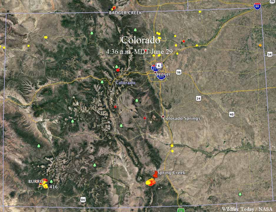
These photos show the location of the wildfires in Colorado, via the heat sensors on satellites. The one above was taken at 1:57 p.m. MDT June 29 when the 416 Fire looked quite active. The Spring Creek Fire was mostly obscured by clouds, but the heat sensor was able to get a peek at it when a hole in the clouds passed over. The data in the map below was from 4:36 a.m. MDT June 29.

map Spring Creek 416 Fires Colorado
Satellite data collected at 4:36 a.m. MDT June 29, showing the heat on the Spring Creek and 416 Fires in Colorado. The red dots are the most current. Click to enlarge.

More information about the 416 and Spring Creek Fires.

Do not use sky lanterns on July 4

sky lantern
Sky lantern release in Chiang Mai, Thailand. Photo by Takeaway.

In the United States July 4 is a holiday commemorating the adoption of the Declaration of Independence on July 4, 1776. For many people it involves fireworks which can be beautiful when conducted by professionals at an organized event, but can be dangerous in the hands of those buying them at tents set up on the side if the road, causing injuries and starting fires.

An especially hazardous device that can be classified as fireworks are sky lanterns. The Jefferson City, Missouri Times Tribune has an editorial, warning about the dangers of fireworks. Below is an excerpt:

…Sky lanterns are another concern. Like other fireworks, they’re illegal to release inside the city limits. However, that hasn’t stopped some people from using the pretty-but-potentially-dangerous items.

Once a sky lantern is lit, the hot air lifts it into the air.

The flaming lantern can travel more than a mile from its starting point.

Wind can affect the sky lantern, blowing the sides, forcing the hot air out and sending it back to the ground, while still burning. A flaming lantern can drop onto a rooftop, field, trees or power lines before the flame is fully extinguished. A destructive fire can result when a flaming lantern reaches the ground during dry conditions.

Obviously, sky lanterns are potential fire hazards beyond other fireworks.

We urge you to avoid them, and to follow the fireworks laws in general.

Too often sky lanterns get caught on trees, roofs, cell phone towers, or land on the ground when the flames are still active and ignite damaging fires. They are banned in most U.S. states and many countries.

Structures lost as Spring Creek Fire in southern Colorado burns 4,000 acres

The Spring Fire in Costilla County, Colorado. Photo courtesy Colorado Division of Homeland Security and Emergency Management Field Manager via San Luis Valley Twitter.

The Spring Creek Fire in Costilla County, Colorado. Photo courtesy Colorado Division of Homeland Security and Emergency Management Field Manager via San Luis Valley Twitter.

(UPDATED at 8:51 a.m. MDT June 29 2018 by Bill Gabbert)

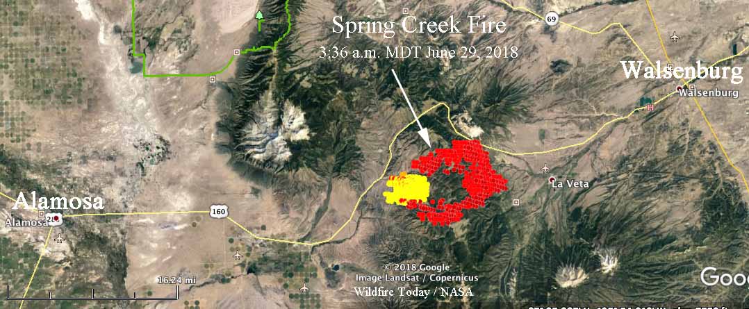
Updated information provided by the Rocky Mountain Coordination Center reported that the Spring Creek Fire has burned 14,424 acres. However infrared data from a fixed wing aircraft that flew the fire at 9:35 p.m MDT on June 28 showed that the fire was significantly larger. The convection column of smoke made it difficult for the equipment to map accurately as it avoided plumes and bounced around. Other information collected by a satellite at 3:36 a.m. also showed that the fire was very active on the east and southeast sides and that it could be much larger as than the last official estimate by the RMCC.

CLICK HERE to see all of the articles on Wildfire Today about the Spring Creek Fire.

There are reports that the fire has crossed and required the closure of Highway 160, the main highway between Walsenburg and Alamosa.

The early information was that the name of the fire was “Spring”, but the official name is “Spring Creek”

Spring Creek Fire
Map showing heat detected by a satellite over the Spring Creek Fire 3:36 a.m. MDT June 29. The data may not be as accurate as desired due to the intensity of the plume. It is possible that the hole in the middle of the fire burned and cooled before the overflight.

Shane Greer’s Type 2 Incident Management Team was scheduled to assume command at 6 a.m. on June 29.

The area is under a Red Flag Warning on Friday, bringing a high potential for rapid spread. Thursday the fire was exhibiting extreme fire behavior with running, torching, crowning and spotting a quarter of a mile ahead. Evacuations  were in progress and multiple residences are threatened.


(Originally published at 11:01 a.m. MDT June 28, 2018 by Jason Pohl)

A wind-driven wildfire in Red Flag conditions blackened an estimated 4,000 acres by Thursday night in southern Colorado, officials said.

The Spring Creek Fire is burning between Walsenburg and Fort Garland in Costilla County, not far from the New Mexico border.  While officials have said structures were damaged and destroyed since the fire started Wednesday, it was not immediately clear how extensive the devastation was.

According to The Denver Post:

“There have been structures lost,” said Linda Smith, spokeswoman for the San Luis Valley Emergency Operations Center. “I do not know whether they were homes. I do know there are a lot of homes in that area.”

Officials declared a disaster for the area Wednesday night.

The cause of the fire is under investigation.

A Red Flag Warning is in place for Friday as much of the region continues to experience record high temperatures.

Saddleworth Moor fire in England contained; hot temperatures to linger

Firefighters work to contain a wildfire the scorched hundreds of acres on Saddleworth moore, near Manchester in the United Kingdom. Photo courtesy Greater Manchester Fire and Rescue Service

Firefighters work to contain a wildfire the scorched hundreds of acres on Saddleworth Moor, near Manchester in the United Kingdom. Photo courtesy Greater Manchester Fire and Rescue Service

Firefighters in the United Kingdom have contained a wildfire burning through the rolling, grassy hills near Manchester, but prolonged hot weather is setting the stage for an unusually active fire season in Britain.

The fires have burned since Sunday on Saddleworth Moor east of Manchester. The location — and rarity— of fires in the area has led to some stunning photos, too.

On Thursday, soldiers from the Royal Regiment of Scotland (4 SCOTS) arrived to provide to support to the approximately 100 Greater Manchester firefighters in Tameside. The fire was said to have burned approximately 2,000 acres, and residents who had been forced from their homes have been allowed to return.

“To have the support of the Armed Forces is extremely pleasing and I know that firefighters will be very appreciative of their help in tackling the multiple fires we are dealing with,” Assistant Chief Fire Officer Tony Hunter said Thursday.

“We have not seen any indication of any rainfall, so this incident is likely to be prolonged for a number of days,” he added. “The fire is contained at the moment, but we only need a change of wind direction to see the fire increase. We are working hard to keep on top of the blaze.”

Temperatures in Manchester have been above 80 degrees Fahrenheit, 10-15 degrees above normal for this time of year based on historical averages.

“The scale of this fire is staggering, and the damage to precious wildlife and unique habitat is unimaginable. There’s lots of speculation about the cause and that is a matter for police and fire service investigation,” said Richard Bailey, from the Peak District Moorland Group, in a statement.

“It is simply not correct for anyone to suggest that moorland management is at the root of this. The reason that this fire burned so fiercely is the extremely dry and hot weather conditions.”

Florida officials: Contractors to blame for prescribed burn that destroyed 36 homes, boats

A wildfire mitigation group contracted by the state of Florida is responsible for a weekend prescribed burn that got out of control and destroyed dozens of homes and several boats, officials confirmed Wednesday.

Florida Commissioner of Agriculture Adam H. Putnam on Wednesday announced that a burn conducted by Wildland Fire Services Inc. on behalf of the Florida Fish and Wildlife Conservation Commission caused the Sunday wildfire in Eastpoint, Florida over the weekend.

Fanned by high winds, the fire burned more than 800 acres and destroyed 36 homes in the small coastal community on the Florida panhandle.

Drone footage of the aftermath is available here. 

“My heart goes out to those affected by this devastating wildfire, and I thank all of our partners in the response effort to stop the spread of the fire,” Putnam said in a statement Wednesday.

The Florida Forest Service led response efforts to contain and control the wildfire with assistance from the Franklin County Sheriff’s Office, Florida Fish and Wildlife Conservation Commission, the Department of Environmental Protection, the Eastpoint Volunteer Fire Department, and other local fire departments.

https://twitter.com/APSouthRegion/status/1012076626799218688

The fire burned through the heavily wooded residential area Sunday near the edge of Tate’s Hell State Forest. No one was killed in the blaze itself, though one man who was trying to help during the evacuation suffered an apparent heart attack and died.

For obvious reasons, the news on Wednesday did not sit will with Franklin County residents. Reporters spoke with several in the area.

From the Tallahassee Democrat newspaper:

“I am so furious right now,” said April Dalton, who lives in the neighborhood hit by the wildfire. “There was a loss of life and damage because someone dropped the ball. Children and families are homeless now because someone did not do their job.”

Dalton said she and her husband escaped the blaze after rescuing their dogs, turning their chickens loose and wetting their house down with a hose. Her husband had to be treated for low oxygen and heat illness later.

John Matthew Polous, a shrimper and oysterman, lost 14 boats, his home and pickup trucks, the Associated Press reported.

“They finally admitted to what done it, now let’s see what they are going to do,” Polous, 51, said while walking through the burned remains of his home. “Why was they even burning this time of year back here? That don’t make sense, but they was and there’s nothing nobody can do about it.”

The Florida Forest Service was among those who joined in sharing an online fundraiser aimed at assisting those affected by the fire. More than $67,000 had been contributed by Thursday morning. The state is also planning on offering immediate financial assistance.