(Originally published at 1:27 p.m. MDT June 1, 2018)
On June 1 the Predictive Services section at the National Interagency Fire Center issued their Wildland Fire Potential Outlook for June through September. The data represents the cumulative forecasts of the ten Geographic Area Predictive Services Units and the National Predictive Services Unit.
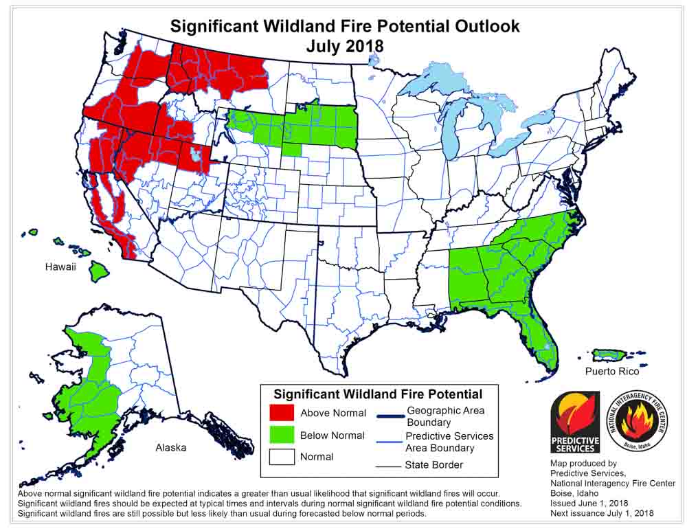
If their analysis is correct, in July the areas with the highest potential will move from the Southwest to Washington, Oregon, Idaho, Western Montana, California, and northern Nevada.
Below are:
- The highlights of the NIFC narrative report for the next several months;
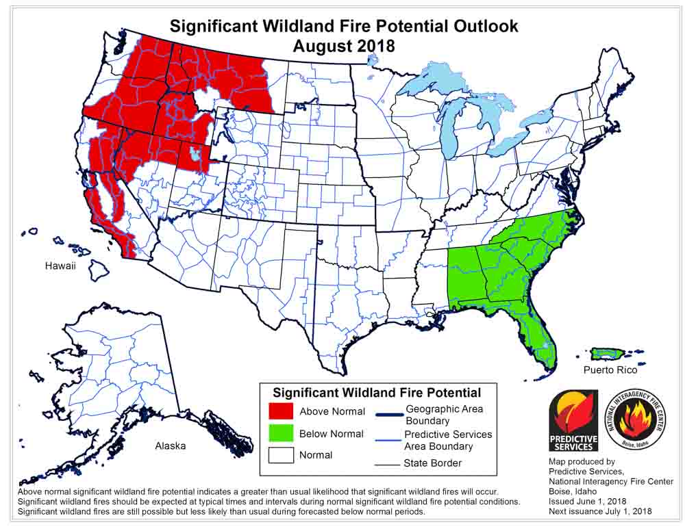
- NIFC’s monthly graphical outlooks;
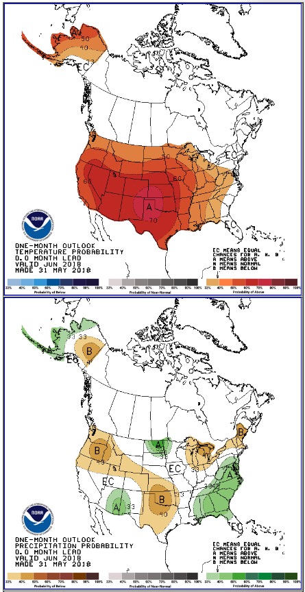
- NOAA’s three-month temperature and precipitation forecasts; and,
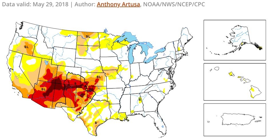
- Drought Monitor.
“Preexisting drought conditions along with continued drier than average conditions across the Southwest allowed for a normal progression of the western fire season across the Four Corners Region and West Texas in May. By month’s end, the focus of activity began to shift westward into Arizona and Southern California. Northern Minnesota and North Dakota experienced above average fire activity as drought conditions took hold. Alaska experienced a slight uptick in fire activity as fuels began to dry. However, the occurrence of periodic precipitation events allowed for a gradual entry into its fire season. Concerning precipitation trends were emerging across California, Oregon, and Washington as most locations received 50 percent of average precipitation or less during May. In the East, many locations across the Southeast, including Florida, received more than 300 percent of average precipitation during the month.
“The combination of deepening drought and the carryover of fine fuels from 2017 is expected to lead to a continuance of Above Normal Significant Large Fire Potential across western portions of the Four Corners Region and Southern California during June. Late June through early July are the peak of fire season across the Southwest and Alaska. During July, activity begins to spread west and north with the drying and curing of the fuels. The Southwestern monsoon begins and reduces fire activity across the Southwest while wetter patterns across Alaska become better established through the month thus drawing its season to a close. These climatologically normal transitions are expected to occur this year as the Western fire season begins to expand and intensify northward.
“Areas of heightened concern will be locations shown on the maps to the left that have both a significant carryover of fine fuels from 2017 and a normal growth of fine fuels this year. In addition, winter snowpack in the higher elevations along the West Coast was well below average, except in Washington State where it was near normal. However, a drier than average spring may offset the average snowpack and melting rates. This should allow for fuels in the mountains to become critically dry by mid-late July. Further inland, the Northern Rockies experienced a very snowy winter, and snowpack is melting at an average rate. However, a wet spring has promoted the growth of a very healthy, continuous crop of fine fuels that should become receptive to fire in the lower and middle elevations by mid to late July.
“August is the peak of the Western fire season. Seasonal transitions focus the fire activity over the northwestern quarter of the country, though California also continues to experience significant activity. With significant carryover of fine fuels from last year and average grass crop growth this year, elevated fire potential is expected through August and early September across many of the lower and middle elevations from the central Great Basin and California northward to the Canadian border. Higher elevations in the mountains may also see elevated fire potential as well should warmer and drier than average conditions develop as expected.
“Typically, a weather event occurs in mid-September that brings moisture to regions experiencing significant fire activity which allows for the western fire season to begin to decrease in activity. Anticipated trends in long range weather data suggests this to be the case this September as ENSO Neutral conditions begin to shift toward El Niño for the fall and winter months.”


