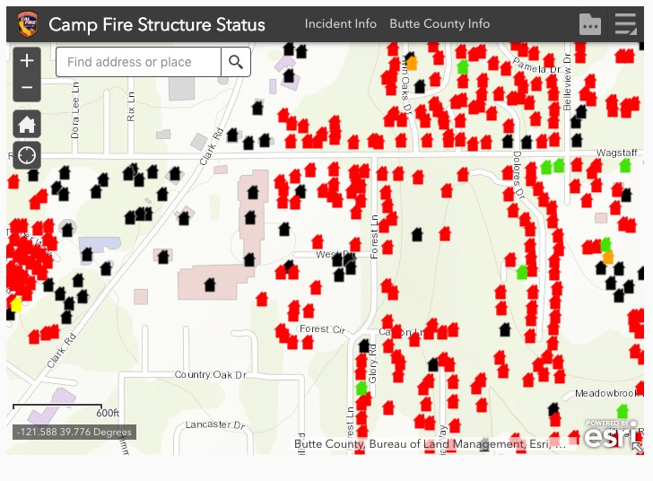
The California Department of Forestry and Fire Protection (CAL FIRE) has released a map that shows the status of structures affected by the Camp Fire. The blaze has burned more than 117,000 acres at Paradise, California east of Chico.
(To see all articles on Wildfire Today about the Camp Fire, including the most recent, click here.)
The data is work in progress and not all areas have been surveyed for damage. The information from the field inspections is subject to change. It appears that the data is not restricted to just structures in Paradise, CA.
To see the map, click above on the “Terms” and then “OK”. After you read the Information, you may want to click on the “X” to remove the box that covers half of the screen.
If the map above fails to work, an alternative is to view it here.
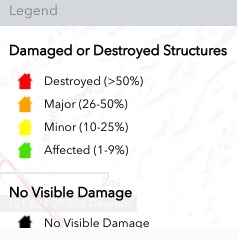
The legend for the map is below:
CAL FIRE reports that 6,453 residences and 260 commercial structures have been destroyed in the Camp Fire.
Congratulations to ESRI and CAL FIRE for developing and releasing this useful tool.
(To see all articles on Wildfire Today about the Camp Fire, including the most recent, click here.)


With deepest APPRECIATION to all of you for the amazing , wonderful work that has been done to reduce the fear of this tragedy by providing heroic efforts to inform and protect our communities. This will go far in the process of healing. GOD BLESS ALL OF YOU!
Where can we find out when we can return to Magalia to inspect our home?
Does anyone know status of Valley View Drive? 300 block? Thanks and God bless everyone.
Does anyone know if 8409 Montna is standing?
Hey Bill. Any new on Mendons nursery -cannot seem to locate on the map thank you
Todd, I searched for 5424 Foster Rd, Paradise, CA on the map and it appears that area has not been covered yet.
How often is this map upgraded. I know that the damage is beyond current images.
Terry, it is updated at least once a day, maybe more often. With approximately 10,000 structures to evaluate, it is going to take a while before they are all completed.
were the homes on bridgeport cir effecfed?
Hello does anyone know about Vista Village apartments off skyway? 60 vista village…
Thank you
I checked the map at 12:47 p.m. November 15 and there was no data for that area yet.
Click HERE to see a zoomable map where a person can search for individual addresses.
Has 6137 W. Wagstaff burned
Has House on 6137 W. Wagstaff RD burned. Two houses on that property, one being a guest house with attached garaged.
Status of 1021 Pleasant Lane.
Our house sits at the north/west end of the lot, 300 feet from Pleasant Lane. There was a large pine tree with our address and an arrow to point in the direction. We had a large workshop on the property.
There is a seasonal stream and 2 other houses in front of our house that also have also have a Pleasant Lane address. One address was 1011 Pleasant Lane.
Status of home at 5427 Edgewood space #7
Hi Bill – This is great information. Very helpful! Is there a way that you can share the underlying data for this? We are trying to find out business partners that might be effected in a more efficient way.
They are now showing the status of more homes in Magalia and Concow. Thank you for providing this.
Where is the Link to this Info.? If you know please send
to dogman.rhythmbyte@comcast.net. Thank You Very Much and God Bless You!
Every thing south of Skyway looks torched. Small area east and north of skyway looks burned. Friends home is safe.
Any news on 14205 Norwich
Is the Kingdom Hall of Jehovah Witnesses in Magalua still sanding?
Does anyone know the status of homes on De Mille Drive?
Please let me know about my home on 6572 Grandview Ave in Magalia! Thank you, Judy Solar
Troy way?
6332 Glendale Dr Magalia Any news or video? We are all safe in Quincy
My friend on Glendale Ct., Her and her Grandparents houses are are gone. It might give you an idea of what to expect.
Any word ocf the area off of Oliver Rd. And Valley View? So many people are in limbo.
Nice article, Bill. I’ll add my congratulations to ESRI and Cal Fire for this kind of mapping. I hope they continue to make major investments in these types of tools. Including “real-time” or near real-time views of active fires shown on maps. With past fires it was incredibly frustrating to try to help friends and families know where the fire was, the direction it is burning, etc. There is SO much technology available now (including commercial/controlled drones with cameras) that could help both firefighters and the public. But someone needs to “put it all together” and make it really work and be reliable. With these scary fires now (unfortunately) part of our “new abnormal”, having better maps and information systems is an important part of our “infrastructure” that needs investment … and it needs involvement from the tech sector.
Try clicking on the little houses near your dot and see if your house or lot is shown. There are photos attached to each little house on the map if you put an address or are in the interactive map. If you are on the other side of the road, it appears they haven’t gotten to that side. I hope this helps. I was checking on friends and saw your comment. Hope you get good news.
Homes on kerr lane burned down
Has 1395 kerr lane burned
Jaramillo Lane and and Edgewood
Is this area burnt down?
Please let us know if you can
6560 Clark Road is not listed on the map yet structures around it are? Does this mean they haven’t had a chance to asses it yet?
Thats how I understand it. If there is no information they have not made an assessment yet. Good luck!
Do you have a link to the map? I see screenshots that don’t link to the tool.
Do you see the large black square titled “Structure Status” with a box to check to agree to the terms? Click on the agree box, then click OK.
Oh, it is a tiny embedded map. If I open it in a new tab, I get the site. I would paste the actual link here, but the comment system won’t let me add links. It rejects it as spam.
A google search for “arcgis camp fire” brings up the site as the first hit.