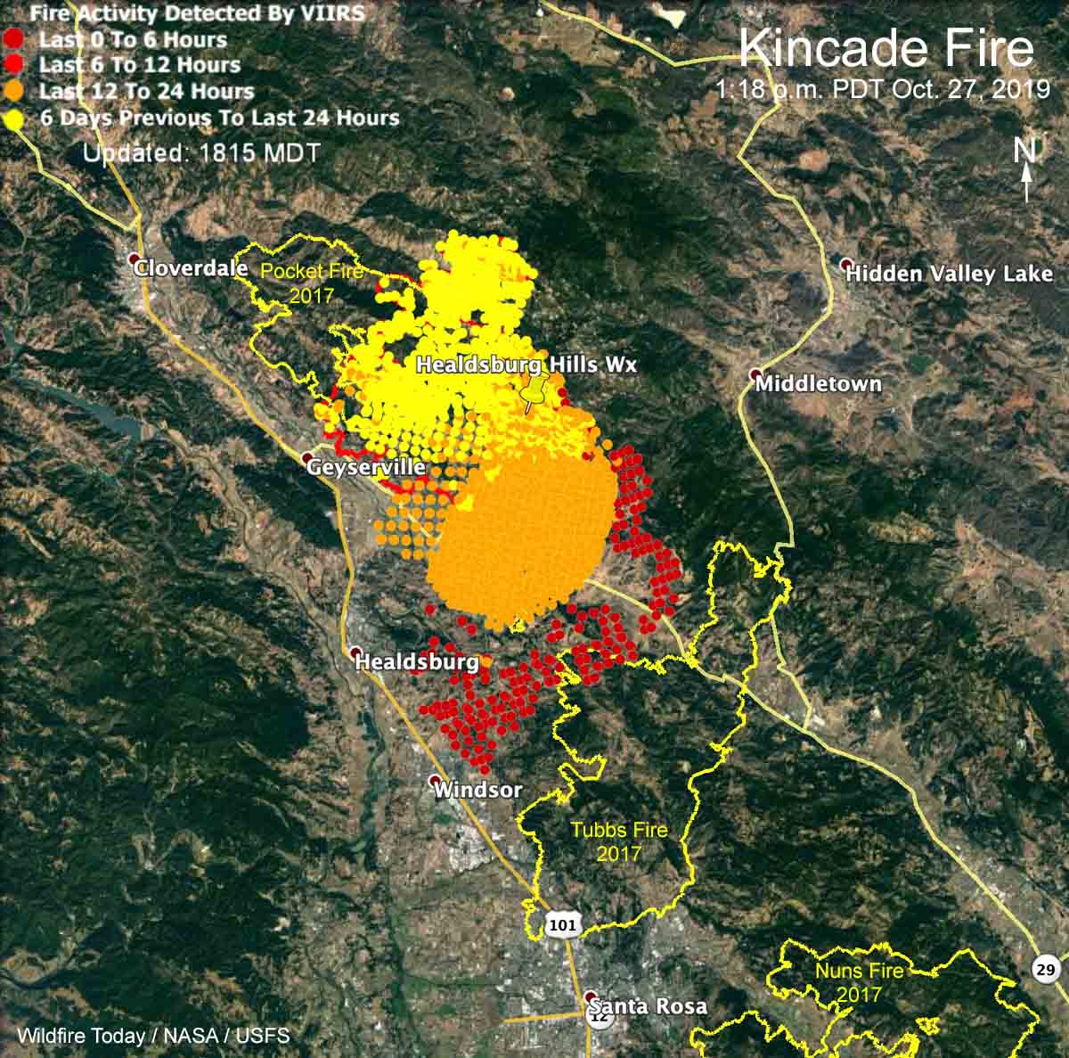
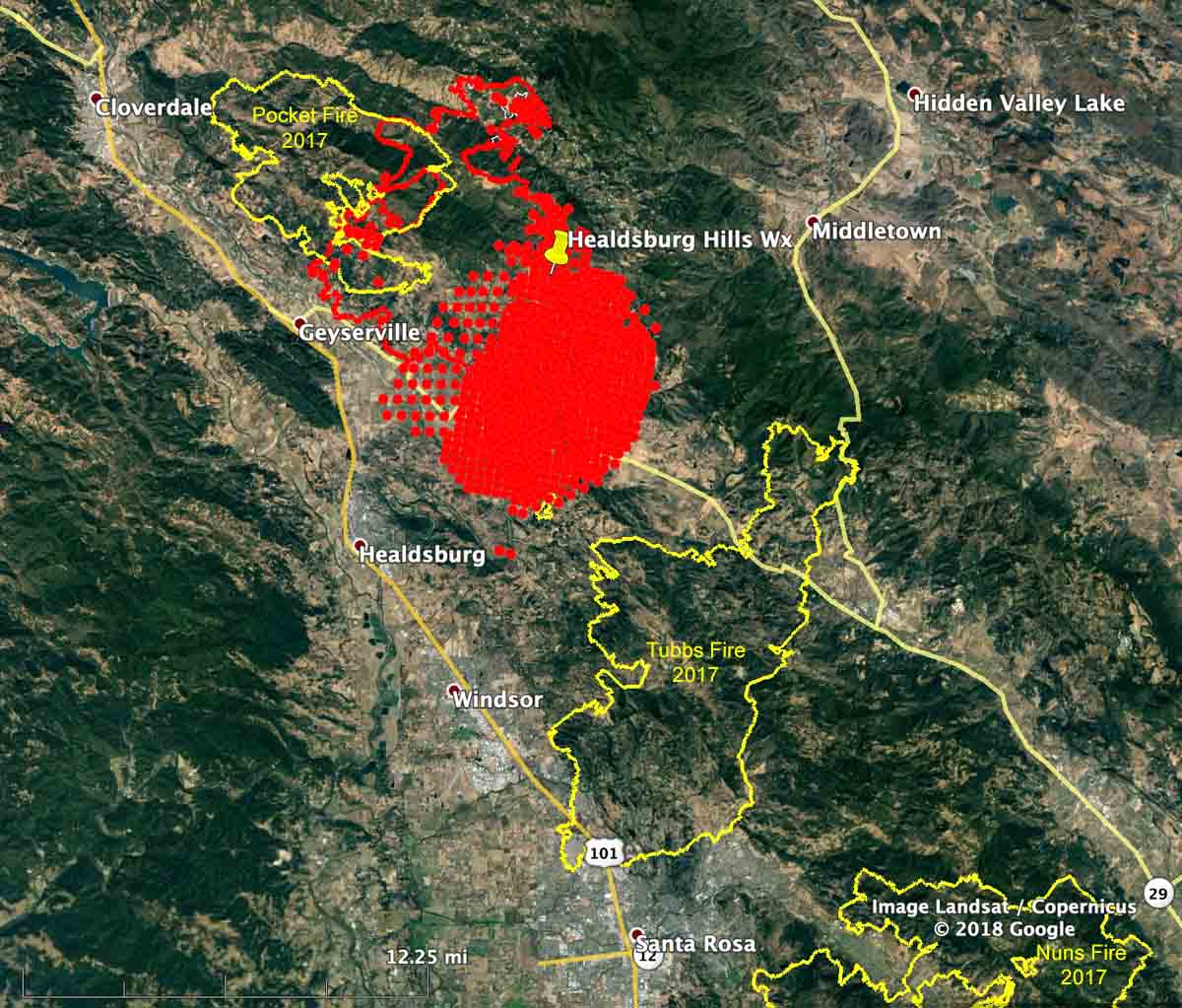
Above: The Kincade Fire as seen from the St. Helena North camera at 9:06 a.m. PDT Oct. 27, 2019. Looking toward Healdsburg.
UPDATED at 5:53 p.m. PDT October 27, 2019

UPDATED at 12:30 p.m. PDT October 27, 2019
At a 10 a.m. press conference fire officials said they hope to stop the 30,000-acre Kincade Fire at the 101 freeway. The area west of the 101 does not have a recent history of fires so the vegetation, or fuel, is heavy and would present even more resistance to control.
After being closed and then open, the 101 is being closed again in the Healdsburg area between Arata Lane and Dry Creek.
Air attack, orbiting overhead and directing aircraft traffic on the Kincade Fire, has ordered large air tankers, hoping that they can be effective in spite of the near hurricane-force winds creating turbulence and possibly blowing retardant off target.

UPDATED at 9:30 a.m. October 27, 2019
Strong winds out of the northeast pushed the Kincade Fire across Highway 128 at about 3 a.m. on Sunday. A gust of 93 mph was recorded at the Healdsburg Hills North weather station at 5:50 a.m. PDT. Ten other weather stations in the area showed gusts at 50 mph or above.

Air tankers are not able to assist firefighters on the ground Sunday morning due to severe wind turbulence making it unsafe to fly and difficult for retardant to accurately hit targets.
Early Sunday morning the fire was about 10 miles north of Santa Rosa, California.
The fixed wing mapping flight at 1:36 a.m. Sunday found that the fire had burned 29,101 acres, but much additional growth has occurred since then.
The fire was moving to the southwest in the general direction of Healdsburg and Windsor. Reporters and photographers on the scene are saying structures, including the Soda Rock Winery, have burned near Highway 128.
We can confirm @SodaRockWinery is burning near Hwy 128 and East Soda Rock Ln. #KincadeFire @KPIXtv pic.twitter.com/MmWQ4KwM2g
— Katie Nielsen (@KatieKPIX) October 27, 2019
For several hours overnight Highway 101 was closed between Santa Rosa and Cloverdale but began to reopen at about 6:50 a.m. Sunday.
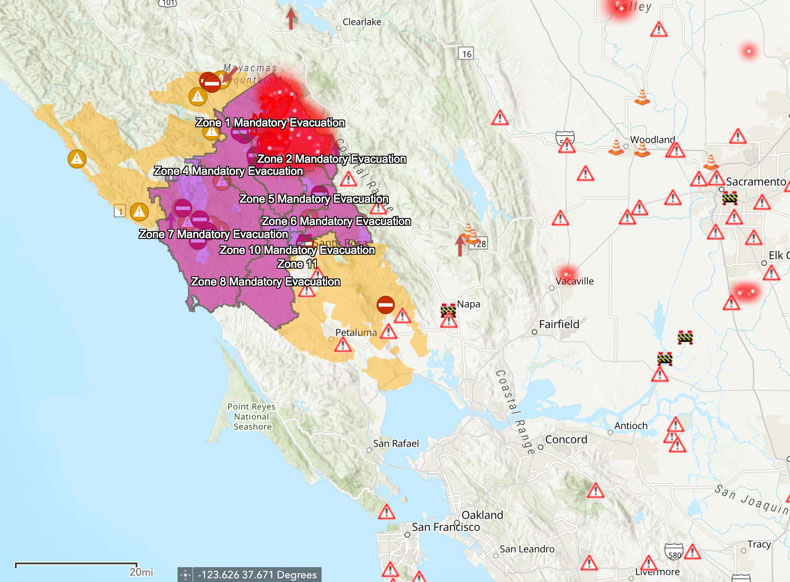
Mandatory evacuation zones stretch all the way west to the Pacific Ocean affecting 180,000 people. Sonoma County maintains current evacuation information, including a zoomable map.

Some gusts near #KincadeFire last few moments are STILL 40-80mph. This is truly a strong and sustained wind event AND we have an out of control racing into more populated areas. More to come… pic.twitter.com/XB2AYbFcRS
— Rob Carlmark (@rcarlmark) October 27, 2019
We will update this article as more information becomes available.


can you show cazadero on the fire map?
Interesting that the Kincade fire does not seem to have been slowed by the burn scar of the Pocket fire of 2017. When we drove up 101 back in April of this year, the area looked to me to have regrown a lot of vegetation. Perhaps we need control burns every year in that area. Or a lot of landscape level forestry mowing. (Full disclosure, I do not own a forestry mower or a drip torch.)
I believe the Incident Command Team took the most prudent evacuation measures considering the complexity of having to manage such a significant incident within a “man made disaster” initiated by PG&E. Typical means of communication; television, internet, and land line phones were unavailable due to the power outage. The best option was to evacuate areas affected in a “worst case scenario “ in an orderly fashion before they would have to commit all their fire fighting resources to a door to door evacuation process instead of fire suppression and structure protection.
Excellent observation & commentary Brad, Thank you for your professional take on an extremely complicated incident command situation involving a well established large wildland fire burning up in the WUI of Sonoma County and then having to add a Diablo wind event of almost unheard of intensity to that same fire incident. So much to learn for us all from this exceptional fire event, especially after a relatively quiet 2019 Fire season in California. It’s certainly not over yet. Fingers crossed that the state gets through this season without another repeat like the 2017 & 2018 Fire seasons. TBC, JB
https://sonomacounty.maps.arcgis.com/apps/webappviewer/index.html?id=2cb4401e1fc0494dbf9d9e22aa794617
/\ A map of the fire that I found helpful.
The Sonoma fire keeps inching towards 101 in Windsor.
101 being a major fire-break.
To the SouthWest, across 101, is a forest & brush area that hasn’t seen fire for about 70 years. i.e., a lot of fuel.
Also a lot of small family wineries and ranches. Like the Foppoli family vineyard.
I think it’s a mistake to evacuate so many people because automobile travellers tend to be a source of fire-starts. Like the car with the trailer & a flat tire that started the Redding fire in 2018.
There are many neighborhoods, such as around the Snoopy ice rink in Santa Rosa, that are defensible.
Besides that a lot of it burned 2 years ago, the residents have gotten the message about removing piles of combustible debris.
https://www.google.com/maps/dir/Geysers+Road/Highway+128/@38.552509,-122.9839335,16075m
/\ Google Map showing the tiny Sonoma County towns that are in the “line of fire”. From Cazadero & Rio Nido to Sebastapol.
I look it up on the map and realize I visited the area once long time ago. It was very wooded and houses are far apart. Imagine taking a shower and can see everything in the deep backyard which has greens as a natural fence.
How long would it take before a spot fire became uncontrollable in wind conditions like this for a building Like The Soda Rock Winery? Looking at the main fire in the hills and the agricultural firebreak of the vineyards I would have expected fireforces all along hwy 128 protecting existing structures from spot fires.
https://www.google.com/maps/place/Soda+Rock+Winery/@38.6604,-122.79925,1909m/data=!3m1!1e3!4m5!3m4!1s0x0:0x89b197722efd35f8!8m2!3d38.6604!4d-122.79925
We have had a couple of days since the breakout of the fire. Was there anything logical and appropriate that could have help prevent this spot burn. I saw a piece on TV this morning where the surrounding area was appeared pretty intact.
thanks
Terry
Terence, when a large fire occurs during strong winds they are spread, not only by convective and radiant heat, but also by millions and millions and millions of burning embers. Most of them land within a few feet or a few hundred feet of the flames, but some are lofted high into the air and land in receptive fuels more than a mile ahead of the fire. They can land in a forest, brush field, grass, gutters full of leaves, in flower beds, mulch, wood decks, rooftops, and can even be blown through vents in the eves of structures. THAT is what burns structures in a large fire pushed by a strong wind. It’s called an “ember shower”.
thanks for the reply
Even with a solid defensible space of non flammable vegetation. (grape vines?) Remember to consider that all of the fire fighting resources on the ground (aerial ones are not available at night) are being stretched over a fire perimeter area the size of SF,(now it has doubled in size as I write) you just to realize that there are no guarantees that a structure will survive when it comes to a wind driven wildfire.
Possibly, you’d have to make the tough decision to stay and defend the property as the fire burned through the area to increase the chances of the buildings surviving fully intact. Easier said than done in a firestorm being driven sustained wind gusts of 45 -65 mph and a peak wind gust of 93 mph. This type of Diablo wind event is just so horribly unfair of mother nature to throw on top of this already very large well established wildfire.
So unspeakably dangerous and downright deadly.
Hats off to all of those brave professional fire fighters and to the awesome Cal Fire incident commanders for making a stand (at night!) to give their every effort to beat beat back the flames, before they take off to the coast, JB.