
(Originally published at 10:09 a.m. MDT June 20, 2020)

The Bighorn Fire north of Tucson, Arizona grew by 5,740 acres Friday to bring the total up to 42,798 acres.
Firefighters have been conducting back burns out ahead of the fire which they hope will serve as barriers to fire spread south of the community of Oracle along Old Mount Lemmon Highway near Peppersauce. They have also been constructing firelines on the west side of the Catalina Highway.
(To see all articles on Wildfire Today about the Bighorn Fire including the most recent, click here.)
For information about evacuations in Pima County contact visit pima.gov/bighorn. In Pinal County check the Sheriff’s Office Facebook page.

The map below shows the growth of the Bighorn Fire over a 24-hour period.

Firefighting resources assigned to the fire include 20 hand crews, 64 engines, 18 water tenders, 6 dozers, and 7 helicopters for a total of 894 personnel.

Many years ago when there was a bad forest fire somewhere, I used to hear my Dad say, “Why did the Good Lord put turpentine in pine needles? The stuff burns like gasoline!”
Yes, why indeed? With a life-long passionate interest in trees, especially conifers, I have come up with a theory as to “why”. I have never seen this documented in books anywhere but it might be there – I just haven’t found it.
The reason the volatile hydrocarbons are in pines needles is that those hydrocarbons don’t quite all go away after the needles die and fall on the ground. Anybody who has ever attempted to start a barbeque grill or a campfire with pine needles or twigs knows this.
So, what that does is allow them to burn when they are damp. Oak, maple, and most hardwood leaves can’t burn when they’re damp but ponderosa pine needles can! If you want to start a campfire after a rain, what’s the first thing you get for kindling? Small oak branches? Nope. Pine twigs – it works.
So, when a forest fire gets started under those kinds of damp conditions, the result is a “cool” ground fire that goes through the forest and kills all the other young trees (like hardwood saplings) that would compete with the pines.
That’s my thought for the day. Somebody on this group will probably tell me I’m full of hops but I still think that’s as good of a theory as any.
Regards,
Fred M. Cain
J.W.,
I wonder how bad the Marshall Gulch area got hit. The forest there, according to “Google Earth” photos, had been regenerating nicely before the Bighorn Fire.
One thing we don’t know is how intensely the fire has burned. The Aspen Fire occurred during a year that was much dryer by far than this year has been. In fact, I think that as recently as a couple of weeks ago they’d had some rain up there. I have no idea how much – probably it was spotty.
My hope and prayer is that maybe the fire swept through much of the forest and did minimal damage. Ponderosa pines are almost unbelievably fire resistant. If, that is, they don’t “crown”. But I do know that at least some crowning went on up there.
I agree with you that this should have absolutely NEVER have happened. It’s beyond stupid, really. Way beyond. “He who does not learn from history is condemned to repeat it”. I’ve forgotten just who said that but it’s very often true.
Please share any information you can find. I have always had a strong love for Mount Lemmon. It’s a very special, unique place.
Regards,
Fred M. Cain,
Topeka, Indiana
(Once a Tucson resident).
Hi Fred,
The original response to the fire was incompetent.100 acre fire has turned into a disaster and now they
are for the most part letting it burn itself out.No one ever imagined that USFS would let what remains
of the Catalinas after the Aspen fire burn uncontrolled.We will pretty much be left with a dead pile
of rocks when it is over.
The absence of meaningful and timely news about the fire is very troubling.I watch it burn through the
canyons each night and have not seen any report on the fire as it burns in Sabino Canyon.All of the other
canyons on the S. side have burned.
I don’t understand why it’s so difficult to get day-by-day updates on this Bighorn Fire. Searching Google News and other online news services, the most recent reports are at least two days old. Even on “Wildfire Today”, this report is over three days old.
Is the fire line that runs on the north side of Summerhaven, Bear Wallow and Mount Bigelow holding? Does anybody know?
Also, how intense is this fire? I have seen pictures of the fire burning through ponderosa pines making a lot of white smoke suggesting that it might be burning at a very low intensity. Does anybody know or have any information on this?
Regards,
Fred M. Cain,
Topeka, Indiana
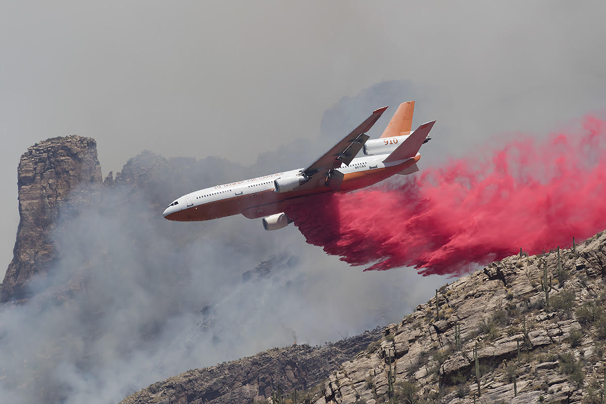
Sweet shot of 910.