Updated October 15, 2020 | 7:33 a.m. MDT

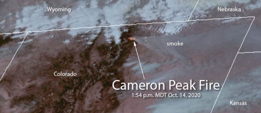
By mid-afternoon on Wednesday the very strong winds gusting to 50 mph that pushed the Cameron Peak Fire about 17 miles to the east toward Fort Collins slowed. A satellite showed very little spread east of Buckhorn Road which is about 6 miles west of Horsetooth Reservoir. Most of the additional acres Wednesday night were on the south side of the 17-mile run, northeast of Rocky Mountain National Park.
At 6:16 a.m. Thursday the Incident Management Team reported the fire had grown to 164,140 acres.
To see all articles on Wildfire Today about the Cameron Peak Fire including the most recent, click here.
Overnight a weather station at the CSU Mountain Campus recorded 5 mph winds out of the west gusting at 10 to 14 mph while the relative humidity remained low, in the low 20s, with a low temperature of 30 degrees.
A mapping flight scheduled for Wednesday night had to be cancelled due to clouds over the fire.
The weather forecast for Fort Collins calls for a shift in the wind, to come out of the east. This could reduce the smoke in the city and the threat to property between Buckhorn Road and Horsetooth Reservoir.
Updated October 14, 2020 | 10:36 p.m. MDT

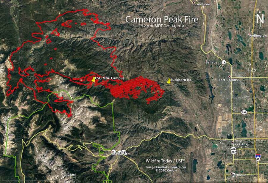
The Incident Management Team updated their map of the Cameron Peak Fire which was pushed by strong winds about 17 miles to the east Tuesday night and Wednesday. By mid-afternoon Wednesday it had reached Buckhorn Road about 6 miles west of Horsetooth Reservoir.
During the extreme growth of the fire structures burned, but until the intensity of the blaze decreases it could be days before the details will be available.
Now at 158,300 acres, it has become the largest fire in the recorded history of Colorado, surpassing the Pine Gulch Fire which blackened 139,007 acres north of Grand Junction a month ago.
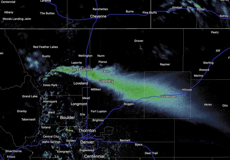
The huge pyrocumulus cloud that formed over the fire was creating rain 100 miles downstream from the smoke plume at 9 p.m. MDT Wednesday.
Updated: October 14, 2020 | 4:18 p.m. MDT
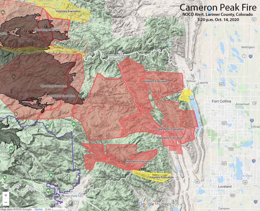
The map above shows the mandatory evacuations have extended east to Horsetooth Reservoir.
A satellite pass at 1:12 p.m. MDT Wednesday, below, shows the spread of the Cameron Peak Fire to the east. At that time is was 8 miles west of Horsetooth Reservoir.
October 14, 2020 | 3:15 p.m. MDT

Very strong winds that began after sunset Tuesday caused the Cameron Peak Fire to become much more active. Mandatory and voluntary evacuations are in effect west of Fort Collins, Colorado (see the map above). This is a rapidly evolving situation.
To see all articles on Wildfire Today about the Cameron Peak Fire, including the most recent, click here.
Wednesday afternoon at about 2 p.m. the Larimer County Sheriff ordered the immediate mandatory evacuation of Redstone Canyon, advising, “Do not delay leaving to gather belongings or make efforts to protect your home or business. For updates, text the word LCEVAC to 888777 from your cell phone. We will communicate information to that key word as needed.”
The Larimer County webpage also has information about the Cameron Peak Fire. Evacuation information can be found at nocoalert.org.
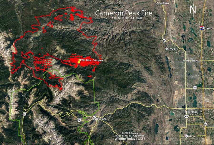
The Incident Management Team reported at 1 p.m. Wednesday that the fire was on top of Signal Mountain, and had spread approximately 10 miles east of the Colorado State University Mountain Campus (CSU). It was spreading to the east and east-southeast, in the general direction of Fort Collins. The smoke plume from the fire is massive and is being detected by radar and satellites.
Tuesday afternoon the weather station at the CSU Mountain Campus recorded 8 to 16 mph winds out of the west gusting at 20 to 38 mph. After sunset the speed increased throughout the night and into Wednesday afternoon blowing out of the west-southwest at 20 to 35 mph gusting at 33 to 50 mph, with a peak gust of 60 at 11:32 a.m. Wednesday. The relative humidity was in the low 20s all night and rose to the high 20s Wednesday afternoon with the temperature in the 30s.
Time lapse sent by a colleague (with permission to share), taken near the mouth of the Big Thompson canyon #cameronpeakfire pic.twitter.com/ECSrjFStSi
— Russ Schumacher (@russ_schumacher) October 14, 2020


We live at 275 Streamside in the Retreat
Have you called the Larimer County hotline and given your contact information to them? They can inform you if there is structure damage after they send in the DAT into the area. The Joint Information Center number is 970-980-2500 and there’s information at https://www.larimer.org/cameron-peak-fire.
This morning the fire is at 167,153 acres with 56% contained. Currently red flag warning conditions until 6PM Saturday (10/17/20). Mandatory and voluntary evacuation areas were added today to the north and east of Estes Park. At 1:30PM (MDT) this was posted on Inciweb “Crews are being pulled from Miller Creek, The Retreat, and Storm Mountain due to extreme fire activity. They are reporting that the fire is moving very fast.” Storm Mountain is about 10 miles NE of Estes Park, I could not find the other two places on the map. FIRMS website shows run going south heading to Glen Haven.
It’s now the largest Colorado wildfire at 158,300 acres at as of 10/14/20. The Pine Gulch fire is now the second largest wildfire in Colorado at 139,007 acres. For now it’s on the west side of Buckhorn road and south of the High Park fire scar.
From the FIRMS website, looks like the fire had a run of just shy of 19 miles to the east.