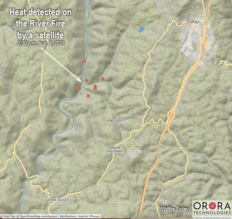
7:29 p.m. PDT August 4, 2021

The map shows heat on the River Fire detected by a satellite at 2:30 p.m. PDT August 4, 2021.
CAL FIRE said that as of 7:25 p.m. Wednesday it had burned 1,400 acres.
6:16 p.m. PDT August 4, 2021
The River Fire in Placer and Nevada Counties 40 miles northeast of Sacramento was estimated at 1,000 acres at 5:45 Wednesday afternoon.
To see all articles on Wildfire Today about the River Fire, including the most recent, click HERE.
This is a dangerous fire and is spreading very rapidly to the north and northeast. Residents that feel uncomfortable should not wait for an evacuation order — officials may not have time to make all of the necessary notifications during this very dynamic event.
From the Placer County Sheriff’s Office (time uncertain, but it was found on the Sheriff’s Facebook page at 6:12 p.m. local time)
**Colfax area EVACUATION Order**
Fire crews are battling a fire near Colfax. There is an EVACUATION ORDER in place for the town of Colfax and the area starting at the Bear River Campground and extending on both sides of Milk Ranch Road to Tokyana Road; West of the railroad tracks to the river; From Mt Howell Rd north to Rollins lake. Gather your essentials and leave the area safely.
Residences that have been evacuated can go to the Auburn Veterans Memorial Hall at 100 East Street in Auburn.
** A secondary evacuation site is yet to be determined**
4:22 p.m. PDT August 4, 2021

Updated at 4:07 p.m. PDT August 4, 2021

A fire that broke out Wednesday afternoon near Colfax, California is already prompting evacuations. The River Fire reported near the Bear River Campground is burning west of Interstate 80 on both sides of the Bear River in both Placer and Nevada Counties.
Colfax is on Interstate 80 about 40 air miles northeast of Sacramento.
At 3:40 p.m. CAL FIRE reported it had burned approximately 100 acres and is north of Applegate.
At least two helicopters, six air tankers, and one very large air tanker have been working the fire, reloading at Grass Valley and Sacramento McClellan.
The Placer County Sheriff’s Office ordered an evacuation for the area starting at the Bear River Campground and extending on both sides of Milk Ranch Road to Tokyana Road, Moorhaven Way, Placer Hills Road, Ben Taylor Road and Hillcrest Boulevard.
The fire is very close to but not within locations covered by a Red Flag Warning Wednesday and Thursday. At 3:50 p.m Wednesday the nearby PG377 weather station on Dog Ranch Road recorded 93 degrees, 17 percent RH, and 7 mph winds out of the southwest gusting to 16 mph. The forecast for Wednesday night is for the wind direction to shift to the southeast and the RH to increase to 35 percent. On Thursday it will be cooler, 85 degrees, with 15 percent RH and 6 to 10 mph winds out of the south and southwest.

I have a truck available for moving small animals and or personal belongings. I used to live in colfax and will help wherever I can. Rocky if you see this contact me immediately.
916-757-2366. Thnx.
Debbie and Kayla
I’ live on 110 Hunter Ln. Colfax Calif. 95713
Do you need trucks and horse trailers to help evacuate?