
5:55 a.m. PDT Sept. 19, 2021
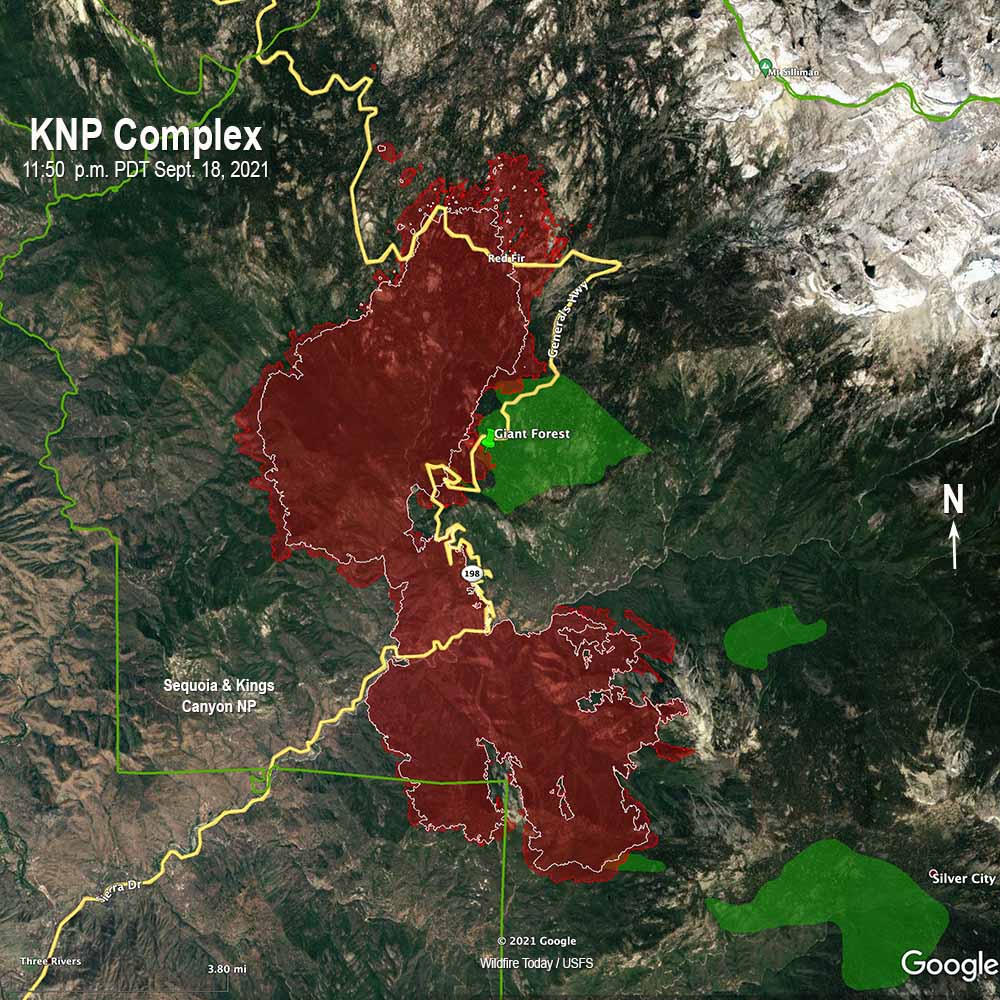
There was less growth of the KNP Complex of fires on Saturday than the day before, but it has spread 1.5 miles north of the Generals Highway northwest of the Lodgepole Visitor Center. Smoke cleared in the afternoon, allowing air tankers and helicopters to resume direct attack on the fire in steep terrain inaccessible to fire crews. This includes areas on the southwest perimeter of the fire nearest the Three Rivers community.

Despite the fire reaching the Four Guardsmen trees in the Giant Forest, the incident management team reported that fuel removal efforts by firefighters, combined with structure wrap applied by crews to the base of the iconic sequoia trees, successfully protected these national treasures.
The fire also crossed the Generals Highway again farther to the north in the area of the General Sherman tree.
The fire was mapped at 21,777 acres by a fixed wing aircraft at 11:50 p.m. Saturday.
A Red Flag Warning is in effect through 8 p.m. Sunday for gusty winds and low humidity. Northwest winds of 25 to 35 mph with gusts up to 45 mph will be possible within the area identified by the NSS, along with relative humidity ranging from the upper single digits to the high teens. However localized forecasts for the fire area on Sunday predict much less wind — near calm becoming east-southeast around 5 mph in the afternoon with 34 percent relative humidity in the higher elevations of the fire.
To see all of the articles on Wildfire Today about the KNP Complex of fires, including the most recent, click HERE.
11:25 a.m. PDT Sept. 18, 2021

The two fires that comprised the KNP Complex in Sequoia National Park in southern California, the Colony and Paradise Fires, merged Friday when the Paradise fire spread north into the Colony Fire. On Friday humidities as low as 10 percent and air that was more free of smoke set up conditions for extreme fire behavior with spotting and sustained crown fire runs. The fire was mapped Friday night at 11,365 acres, an increase of about 6,000.
The fire impacted the southwestern tip of the Giant Forest grove of sequoia trees, the location of the Four Guardsmen trees, when the Colony Fire made a big three-mile run to the northeast, starting spot fires up to one mile ahead. Those four huge trees and others have been receiving attention from firefighters in recent days who cleared around them, removed duff, and applied fire shelter wrap to the bases of the trees.
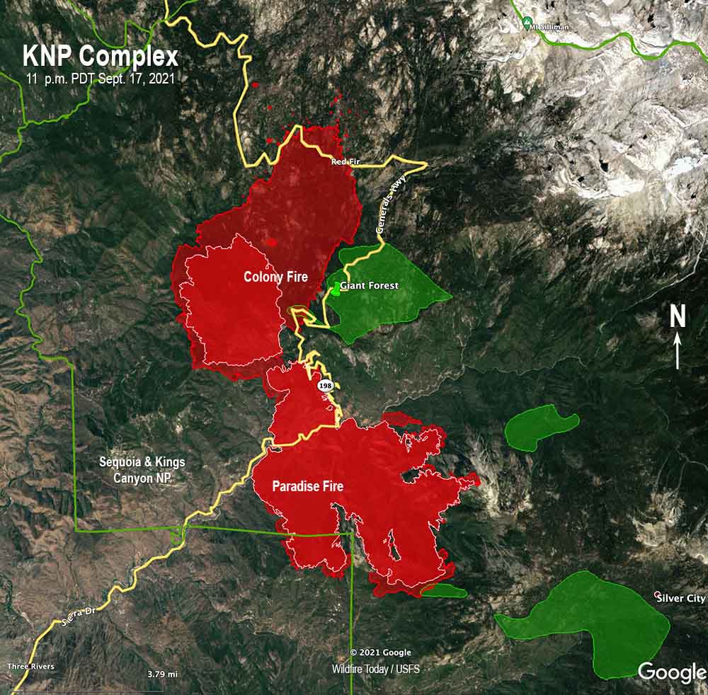
During that three-mile run, farther north the fire crossed the Generals Highway again, this time near Red Fir and Wuksachi Lodge, west of the Lodgepole Visitor Center. Firefighters, to the extent they are available, are working on structure protection in these areas.
CAL FIRE is still constructing the indirect dozer line outside of the park southwest of the fire near Paradise Ridge. When that is complete the dozers will work with masticators to open an old road to Shepards Saddle in the southwest corner of the park, a road popular with mountain bikers. The last step before and if the fire arrives at the old road will be to use fire engines or water tenders to apply fire retardant along the edge of what will become a fire line. Fire retardant is most frequently dropped from helicopters or fixed wing air tankers, but it can also be applied from the ground. This method was used extensively on the Dixie Fire six weeks ago and can be especially useful if smoke makes flying impossible.
A south wind has been causing the fire to spread primarily to the north, so there has been little movement to the south. Operations Section Chief Jon Wallace in a Saturday morning briefing did not mention constructing any direct or indirect fireline on the south side of the fire, but said their personnel are working with cooperators to protect structures at Mineral King.
A Red Flag Warning has been issued for Saturday evening through 8 p.m. Sunday for gusty winds and low humidity. Northwest winds of 25 to 35 mph with gusts up to 45 mph will be possible, along with relative humidity ranging from the upper single digits to the high teens, and with poor overnight humidity recovery. This wind direction with the low humidities could drive an intense fire through the Giant Forest, and possibly the Paradise Peak groves south of the fire.

Bill & Group,
I was just wondering, what were the rainfall totals this past weekend (Sept. 18th & 19th)?
I saw an online news report that it rained in San Francisco so surely the Sierras had SOME rain. However, it may have only rained north of I-80. I don’t know.
Does anybody know?
Buck Rock 2 Camera is pointed right at it. But I can’t tell whether the main activity is the paradise section to the south of the grove. Seems so far off like it wouldn’t be the colony section. The winds from the north right now.
Was there in 2014 favorite part of road trip. Better than the redwoods on the coast.
Another interesting feature is that according to the Situation Report, staffing has not increased, and the number of hand crews and engines listed will be hard pressed to protect the Lodgepole area, Wuksachi Hotel, Giant Forest infrastructure, Ash Mountain headquarters, Three Rivers, Mineral King, and so forth. I suspect one strategy will be point protection, with the fire running through mixed conifer, into red fir, and out into the higher elevation rocks, where feasible. One big problem will be if it gets past Yucca Mountain and turns north into Redwood Canyon and Mountain, the world’s second largest sequoia grove.
With the latest catastrophic fire activity in the West, what’s the LATEST with ST 944???
https://fireaviation.com/2021/09/03/747-supertanker-returning-to-service-in-2022/
Thanks for the heads up. A guy I had been talking to in Moses Lake, where 944 was grounded, informed me of the sale but asked me not to quote him. This is more reliable information. Glad to see, at least, the 747 delivery system going to be utilized, if not in 944. Any idea of location where it will be stationed out of while in the US next year? Again thanks for the update.
After the huge job of rebuilding the retardant system into another aircraft, then the biggest hurdle will be getting a contract for firefighting. Much easier said than done.
Easier said than done
Correct statement only because maybe its a stretch to say that the contract process could stand an overhaul into modern day standards and continually tweaked by folks who do not understand the complexities and costs of owning and maintaining a fleet of sircraft
The wrapped base of the General Sherman tree is a great photo op. popping up all the the interwebs for a salivating media and wishful public, but as most of us in the game know its a rather empty show of force. The ground cover in those groves is already essentially mineral soil from years of tourists tromping around and prep work. With the red-flag conditions predicted, the real threat is running crown fire and the resulting devastating crown scorch.
You know how homes often burn down because embers drift into gutters filled with leaves, eaves, unscreened openings, etc?
Now imagine the base of an ancient tree. Particularly one that has been poked and prodded by tourists for the better part of a hundred years. Dozens and dozens of seams, cracks, soft spots, perhaps areas of rot- mostly inconsequential to a healthy tree . Often filled with duff and organic debris.
Wouldn’t it be real dumb to lose a national treasure because an ember found its way into a speck of nothing at the base?
Quit armchair quarterbacking the people on the ground who know what they’re doing.
Wow, what a negligent, incompetent response to the clearly predictable giant fire that was unmistakably building up strength and threatening these irreplaceable, ancient tree groves! Tin foil tutus as the best and only protection for these majestic ancient trees? The calls for massive help needed should have gone out in due time
Just curious, how much experience in fire management do you have?
Classic really dumb comment: 10% RH and 1 mile spotting; and your response would be to do what? Guess my 40+ years in fire and Ops Chief 1 red card don’t compare to your quals? Nature ALWAYS deals the last hand.