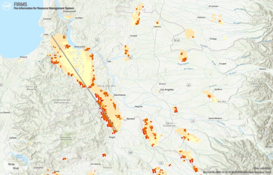
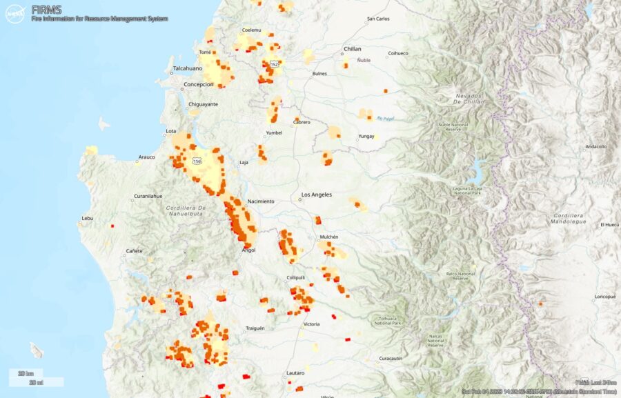
Satellite analyses and Twitter reports indicate a rapid growth of disastrous wildfires in south-central Chile yesterday (February 3) and overnight.
In the past 24 hours, satellite-based estimates based on NASA FIRMS data indicate that the largest fire spread 80 kilometers (50 miles) west and northwest, impacting an area of nearly 100,000 hectares (230,000 acres). The fires appear to have spread from Renaico northwest toward the Pacific Coast city of Lota, while burning past Santa Juana and likely crossing north over the Biobío River.
In this NASA FIRMS map, the oldest yellow heat signatures are 24 hours or earlier, the most recent are red.

A larger map shows 24-hour fire detections for the affected regions of Biobío and La Araucanía. (And a reminder, as the FIRMS mapping tool, these heat signatures may overestimate fire size and activity, in part due to smoke columns and other factors.)

The fires detected by satellites are being confirmed via social media updates. As @HotshotWake reported via Twitter …
This has been some on the worst destruction I’ve seen from wildfires in an urban interface. The first video is of fire activity last night and the second of the aftermath in Purèn, Chile. Whole towns consumed.
@lNFOSCHILE #bomberos #wildfire #chile #fire #southamerica pic.twitter.com/hwhqdraW2o— The Hotshot Wake Up (@HotshotWake) February 4, 2023
Also from February 3, @zoom_earth shared a satellite stream of fires and smoke…
Huge smoke plumes from forest fires in #Chile 🇨🇱🔥 #IncendiosForestales pic.twitter.com/BLTsw6I12a
— Zoom Earth 🌎 (@zoom_earth) February 3, 2023
The Associated Press reported that the death toll as of February 4 has risen to 22 with more than 500 injured. The state of catastrophe has expanded to include the La Araucanía region, which is south of Ñuble and Biobío regions that were already in a catastrophe declaration.

What are the ignition sources? General fuel types?
Here is a pdf report, MPep, for the Maule region of Chile.
” … megafires have become a phenomenon of particular concern. In this study, we develop a model of ignition risk. We use factors such as human activity, geographic, topographic, and land cover variables to develop a bagged decision tree model. The study area corresponds to the Maule region in Chile, a large zone with a Mediterranean climate. …
It is feasible to interpret that the lower number of ignitions observed in the 2019–2020 season is a consequence of the megafire scar. It is crucial to remember that the risk of ignition will increase as forest crops recover. Wildland fire management requires integrating this information into decision-making processes if we consider that the impacts of climate change persist in the area.”