


Update at 9:15 p.m. MT, June 10, 2011:
The incident management team has distributed more information, this time correct they say, about the number of structures that have burned in the Wallow fire. Earlier today they sent out a correction, and now there is still another report from them with the following information.
- “Residences: 29 destroyed and 5 damaged
- Structures: 35 destroyed”
I am guessing that they think the word “structures” means “outbuildings”.
Information from the Type 1 Incident Management Teams running the fire, especially concerning structures, has been slow to be provided, inconsistent, confusing, and filled with errors. They can’t decide if they want to use InciWeb or Google Docs. Or if they do use InciWeb, it may be used in a non-standard fashion, for example showing zero acres burned in the “Size” field on the front page and forcing the viewer to search around or open secondary documents on the site to find that important piece of information.
I have been biting my tongue about this issue, thinking it would be resolved, but if anything it’s getting worse. There have been too many failings from the Information wing of these teams. Teams that are supposed to be the best of the best… the Type 1 Incident Management Teams. I am sure the firefighters are doing their usual great job of dealing with this extraordinary fire. The people in the shiny, clean, yellow shirts running the Information function need to get their sh*t together.
Update at 11:32 a.m. MT, June 10, 2011. The Incident Management Team reported at about 11 a.m. that the most current mapping from an infrared flight last night determined that the fire has burned 408,887 acres. They are still calling it 5% contained, and:
Last night’s operational period included burnout operations, structure protection, patrolling for spot fires, and mop up in the Alpine area. The predicted weather today is expected to allow firefighters to continue burnout operations. Today’s operational period also includes, building fireline using handcrews & dozers around Springerville and Eager, structure protection, patrolling for spot fires and mop up. The DC-10 air tanker was used during yesterday’s operations in the area of Greer.
========================
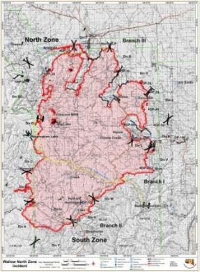
To see a much higher-resolution version of the Wallow fire map above, click here.
A summary of the fire status as of Friday morning, from the incident management team:
This fire (cause under investigation) started 5/29, originated southwest of Alpine, AZ (33 36 7N 109 26 56W). It is being managed under a full suppression (perimeter control) strategy in Fuel Model 8 (Closed timber litter) by an Area Command Team (Loach, IC) with one Type 1 IMT (Reinarz) and one Type 2 IMT (Philbin, IC). Two Type 1 IMT’s moved into management positions this morning at 0600. The fire will be separated into three zones (North, East, and West). Type 2 IMT (Philbin) will transfer out today. As of 6/09 2100, the fire is 5% contained at 386,453 acres (272,490 ac North and 113,963 ac South) with no expected containment date reported.
NORTH: Three-thousand nine-hundred structures reported threatened, one reported damaged (outbuilding), and sixty-three destroyed (29 residence and 34 outbuildings). Difficulty of terrain is high and growth potential is high. Extreme fire behavior with frequent spotting. Rapid rates of spread in all fuel types. Powerlines in the area are threatened. Plan is to focus on securing west perimeter south of Greer and from Escudilla south to Luna, NM, through line construction and burnout. Some resourses will be reassigned to additional zones with incoming IMT’s. Sixteen Type 1 crews, 35 Type 2 crews, 14 helicopters, 192 engines, 15 dozers, 56 water tenders, and other local resources assigned.
SOUTH: One-hundred eighteen structures reported threatened, none reported damaged, and four destroyed (commercial). Difficulty of terrain is high and growth potential is medium. Creeping, smoldering, and active backing fire with short flanking upslope runs. Significant heat generated in canyons on west side of fire. Some spotting continues. Three Type 1 crews, 10 Type 2 crews, 29 engines, 2 dozers, 10 water tenders, and other local resources assigned.
The DC-10 Very Large Air Tanker, Tanker 911, dropped one load of retardant on the Wallow fire on Thursday in support of fire suppression operations near Greer.
A Multi-Agency Coordinating Group (MAC Group) makes decisions about how to prioritize fire suppression resources when multiple fires may be competing for the same resources. Here is an excerpt from the report on the decisions made on Thursday by the Southwest Area MAC Group.
 Below, are more maps, including a map showing the location of the three large fires in the state of Arizona and a map showing heat detected by satellites on the Wallow fire early Friday morning.

The map below, shows the location of the three large active fires in Arizona: Wallow, Horseshoe 2, and Murphy.







