


6:53 p.m. PDT August 8, 2021
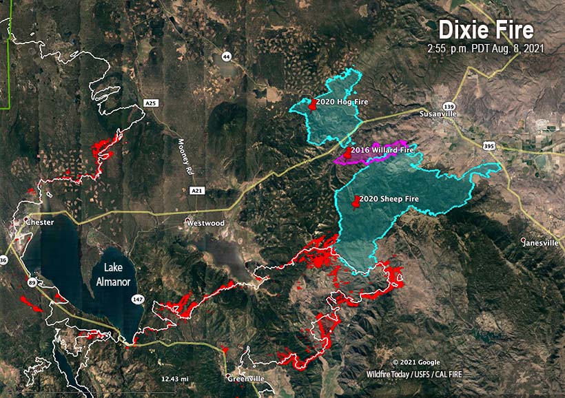
The wind across the Dixie Fire Sunday afternoon was stronger than it has been in several days. A weather station near Susanville recorded sustained 13 to 16 mph winds out of the southwest and west gusting at 19 to 24 mph. Combined with 12 percent relative humidity and very dry fuels the fire cranked up a head of steam and at 2:55 p.m. was mapped after spreading up to a mile east or northeast in the northeast section of the fire at the edge of the 2020 Sheep Fire.
There was little if any movement into the Sheep Fire footprint, but the Dixie Fire was active going around the corners. Presumably after the 2:55 p.m. flight, the limited spread around the edges of the Sheep Fire continued.
To see all articles on Wildfire Today about the Dixie Fire, including the most recent, click HERE.
At that time it was about 12 miles southwest of Susanville.
Sunday afternoon there was also additional fire spread northeast of Canyondam and northeast of Greenville. There was very limited fire movement in the northwest section of the fire seven miles northeast of Chester.
Maps are available showing the status of structures, and evacuations.

The weather forecast indicates conditions favorable for additional fire growth through this week, with warmer temperatures and southwesterly winds.
12:22 p.m. PDT August 8, 2021

The Dixie Fire has grown to become the second largest single fire in the recorded history of California.
Smoke that has remained in Northern California for several days created by numerous wildfires still affected the Dixie Fire Saturday slowing the spread somewhat, but even a slightly slowed Dixie Fire can aggressively chew through thousands of acres. By late afternoon it was putting up large convection columns of smoke easily photographed by satellites 23,000 miles above the earth.
Four firefighters were injured at about 1:30 a.m. Saturday when a tree branch fell on them.
“All four were transported to local hospitals, three of which have been released and one is still in the hospital,” said Chris Waters of CAL FIRE.
There have been no other injuries reported among fire crews or local residents. Two residents of the burned-over town of Greenville remain listed as missing.
The northwest area of the fire north of Chester spread several miles to the east Saturday. By the 9:58 p.m. mapping flight it was near the A25/A21 Mooney Road not far from Robbers Creek, but was still about seven miles west of Highway 44. The fire has burned approximately 463,000 acres.
On the northeast side, a long finger of fire burned up against the 2020 Sheep Fire. From that point it will most likely burn to the north and south of that footprint, and was still 12 miles southwest of Susanville.
The somewhat subdued fire activity over the last two days has allowed firefighters to move in closer to construct more fireline directly on the fire’s edge. They are also installing hose lays, staging pumps and sprinklers, constructing fire line with dozers, and conducting strategic firing operations as conditions allow.
Crews mapping and evaluating the effects on infrastructure have found that 370 structures have been destroyed as well as an additional 175 minor structures. A map is available showing the status of structures.





