


(UPDATE at noon, MDT, May 29, 2014)
The Funny River Fire at Soldotna, Alaska has burned 192,831 acres and the Incident Management Team is calling it 46 percent contained.
Below is a report from the Team:
Cooler, damper weather moderated fire activity on Tuesday which allowed firefighters to switch from defense to offence for the first time since the Funny River Fire started nine days ago. Crews reinforced the containment lines on the west side of the fire in the Kasilof and Sterling Highway areas, and in the Funny River Road area. Progress was made with containment line on the north side of Torpedo Lake on the north side of the Kenai River. Overall fire containment is now 30 percent, with 713 firefighters working to keep the fire away from populated areas.
The evacuation order along the Funny River Road was cancelled yesterday and most residents returned to their homes. All remaining evacuation advisories have been lifted. The Lower Skilak Lake Campground remains closed until further notice.
Five structures were confirmed as lost to the fire. The owners were notified by the Kenai Peninsula Borough. These structures include one outbuilding (the main structure was saved), and four recreation cabins with limited access.
On Tuesday firefighters rescued five abandoned wolf pups on the fire. Check out the story and the photos HERE.
We posted some very interesting satellite photos of the fire in another article.
A tree smolders near Upper Killey River, in an area burned overnight by the #funnyriverfire http://t.co/nRzxlBTKXS pic.twitter.com/0jnFmwlIAh
— lorenholmes (@lorenholmes) May 27, 2014
****
(UPDATE at 6:28 p.m. MDT, May 27, 2014) An update from the Funny River Fire incident Managment team at about 6 p.m. MDT:
Firefighters made excellent progress yesterday extending containment lines on the west side of the fire in the Kasilof and Sterling Highway areas. Crews also completed burnout operations along the northern perimeter (south of Funny River road) late in the day helping to secure areas that had burned over containment lines on Sunday. The fire grew to over 182,000 acres as winds continued to push the fire perimeter northeast towards the Skilak Lake Road and further east into the wildlife refuge area. Overall fire containment is now 30 percent.
The evacuation order along the Funny River road has been cancelled. Residents are allowed to return to their homes. This area remains under an evacuation advisory. The evacuation advisory along the Sterling Highway was also lifted. The Kenai Keys area remains under an evacuation advisory. The Lower Skilak Lake Campground remains closed until further notice.
**** (UPDATE at 10:35 a.m. MDT, May 27, 2014)
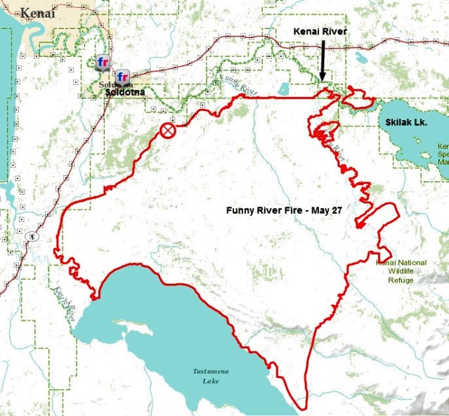
On Monday the Type 2 Incident Management Team for the Funny River Fire at Soldotna, Alaska mentioned that the fire had crossed the Kenai River near Torpedo Lake. The map, above, that we found on the Team’s Facebook page (it is not on their InciWeb page) shows that the fire has become established east of the river. It is no longer just a spot fire. Monday night the Team said the fire had burned 176,069 acres and 670 personnel were assigned. There have been no serious injuries. It is becoming difficult to find current, official information about the fire. Sometimes it is placed on InciWeb, occasionally it can be found on the Alaska Wildland Fire Information site, and then there’s Facebook and ESRI. There is a report from a Twitter user that it is raining in the fire area:
It’s finally raining. Can finally breath. #funnyriverfire pic.twitter.com/gEgoxH8EBO — Shelly Endsley (@mamaendz) May 27, 2014
**** (UPDATE at 8:45 p.m. MDT, May 26, 2014)
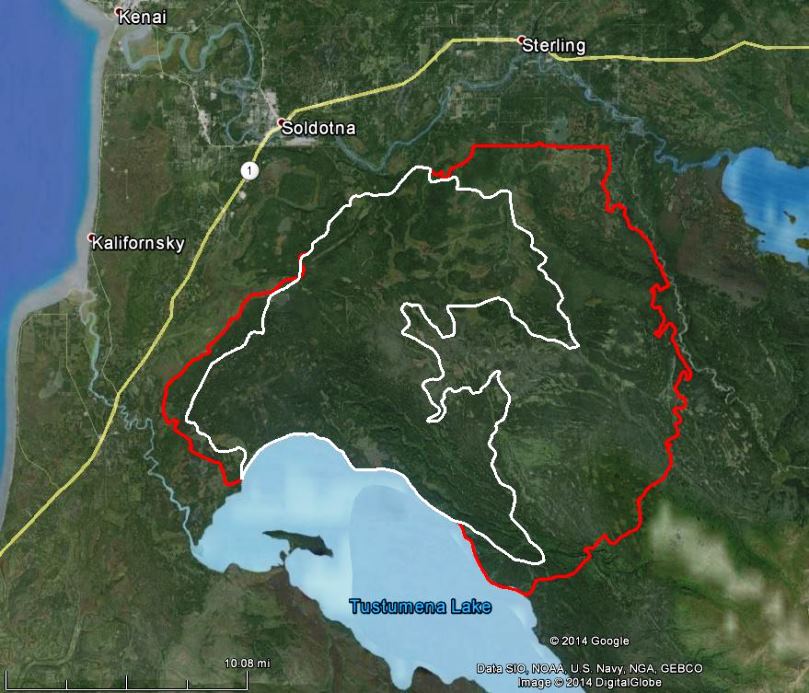
The incident management team running the Funny River Fire at Soldotna, Alaska reported the fire has burned 158,585 acres and it is 30 percent contained. It crossed the Kenai River Sunday afternoon near Torpedo Lake just east of the Kenai Keys. Several spot fires within the Keys did minor damage but were quickly put out. The team is working to confirm if any structures were lost. The wind driven fire is continuing to spread northeast towards the Skilak Lake Road. The Lower Skilak Lake Campground was evacuated and is closed until further notice. The Kenai Keys area is under an evacuation advisory. The weather forecast is calling for rain early Tuesday. Cooler and wet weather will help slow fire activity.
Emotions run high for residents living under #FunnyRiverFire‘s cloud http://t.co/9bBRcb2kRE pic.twitter.com/TNWKGXhSl6 — Anchorage Daily News (@adndotcom) May 25, 2014
**** (UPDATE at 5:07 p.m. MDT, May 25, 2014)

The Funny River Fire at Soldotna, Alaska on the Kenai Peninsula grew on Saturday to cross the 100,000-acre threshold we have informally designated as a megafire, expanding to 123,649 acres according to the Incident Management Team. Strong southwesterly winds associated with a Red Flag Warning produced crown fire runs on the east side of the fire. However, firefighters were able to stop the fire’s northward progress at a fuel break near Browns Lake, south of Sterling and Funny River Road. The video below shows the arrival of the fire at the fuel break. There have been no reports of any structures burning in the fire. Radio station KSRM’s Facebook page has been providing updates.
Wow… Amazing & sad picture of the #wildfire #Alaska pic.twitter.com/Rz15qvIcNo — Will Spear (@AlaskaSpear) May 25, 2014
**** (Originally published at 9:28 p.m. MDT, May 24, 2014)  A fire with an unusual name is about to qualify for megafire status. As far as I know, there is no official definition of a megafire, so I have decided that 100,000 acres is the threshold. Friday at 5 p.m. the Funny River Fire had burned 96,587 acres south of Anchorage on the Kenai Peninsula, but grew significantly Friday night. The fire started at the town of Soldotna and initially burned along Funny River Road. The Incident Management Team is calling it 20 percent contained.

On Friday the Alaska Wildland Fire Information web site, which is an interagency website developed by federal and state agencies in Alaska, posted a map. The fire with an unusual name then had an unusual official map. Apparently on Saturday, someone took a map from the day before, May 23, grabbed a red marker and a pen, and drew in another 18,000 acres or so of red burned area that runs off the edge of the map — and then wrote by hand, “96,587 acres” in the middle of the fire. We have to assume it is legit, since the map is on the official interagency web site, a source for fire information. And the acreage is confirmed on the Alaska site as well as InciWeb. Maybe there were technical problems in producing an updated computer generated map. This hand-drawn version works fine. Well, except for the portion of the fire that ran off the edge of the page. But we applaud the incident management team for distributing needed information. Below is an excerpt from a Saturday morning update from the Alaska Type 2 Interagency Incident Management Team, with Incident Commander Rob Allen.
Yesterday firefighters made further progress constructing fire containment lines along the north and northwest sides of the #funnyriverfire and containment is now at 20 percent. At 5 PM [Friday], the fire was 96,584 acres, but enlarged significantly overnight. 409 personnel are assigned to the fire. Aerial resources supporting the fire suppression effort include five helicopters and four CL215 water scooping air tankers from Canada. The fire continues to actively burn in black spruce and mixed hardwoods due to the continued warm and extremely dry conditions on the Kenai Peninsula. On the east side of the fire westerly winds drove the fire over five miles during an eight hour period; this growth was away from existing communities. Fire growth to the west towards the Sterling Highway during the day was slow, with the fire backing into the southwest winds.
The video below was uploaded to YouTube Saturday night, and apparently shows the fire approaching a fire line near Funny River Road– with very impressive flames. The description says the line held. It’s hard to believe there were no spot fires over the line.
Over on Fire Aviation there are some recently taken photos of air tankers staged in Alaska.
#akfire #funnyriverfire getting dark now and a little smokey close to the ground pic.twitter.com/C6GgZplXvj — LadyKenai (@LadyKenai) May 24, 2014
#funnyriverfire pic.twitter.com/TopaZkxd77 — Megan Schaafsma (@schaazam) May 25, 2014







