Spread of fire near Casper slows

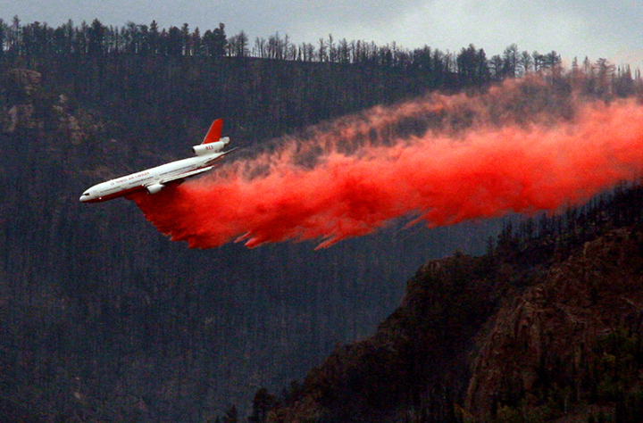
DC-10 drops on Sheep Herder Hill fire on Monday
Tanker 911, a DC-10, drops on the Sheep Herder Hill Complex near Casper on Monday. Photo by Alan Rogers, Casper Star-Tribune. Used with permission. (click to enlarge)

This spectacular photo of Air Tanker 911, a DC-10, dropping on the Sheep Herder Hill Complex near Casper, Wyoming was taken by Alan Rogers of the Casper Star-Tribune yesterday. The photo, along with the video we posted on September 10, tends to disprove the assertions that the Very Large Air Tankers can only be used in “flat or gently-rolling terrain”.

The Casper Star-Tribune has several other photos of the interior of the DC-10 on their web site along with an article about the aircraft. We thank Mr. Rogers for allowing us to use this excellent photograph.

The fire, which became known as the Sheep Herder Hill Complex when a new fire started a couple of miles away Monday night, grew by about 600 acres on Tuesday to a total of 15,887 acres, according to Neal Kephart, a spokesperson for the fire. The Type 2 Incident Management Team led by Incident Commander Todd Pechota took over management of the new fire, named Elkhorn, and aggressively attacked it Monday and Tuesday with engines, aircraft, and smokejumpers, stopping the spread after it burned 8 acres.
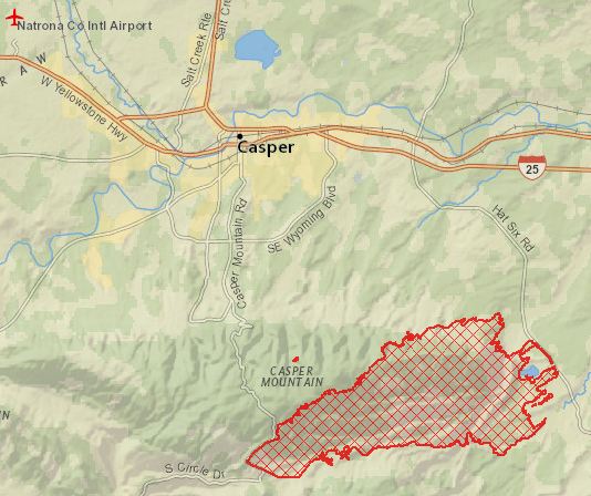
Map of Sheep Herder Hill Complex, September 11, 2012.
Map of Sheep Herder Hill Complex, September 11, 2012. ESRI

Evacuations are still in effect for 150 homes, and another 800 are threatened, according to Mr. Kephart.

Firefighters are getting a break from the weather today, with a forecast for a high temperature of 67 degrees and a 7 to 9 mph wind out of the east and northeast. The relative humidity will bottom out at 21%.

The DC-10 and Tanker 40, a BAe-146, are still parked at the Casper airport 15 miles northeast of the fire along with 4 single engine air tankers, but as of 11:30 a.m. today had not been used yet today.

Other resources on the fire include 7 helicopters (4 large Type 1s, and 3 smaller Type 3s), 17 engines, 4 dozers, and 292 personnel. Two of the helicopters are from the National Guard.


Arrest made in theft of equipment from Alaska hotshot crew

The Alaska base of the Pioneer Hot Shots and the Glacier Gannette crew near Wasilla has been broken into twice in the last four years. After the 2009 ransacking of the base during which most of the crew members’ vehicles were damaged and government equipment was taken from the building, a person was convicted of that break-in and sentenced to 12 years in prison.

In July, 2012 the facility was broken into again. This time there was not as much damage, but state equipment was taken, as well as personal items belonging to the crews and two crew members’ Toyota pickup trucks.

An article in The Frontiersman details an extremely vigorous investigation by Alaska State Troopers which ultimately led to the arrest of one person for the most recent break in. The Troopers found a security video from a nearby hospital that showed the break in, including a large U-Haul truck pulling up to the Department of Forestry Building. They also recovered a stolen GPS receiver that had tracked the thieves after the robbery, and after obtaining a search warrant found similar location tracking information on a stolen iPhone that was in possession of one of the suspects. The iPhone’s data showed the phone had been at the nine locations where a firefighter’s debit card had been used after the robbery.

It is a fascinating story… check it out at The Frontiersman.


Thanks go out to Kelly

Wildfire news, September 11, 2012

American Flag
Photo by Bill Gabbert

Eleven years ago…..

Today, eleven years after the 9/11 attacks on the United States, we will pause for a minute to remember those firefighters and other citizens who lost their lives that day……………….

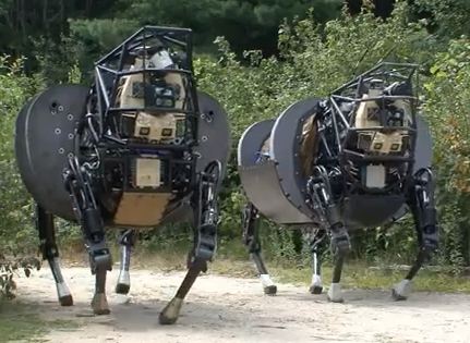
Next Generation legged robots

We first wrote about these “robot dogs” in 2009, and now DARPA has developed the next generation of these machines that are designed to “unburden dismounted [military] squad members by carrying their gear, autonomously following them through rugged terrain, and interpreting verbal and visual commands.”

DARPA's legged robots

I wonder how much water or fire hose these critters can carry?

Amazing air tanker photo

One of the best photos ever taken of an air tanker drop was taken by Kent Porter at the Scotts fire in northern California and can be found at the San Francisco Chronicle web site.

California fire protection fee

The San Francisco Chronicle also has an article that updates the situation in which California owners of habitable structures in areas where the state is responsible for fire prevention must pay a $150 fee. Lawsuits may be filed. Of course.

New map of all large fires this year

The Associated Press has an interesting map that supposedly shows all of the large fires that have occurred this year.

Atomic scientists weigh in on climate change and wildland fires

A publication titled Bulletin of the Atomic Scientists has published an article written by Max Moritz, of the Department of Environmental Science, Policy, and Management in the College of Natural Resources at University of California, Berkeley. (I wonder if all that fits on a business card?) Mr. Moritz writes about how climate change will affect wildland fires and the population. It does not exactly break new ground, with the recommendations being communities should be fire-resistant and we must learn to coexist again with wildfire.

Thanks go out to Kelly

Fire near Casper burns structures and 15,000 acres

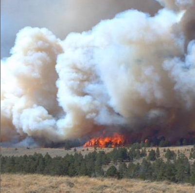
Sheep Herder Hill Fire, Photo by Wyoming State Forestry Division
Sheep Herder Hill Fire, Sept. 10, 2012. Photo by Wyoming State Forestry Division

A lightning-caused wildfire 5 miles south of Casper, Wyoming has burned 15,284 acres south of the city on Casper Mountain. According to the National Situation Report seven structures have been destroyed.

The fire started at 4:30 p.m. on September 9, and grew quickly. A Rocky Mountain Region Type 2 Incident Management Team with Incident Commander Todd Pachota was dispatched to the fire on Monday.

Approximately 150 homes, including 400 residents, have been evacuated.

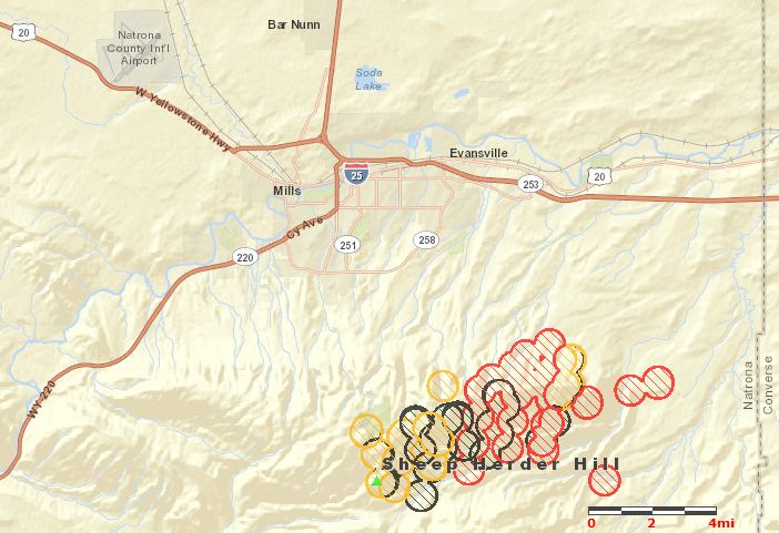
Map of Sheep Herder Hill fire
Map of Sheep Herder Hill fire, 4:27 a.m., September 11, 2012. The city of Casper is located at the icon for I-25.

On Monday Air Tanker 911, a DC-10, left Sacramento with a load of fire retardant, flew to the fire and dropped 11,600 gallons, then landed at the Casper airport, only 15 miles northwest of the fire. It had to sit there for a while as thunderstorms passed over, then it reloaded and dropped on the fire again, for a total of 23,200 gallons. The ship could be an awesome weapon at that fire with very fast turnarounds, dropping 11,600 gallons each time.

The weather on Tuesday will be more moderate than the last two days. The cloud cover will increase to 74% by noon, high temperature will be 75, the humidity will bottom out at 21%, and the winds will be northeast shifting to the northwest at 8 to 14, with gusts to 21 by late afternoon.

A live web cam feed can be found at K2Radio. You have to manually refresh the page to obtain updated images.

The video below is a time-lapse showing the smoke from the fire on Sunday. Unfortunately a tree partially blocks the view.

UPDATE at 12:47 p.m. MT, September 11, 2012:

The Incident Management Team has posted a map of the fire at their InciWeb web site.

Comparing maps for Red Flag Warnings

Yesterday someone commented that red flag warning data from two sources was different. Today we have maps from the sources that were part of the discussion, Google Earth (using the “NWS Fire Weather WWA” data layer) and Weather.gov. The maps were harvested at the same time and show what appear to be exactly the same information about red flag warnings. If the maps are viewed at different times, the data can vary. They are the result of input from dozens of National Weather Service offices, which at various times submit warning data as other warnings expire.

One significant difference is that the Google Earth map more clearly displays fire weather watch areas, while the map from Weather.gov uses what appears to be the same light beige color to display fire weather watches, special weather statements, and hazardous weather outlooks, making that function less useful. But the Weather.gov map seems to have a higher resolution for the boundaries of the warning areas, county by county, if you look closely and squint your eyes.

Which map do you like better?

Red Flag Warnings, Google Earth, September 11, 2012
Red Flag Warnings, Weather.Gov, September 11, 2012

CAL FIRE report about helicopter mechanical failure which resulted in hard landing

Helicopter 101
File photo of Helicopter 101 and crew. CAL FIRE photo.

Two reports are available at the Wildland Fire Lessons Learned Center about a helicopter that made a hard landing in July due to a mechanical failure in a fuel regulator. As Helicopter 101, a CAL FIRE UH-1, was returning from a fire and attempting to land at their helitack base at Howard Forest in Mendocino County, the fuel regulator failed causing the amount of power produced to be less than you would have when sitting and idling. The pilot initiated an auto rotate landing and the helicopter impacted the ground short of the helibase. The skids collapsed, absorbing much of the energy, and the helicopter came to rest on its belly. The pilot and seven crew members safely exited the aircraft without injuries.

More information:

  • Initial report
  • Followup report
  • Information about the Howard Forest Helitack Base