The 405 opens after being closed by the Skirball Fire in Los Angeles

map skirball fire
Map showing the location of the Skirball Fire that started early Wednesday morning in Los Angeles. Click to enlarge.

(UPDATED at 4:40 p.m. PST December 6, 2017)

The 405 freeway has reopened after being closed by the Skirball fire across the freeway from the Getty Center. Los Angeles Fire Department reported Wednesday afternoon that the fire has burned 475 acres and damaged at least eleven homes and destroyed four. Fire officials said 700 homes were evacuated near the Sepulveda Pass.

Skirball Fire map los angeles
The red line on the 3-D map represents the approximate location of the Skirball fire as detected by heat sensors on a satellite at 12:01 p.m. PST December 6, 2017. Later the fire doubled in size. Click to enlarge.

****

(Originally published at 8 a.m. PST December 6, 2017.)

A wildfire that started early Wednesday morning near the Getty Center and Sepulveda Pass has forced the closure of all lanes of the 405 freeway in Los Angeles, one of the busiest highways in the state.

The Skirball fire was reported at 4:50 a.m. and was more than an acre when the first units arrived. Live video from Los Angeles television stations have shown at least two homes with flames on the roofs near Casiano Road. Mandatory evacuations are in effect for the area.

North winds of 8 to 14 mph and a relative humidity in the low 20’s caused the fire to spread rapidly to the south.

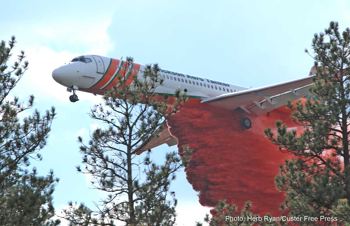
At about 7 a.m. the reported size of the fire was 50 acres, but it may have grown significantly since then. Helicopters, scooping air tankers, and about 220 firefighters were working the fire Wednesday morning.

Thomas Fire burns to the ocean

The fire has burned at least 65,000 acres in Ventura County.

map Thomas Fire Ventura beach ocean 101
The red line on the map shows the approximate location of the Thomas Fire at 2:10 a.m. PST December 6, 2017. The yellow line was the approximate location 25 hours earlier. Unofficial map developed from satellite data. Click to enlarge.

(UPDATED at 10:20 p.m. PST December 6, 2017)

The Thomas Fire north of Ventura, California continued to grow on the northeast side, east of Ojai on Wednesday. The Ventura County Fire Department reported Wednesday evening that the fire has now burned 90,000 acres.

****

(Originally published at 6:36 p.m. PST December 6, 2017)

After burning into Ventura, California on Monday the Thomas Fire continued to grow, pushed by very strong Santa Ana Winds usually out of the northeast. On Tuesday the winds were not quite as strong but the problem for firefighters was the variable direction. Beginning at 11 a.m. winds out of the east and south spread the fire across Highway 33, the route from Ventura to Ojai, through oil fields and over a ridge until it reached and in some places crossed, Highway 101 northwest of Ventura where it reached the beach in some places. Helicopters dropped water on the fire overnight near Foothill Road and at Solimar Beach.

The Thomas Fire is now well north of Highway 150, east and northeast of the city of Ojai.

Firefighters have not had time to accurately tally how many structures have been destroyed — the latest estimate is 150 including the Vista Del Mar Hospital —  but the number may be significantly larger when the smoke clears.

On Tuesday fire officials reported the fire had burned 55,000 acres. Wednesday morning a spokesperson for the Ventura County Fire Department said it had increased to 65,000 acres.

Over 1,000 personnel are fighting the blaze. At least 27,000 residents were ordered to evacuate Tuesday, but that number grew when the fire crossed Highway 33 and threatened the coastal areas.

The wind has made it difficult to use firefighting aircraft, but the forecast for the mountains northeast of Ventura on Wednesday includes 10 to 14 mph northeast winds gusting at 16 to 21. This may make the use of the 30 air tankers that will be in California Wednesday, possible. The forecast also predicts 74 degrees and 9 percent relative humidity, which are weather conditions conducive to significant fire spread.

Three large SoCal wildfires in one photo

Creek Fire Rye Fire Thomas Fire
From near to far, Creek Fire, Rye Fire, and Thomas Fire.

The ABC7 helicopter crew was able to get all three large Southern California fires on one photo at 1:03 p.m. PST today. The nearest one is the 11,000-acre Creek Fire that has closed and crossed the 210 freeway near Sylmar. Next is the Rye Fire, which we have not yet written about. It has burned about 1,000 acres in Santa Clarita.

In the distance is the 45,000-acre Thomas Fire which has burned into Ventura.

Military C-130 aircraft and the 747 activated for Southern California Fires

MAFFS
File photo of MAFFS 1, based at Cheyenne, but is seen landing at Fresno, August 5, 2017. Photo by L.S. Braun.

This article first appeared on Fire Aviation.

(Originally published at 11:53 a.m. PST December 5, 2017)

Two California National Guard C-130’s have been activated by the state’s Governor to assist with the wildfires in Southern California. Two large fires have burned a total of  49,000 acres since Monday afternoon — the Creek Fire at Ventura and the Thomas Fire near Sylmar.

A spokesperson for the 146th Airlift Wing said the aircraft have been activated, they are being prepared, and the Modular Airborne FireFighting Systems (MAFFS) are being installed, but they have not yet received the launch orders.

The MAFFS, which can be installed in a C-130 in a few hours, holds up to 3,000 gallons of retardant.

With the very strong Santa Ana winds currently blowing in Southern California, it remains to be seen if it will possible, safe, or effective to use fixed wing aircraft over the fires. Air tankers have to fly low and slow, and usually over rough terrain. Strong winds can make this unsafe and the retardant can also be blown far off the target.

Very few air tankers on U.S. Forest Service contracts are still active this time of the year. Last Friday there were only four, all in southern California; two CL-415 scoopers and two MD-87’s.

The 747 SuperTanker has also been activated on a CAL FIRE Call When Needed contract and will fly from Marana, Arizona to McClellan near Sacramento today, arriving at about 3 or 4 p.m.

The scoopers are due to end their mandatory availability period on December 6, but it is possible they could be extended due to the current fire situation in southern California. In September the USFS cancelled the last four years of the 5-year contract for the scoopers. The cancellation was to take effect on December 6, 2017.

Beaver Fire, MD-87, T-103, South Dakota,
An MD-87, probably Tanker 103, drops on the Beaver Fire west of Wind Cave National Park September 13, 2017. Photo by Herb Ryan used with permission.

Very strong winds bring Red Flag Warnings to Southern California

wildfire red flag warning weather

(UPDATED at 1:43 p.m. PST December 5, 2017)

The National Weather Service has issued Red Flag Warnings for the coastal and mountain areas of southern California. Strong Santa Ana winds are expected through Thursday, with wind gusts between 60 and 80 mph. The winds will diminish in strength later this afternoon through Wednesday with gusts generally between 35 and 55 mph. However by Wednesday night and Thursday, the winds will increase yet again with gusts between 50 and 70 mph likely. As the Santa Ana winds continue, very dry conditions will persist with minimum relative humidity in the single digits and very poor overnight recoveries.

The Red Flag map was current as of 11 a.m. MST on Tuesday. Red Flag Warnings can change throughout the day as the National Weather Service offices around the country update and revise their forecasts.

Wind gusts speed southern california
Wind gusts during the hour ending at 1:41 p.m. PST December 5, 2017. Click to enlarge.