USFS Chief Randy Moore shared what some called a tone-deaf Labor Day celebratory press release the day after a federal employee union accused the agency Moore runs of continuing ongoing wildland firefighter wage theft.
“We commemorate the struggles Labor Movement activists undertook to provide all workers across our nation with a more fair, just and equitable workplace,” Moore’s post said on the USFS website.
The National Federation of Federal Employees (NFFE) said it’s facing one of those labor struggles under Moore’s leadership. The union saw the agency’s adoption of a new occupational series for wildland firefighters as a chance to end a decades-long tradition of wage theft, but numerous requests by the union went unanswered by the Service.
“After nearly three years of engagement…NFFE has determined it will not endorse the launch of the new series in its current form,” the union’s statement said. “Employees who volunteer to opt-in to the new series will still be performing duties without equal pay for substantially equal work in violation of law, rule, and regulation.”
Numerous aspects of wildland firefighter positions have either been misclassified or not included/graded by service administration, with the Forest Service not accurately calculating time-spent training for or performing major duties on the job, the union said. NFFE requested union employee representation to review and correct errors within the classifications, along with proper representation of EMT duties increasingly performed by wildland firefighters and adopting a career-ladder progression up to Grade 7.
NFFE said USFS failed to correct numerous errors in the new series, including:
Hotshot (IHC) Squadboss: Error in grading factor, Uncorrected.
Engine Assistant: Deceptive acronym used to hide supervisory duties.
Handcrew Assistant: Crew organized improperly to meet stated goals.
Moore, in his Labor Day statement, specified that one of the labor movement’s pillars is fair pay for equitable labor while affirming some USFS employees still fail to meet that standard. He said Service leadership continues to work with Congress to “iron out a long-term solution for a permanent, competitive pay structure,” but NFFE’s recent statement makes it clear the union believes more needs to be done.
Prescribed burns have risen to the top of the most prominent wildland fuel treatments in the world. But while the practice is excellent at reducing fuel loads, it’s been less successful at saving peoples’ homes from the flames.
Research previously published in the Journal of the International Association of Wildland Fire shows that prescribed burns only lessen structure destruction when they’re set close to structures, which adds another layer of careful, costly, and legally challenging coordination of multiple landowners. Depending on the area, relying solely on Rx burns can ultimately be unsustainable and unfeasible as extreme fire weather conditions become more frequent due to human-induced climate change.
Scientists from the University of Tasmania recognized this shortfall and turned to another fire management practice that has received little praise or scientific inquiry: defensible space in the form of gardens.
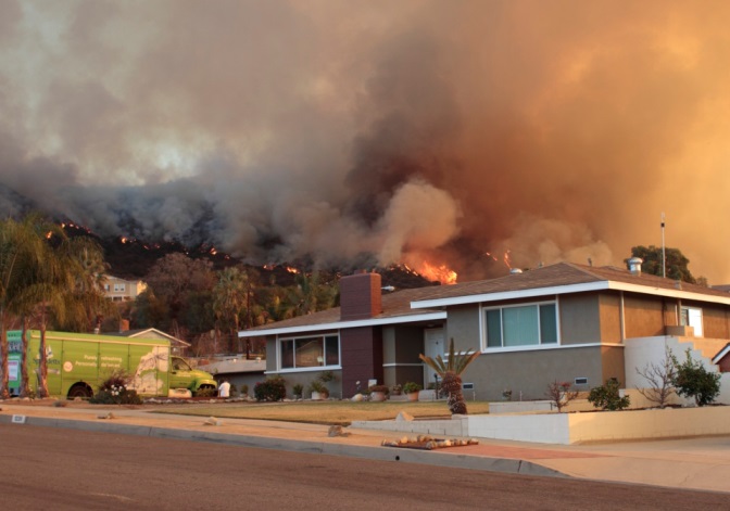
Home threatened by the Colby fire east of Los Angeles, January 17, 2014. Photo by John Stimson.
“Models based on post-fire assessments revealed that garden characteristics, particularly vegetation type and cover near the house, as well as presence of non-vegetative fuels, affect the likelihood of house loss,” the scientific article said. “In one case, they were found to be more important than building characteristics in determining house survival.”
The researchers reviewed defensible space creation guidelines from Africa, Europe, North America, South America, and Oceania to develop key recommended approaches to mitigating multiple fire attack mechanisms, including fuel types, amount, and spatial distribution.
Proper defensible space hinges on its ability to stop radiative and convective energy from crossing a heat threshold and causing a house fire. Energy transfer can occur in numerous ways, including:
Direct flame contact – Potentially the most hazardous wildfire house-loss mechanism since it has the highest heat fluxes with temperature reaching nearly 2,000°F.
Radiant heat – Electromagnetic radiation emitted from thermally hot bodies that cause structure fires when intense.
Firebrand attack – Airborne flaming or smoldering fuel particles lifted by the plume of fire gases and carried horizontally by winds which can set structures on fire or start additional fires in the area.
Direct flame contact represents a high risk, but only in proximity to the house. Radiant heat constitutes a high risk near the house, but quickly declines as the heat source is located away from the house. Conversely, the risk caused by firebrand attacks only slightly decline with distance.
Using the fuel attack mechanisms and an understanding of each region’s common fuel types and loads, the researchers developed key guidelines provided for the whole defensible space as well as a general conceptual model for defensible space including tree zones, open zones, and fuel-free zones.
Ultimately, defensible space is just one of the many practices communities will have to use as fire conditions become more frequent.
“It is important to acknowledge that defensible space is but one component in mitigating the risk of house loss,” the researchers said. “In addition to wildland fuel management, particularly in close proximity of property boundaries, and creation of defensible space, the other major factor is house design124. These last two components are fundamentally interconnected because a well-designed home may be lost to wildfire if fuel management in the defensible space is insufficient, and a poorly designed house may be still vulnerable to destruction from ember attack even if provided appropriate defensible space.”
The left side shows an effective defensible space, with overall low canopy cover, nicely green plants and grass, no vegetation in proximity of the building, and trees and shrubs organised in distinct patches which are not interconnected. With this design a fire approaching from the surrounding landscape would not encroach within the defensible space and, if individual shrubs/trees were to be lit by firebrands, fire would not easily propagate. The right side shows the opposite, where high canopy cover and connectivity facilitate fire spread from the landscape all the way to the house.
The Wapiti Fire has burned 68,123 acres of the Boise National Forest in Idaho as of Monday morning, according to Rocky Mountain Incident Management Team officials. Aerial help is largely restricted as massive smoke plumes bellow into the sky.
The fire’s hottest spots were recorded on the eastern perimeter edge nearing the isolated town of Stanley, according to the NIFC‘s infrared imaging. Town residents are also expected to bear the brunt of the smoke from the Wapiti Fire and the other nearby Nelle, Bulldog, and Flat fires. An air quality alert is in effect until 3 p.m. Monday.
“Along HWY-21 from Lowman to Banner Creek Pass and Stanley, including the entire Sawtooth Valley, will have heaviest smoke impacts,” according to Monday’s smoke forecast. “Tomorrow into early mid-week, warming and drying conditions may lead to more active smoke production.”
Operations Section Chief Travis Lipp said helicopters were briefly able to assist with suppression efforts after the wildfire became significantly more active Sunday afternoon. A hotspot threatened to push eastward toward Highway 21 near Stanley, but two Type 1 helicopters dropped water to cool the fire’s edge.
Officials considered also ordering scooper planes to the fire, but smoke plumes and subsequent poor flying conditions forced officials to hold off on that order. Multiple recons, three Type 1 helicopters, and scoopers are on standby to assist with suppression efforts, but will have to wait until conditions clear up. Smoke forecasts indicate the plumes won’t let up for days.
Structures in Stanley are being prepared for future burnout operations as officials prepare for potential northwest winds pushing smoke and flames even closer to the community.
“Those locally probably noticed some increased fire activity Sunday afternoon in the homestead area,” said Operations Section Chief Travis Lipp in a video Monday. “Crews were able to start putting fire on the ground along highway 21 and around the homestead community. That was continued on through the night into the early hours of this morning until conditions moderated. Today, we’re looking at continuing those burning operations when conditions allow.”
The Red Cross of Idaho and East Oregon opened a shelter in Stanley for Custer and Boise county residents displaced by the fire, along with meals and emotional support. The shelter is at the Stanley Community Center, 510 Eva Falls Ave.
At least two people have died and a total of 48 cities in Brazil’s State of São Paulo are under a “maximum” wildfire alert after arsonists started several fires across the state, according to government officials. More than 7,300 firefighters are working to stop the wildfires.
São Paulo State Government officials told Reuters that the two fatalities were government employees who were trying to fight one of the fires at an industrial plant in the city of Urupes. Officials did not share any further details.
“This means that there are people setting fires illegally, since all states in the country have already been warned and have prohibited the use of managed fires,” Lula’s post said. “The Federal Police will investigate and the government will work with the states to combat the fires.”
São Paulo Governor Tarcísio de Freitas visited the city of Ribeirão Preto Sunday, one of the areas most affected by wildfires in the state. There, he announced the state government has partnered with Brazil’s military to increase airdrops throughout the state.
“In addition to three Military Police helicopters already involved in the operation, the Brazilian Air Force has sent a KC-390 aircraft and two helicopters to help combat the fires. Another 28 heavy vehicles, including Fire Department trucks, are being sent to the city,” the state government’s website said.
Brazil Environment Minister Marina Silva pleaded with arsonists to stop setting fire during a government meeting on Sunday, saying government resources can only fight the flames for so long.
“Even if the federal government and state governments put all their forces into fighting fires, people need to stop setting fires, otherwise they will harm the health and lives of people and animals,” Silva said, according to Lula. “This is an appeal we make.”
Governor goes to Ribeirão Preto where he leads mobilization against fires — Photo: Vinicus Rosa/ Government of the State of São Paulo
The southern area of Brazil isn’t the only region in the nation plagued by fire. The Pantanal in Brazil’s northern region is considered the world’s largest tropical wetland area and one of the most important areas of freshwater in the world. It has also seen an extremely busy wildfire season, with the repeated fires leaving the environment in a state of constant recovery — and nearby communities struggling.
Wildfires across South America increased in both intensity and frequency through the second half of July. The continent’s highest wildfire activity so far this year was in Bolivia and areas of the Brazilian Amazon. Brazilian authorities also estimated this was the worst July in two decades with more than 22,000 active wildfires. Wildfire increases occurred around two weeks earlier than usual during fire season in the region, which historically has peaked in August and September.
The lightning-caused Fish Creek Fire has burned nearly 8,000 acres of Wyoming’s Bridger-Teton National Forest and triggered pre-evacuation notices as of Thursday morning. The wildfire’s total acreage has nearly quadrupled since Monday.
Officials first reported the fire on Aug. 17 at just five acres, but quickly ballooned to 2,250 acres on Monday. USFS officials blame high winds for the spread, and warn the fire may grow even more.
“Fire managers are expecting significant growth again on the Fish Creek Fire [Thursday] afternoon with increased winds and warmer temperatures,” the national forest’s Facebook account posted. “The fires increased growth continues to produce heavy, dense smoke creating limited visibility on US HWY 26/287. Please drive slowly and cautiously in the area with your headlights on.”
Fire danger rating for the national forest and the nearby Grand Teton National Park has been listed as “High” since July 9. A CIMT was ordered and will provide command-and-control infrastructure.
Level 2 “Be Set” evacuation notices were issued by Fremont Emergency Management officials to numerous areas near the fire, including all homes and dwellings on Brooks Lake Road, West Pinnacle Drive, East Pinnacle Drive, Pinnacle Lane, and Breccia Drive. All areas along U.S. Highway 26/State Route 287 between mile posts 30 and 35 are also under pre-evacuation notices.
Fire crews were forced to battle the Fish Creek while managing other wildfires in the forest as of Sunday, including:
Clearwater Fire – Burned 1,966 acres since July 19 and sits at 75% containment.
Leeds Creek Fire – Burned 780 acres and sits at 70% containment.
Merna Butte Fire – Burned 153 acres and sits at 50% containment.
Cottonwood Creek Fire – Burned seven acres and sits at 0% containment. It is burning six miles southwest of the Fish Creek Fire.
U.S. Forest Service-Bridger-Teton National Forest
The forest has a generations-long fire history, with numerous Native American tribes regularly and intentionally burning Northern Rockies landscapes for a variety of reasons including clearing undergrowth, creating wildlife habitat, and reducing fire risk. Forest officials began reintroducing fire to ecosystems throughout the 1960s and ’70s.
Wildfire smoke from Canada has been crossing the North Atlantic since Aug. 10 and reached Western Europe on Aug. 17, resulting in high levels of particulate matter and aerosols like smoke particles in Ireland, the United Kingdom, France, and Scandinavia.
“Evaluation of the CAMS forecasts against independent Aeronet measurements shows good agreement in the timing and magnitude of the [aerosol optical depth] evaluations at several sites, including Cork in Ireland, Camborne in the United Kingdom, and Brest and Arcachon in France,” the service said Tuesday.
CAMS total aerosol optical depth analyses from 10 to 19 August. Source: CAMS
The Northwest Territories, Saskatchewan, and Manitoba recorded their highest wildfire carbon emissions for any August ever in the service’s Global Fire Assimilation System, CAMS reported Tuesday.
British Columbia and Alberta dominated emissions totals for Canada in July, but the number of wildfires and emissions increased sharply in the Northwest Territories through August following heatwaves across the region. Saskatchewan emissions are estimated at over 11 megatonnes for August alone, while Manitoba is currently at over 5 megatonnes.
The new records push Canada’s total estimated August emissions near the level of 2023, when the country experienced its highest emissions since 2023.
“As a result, 2024 is already one of the most extreme years of the last two decades for Canada and is set to be second only to 2023 in terms of emissions,” CAMS researchers said. “The total estimated wildfire carbon emissions in Northwest Territories from 1 January to 19 August exceed 70 megatonnes and are only behind 2023 and 2014 in terms of the annual total fire emissions for the territory.”
CAMS GFASv1.2 daily total fire radiative power (top) since August 1 comparing 2024 (in red) with the 2003-2023 mean (in grey) and total estimated carbon emissions (bottom) for Saskatchewan, Manitoba and Ontario since August 1. Source: CAMS
While evacuation orders remain in place for residents near a wildfire in the Portuguese archipelago of Madeira, worry now turns toward the six-day fire possibly permanently damaging a UNESCO World Heritage Site.
The Curral das Freiras (Valley of the Nuns) wildfire began on Aug. 14 and has since burned 3,000 hectares (7,410 acres) of forest. Regional Government President Miguel Albuquerque claimed arson started the fire, but specifics have not yet been released.
The fire continues to cause issues for the main island’s inhabitants, according to the Regional Civil Protection Service. Officials evacuated 160 residents on Sunday, but many more on the island continue to suffer from the fire’s smoke.
“In Curral das Freiras, the situation causes some concern, due to the fact that the active front is evolving upwards towards the Areeiro peak and branching downwards approaching a residential area in Fajã dos Cardos,” the service said in a Tuesday morning update on its Facebook page. “[Officials] continue to closely monitor the evolution of fires and reiterate their appeal to the population to avoid traveling to the affected areas, for their safety and to ensure a more effective and safer combat operation for the teams on the ground.”
Regional Civil Protection Service President António Nunes recently told the Madeira Journal that the slope-filled area where the wildfire is spreading is “impossible” to fight with land-based resources and said the only solution may be letting the fire burn-out. Pressure mounts as the fire burns some of the Laurisilva World Heritage Site’s 15,000 hectares (37,065 acres), which makes up 20% of the island. The forest holds exceptional environmental importance as it is largest surviving area of primary laurel forest in the world and holds a wealth of ecological niches and intact ecosystem processes.
“No matter how hard it is, no matter how much it may hurt, this is one of the possibilities,” Nunes said. “When it is not accessible, we have to let the fire progress to an area where it is possible to fight it.”
The president’s statement worried UNESCO Chair in Biodiversity and Conservation for Development Helena Freitas, who told Portugal Pulse that the wildfire may do more than burn the “precious treasure” forest.
“There’s nothing that isn’t affected by the loss of biodiversity,” Freitas said. “I don’t even know if we can talk about a recoverable situation, but it is indeed a very singular heritage. We’re talking about a vascular and exuberant flora, with over a thousand species, of which about 20% are completely exclusive to Madeira Island.”
It’s not the first time a fire has threatened Laurisilva, even recently. Arson also started a fire that partially burned the site last October, and caused widespread outrage due to the delay in fighting the fire. Possibly learning from their mistakes in the past, the nation’s Judicial Police have reportedly been investigating the cause of the current fire “since the beginning.”
“Declining to provide details, the source only indicated that the Madeira Criminal Investigation Department ‘is carrying out the investigation procedures that are normal in this type of situation’,” Madeira Island News reported.
Wildfires burned more than 429,000 acres of land in California’s Sonoma County in 2020. The LNU Lightning Complex and the Glass Fire destroyed 1,500 structures and burned numerous grape vineyards.
A new study found during those fires, the county’s government prioritized the county’s wine industry profits over the lives of the people working those fields.
Researchers from the University of California – Irvine and the National Center for Atmospheric Research in Boulder, Colorado, recently published a study in the GeoHealthscientific journal that focused on the safety protections for farmworkers and the effectiveness of air monitoring in Sonoma County. The study found that farmworkers were exposed to high pollution levels from nearby wildfires while being excluded from mandated evacuation zones.
By Dripwoods – Taken of the Hennessey Fire, CC BY-SA 4.0
“Wildfires prompted Sonoma County’s businesses and government to prioritize the wine industry by advocating for initiatives that may put farmworkers’ lives at risk,” the researchers found.
Those initiatives included the adoption of an Agricultural Pass program, which allows farm bosses to apply for permits which allowed farmworkers to keep harvesting crops in mandatory evacuation zones during wildfires.
The study found 96 Agricultural Pass program applications were submitted during the Glass Fire, including 120 worksites and 633 workers. Another 370 permits were submitted during the LNU Lightning Complex yielded 370 permits and included 590 worksites and 1,603 workers. Researchers also said the exact number of workers for each permit is unreliable because of mismatches between permits and the absence of worker counts on some permits.
“Given the program’s lack of oversight, inconsistencies with state-level emergency protocols, and insufficient monitoring of hazardous air quality in the impacted regions, there is a need to further analyze the risks, health impacts, and structural inequalities the program imposes on farmworkers, in particular those who are undocumented,” the study said.
Hennessey Fire August 18, 2020
The researchers suggested a variety of policy changes in regards to their findings, including:
Mandatory Employer Emergency Plans and Emergency Training
Clear Protocols on Identifying Workers and Locations
Real-Time Monitoring of Air Quality
Hazard Pay
Post-Exposure Health Screenings
Post-Incident Accountability and Data Accuracy
Another study conducted in late 2023 found wildfire smoke could be much more toxic than officials previously believed.
Researchers from Stanford University studied soil from the LNU Complex and the 2019 Kincade Fire, finding wildfires can create cancer-causing toxic heavy metals depending on where they burn and the severity of the flames. At the burn scars, the team measured the levels of chromium 6, which is known by most as the toxic chemical from the 2000 film Erin Brockovich, and they found dangerous levels of it in certain areas of the fire.
“Up until now, for wildfires at least, we’ve worried a lot about the fine particulate exposure … what we’ve been blind to is that those ultra-fine particles can differ in composition,” researcher Scott Fendorf previously told WildfireToday. “Even in wildfires that are completely removed from any dwellings, with certain geologies and certain vegetation types which are pretty common, we can see that the particles have these toxic metals in them.”
After more than a year of record-breaking heat, the peak of fire season is approaching across vast swathes of our green planet.
Lots of ecosystems have evolved to withstand regular fires and some are even nourished by it – there are, for example, plants that need flames to help them reproduce. However, rising global temperatures have spawned entirely new fire regimes. Not only does this make life more hazardous, it is also making climate change worse.
“It feels like we are getting used to the Earth being on fire,” say Víctor Fernández García and Cristina Santín, wildfire ecologists at Université de Lausanne and Swansea University respectively. According to their new research, this is a fairly recent phenomenon: extreme wildfires, the kind that killed more than 130 people in Chile earlier in 2024, happen twice as often and are doubly destructive compared with two decades ago.
Fossil fuel emissions have risen by more than a third over the same period. The combustion of coal, oil and gas is the main reason the world is burning more frequently, more intensely and for longer. Climate change has made typically dry wildfire-prone regions even drier and raised the prospect of extreme heatwaves. Animal agriculture and deforestation are also significant causes.
But, as we will see, our rapidly heating climate is breeding fires that are effectively laws unto themselves.
Fire begets fire
“When fires get large and hot enough, they can actually create their own weather,” says Kyle Hilburn, an atmospheric scientist at Colorado State University.
Scientists only discovered that fires could generate thunderstorms in the late 1990s, Hilburn says. His research, using a fleet of satellites launched in 2017, has revealed that the “pyrocumulus” clouds causing these storms are actually common.
Burning vegetation generates heat which warms the air near the ground. This air rises, leaving a void which cold air rushes to fill. If hot air keeps rising it eventually condenses into clouds and some of it freezes. Liquid and frozen particles collide, generating a charge which lightning neutralises.
The parched atmosphere above a wildfire may not produce rain, but the “dry lightning” it does yield will seed new fires in dry grass and brush. The air rising from a wildfire is also buffeted by winds which can make “fire whirls”: flaming vortices resembling tornadoes which scatter hot ash and spread fire further.
Fires beget more fires because of their influence on the local climate. The same is true on a global scale: as forests burn, they release the carbon they stored while growing. More carbon in the air means more climate change; more climate change means more fires, and more carbon in the air.
Russia is reporting a 50% rise in the extent of its wildfires this summer, as enormous blazes hurl smoke into the Arctic Circle. Wreathing the far north of Europe, Asia and North America is the boreal forest, one of Earth’s biggest carbon sinks.
“Over the past few thousand years it has removed around 1 trillion tonnes of carbon from the air, storing it in the trees and soil,” say Natascha Kljun and Julia Kelly, environmental scientists at Lund University.
Kljun and Kelly argue that computer simulations of Earth’s climate could be underestimating the contribution of these wildfires to global heating. According to their research on Swedish boreal forest, CO₂ emissions from burnt areas continue for several years after the flames die.
Pamela L Bonner photo
Hold your breath
Even with a warming atmosphere that turns forests into tinderboxes, a lot of wildfires wouldn’t ignite unless people started them. Some of these are a matter of negligence, like sparks from old power lines.
In South Africa, neglectful landowners that fail to install fire breaks could be sued for allowing fires to burn out of control. Tracy-Lynn Field, a professor of environmental law at the University of the Witwatersrand, believes this could become a powerful tool for limiting the number of fires that break out.
More ruthless regulation may be necessary in wildfire hotspots in western Canada – and not just for environmental reasons.
“In the last two decades, while emissions from most pollution sources [have] declined, Canadians’ exposure to wildfire smoke has increased by approximately 220%,” say health scientists Stephanie Cleland and Ryan W. Allen at Simon Fraser University.
Health experts once studied the sporadic effects of wildfire smoke – how a few days of exposure might exacerbate asthma, for instance. With communities now breathing months of harsh air under smoggy skies, researchers are braced for grimmer outcomes: impaired lung function, higher dementia risk and premature death.
Long-term exposure to wildfire smoke is a mounting public health problem in many places. It’s not just us who are struggling to breathe, though.
“[Plants] respond a bit like us [to wildfires], it turns out,” say Delphine Farmer and Mj Riches, experts in chemistry and botany at Colorado State University.
“Some trees essentially shut their windows and doors and hold their breath.”
Farmer and Riches discovered by accident that ponderosa pines in Colorado sealed leaf-bound pores called stomata in response to wildfire smoke. The trees effectively stopped breathing, halting the photosynthesis that keeps them alive.
The long-term consequences of smoky air in forests are still unclear. But, as with human exposure, the prognosis could be very bad indeed.
In the Christian Bible’s opening book, God calls on humanity to work and keep Earth. It’s this calling that Brother Lawrence at the Our Lady of Guadalupe Monastery refers to when asked why he and his monastic brothers have become pillars of wildfire prevention in Silver City, New Mexico.
“Management is something that has been given to man by God,” Lawrence told the USFS. “In Genesis, Man is put as a steward over nature. And so we need to go out there and do our part in allowing the ecosystem to grow and flourish.”
The monastery is a longstanding champion for the Gila Landscape Collaborative, a community project formed a decade ago focused on protecting the Gila National Forest. The collaboration is partnered with the USFS Silver City Ranger District to get “buy-in” from the community to increase Firewise work on and adjacent to landowners’ properties.
Brother Santiago and his fellow monks continue their efforts reducing wildfire risk as he not only thins trees on the monastery property but is prepared to help when fires break out in their community. (USDA Forest Service photo by Preston Keres)
The monastery was founded in 1990 by Father Cyprian Rodriguez who sought an area of solitude. While remote, the forest was in poor condition when Rodriguez arrived. The area became overgrown through the (in)action of early settlers and historic mining operations, leaving the forest ripe for wildfire. The monastery’s initial efforts to be stewards of the land, however, ended up backfiring.
“There’s been efforts to restore the forest by bringing in species of trees that now have overtaken and become too dense,” Brother Santiago told the USFS. “Perhaps this is the situation for us, but it’s the same for the entire forest, where fire suppression for years has built up the ground fuels. Now, when a fire crew tries to suppress a fire, it’s too much. It’s out of control.”
The Whitewater Baldy Complex was one such out of control fire the monastery faced. The 2012 wildfire burned over 297,000 acres and destroyed 12 structures. The complex originally began as two fires, the Whitewater Fire managed under a suppression strategy and the Baldy Fire managed and monitored under a “modified suppression” model.
The near-constant smoke which impacted the monastery during the complex and the long-lasting burn scars left in its wake motivated the brotherhood to begin focusing on fuel reduction efforts and spreading the good word of fire safety throughout their community.
“The Benedictines have unique perspectives, values, and insights they bring to the table,” Silver City Ranger District Fuels Planner Daniel London said. “It’s also valuable to have someone outside the government stressing the importance of this work. They live here. They have a special connection to it. They’re some of the best people to share this important message.”