A group of four law firms in Oregon and California has sued the Eugene Water and Electric Board (EWEB), Lane Electric, and Bonneville Power Administration (BPA) for their roles in the Holiday Farm Fire east of Eugene, Oregon — part of the Labor Day fire siege of 2020.
In the approximately 200-page lawsuit, attorneys claim the three utility companies neglected to prepare electrical operations and equipment before the fire burned across 173,400 acres and destroyed more than 700 structures. The Holiday Farm Fire burned on the Willamette National Forest, BLM lands, and private property within Oregon Department of Forestry protection units. The lawsuit was filed on behalf of 238 victims who lost homes and property in the fire; the suit asks for $232 million.
As of September 10, 2020, the Holiday Farm Fire — named for a local tourist attraction called the Holiday Farm that included a wedding venue, RV resort, and year-round holiday Christmas gift shop — had burned over 144,600 acres about 14 miles up the McKenzie River from Eugene. Fire behavior and weather conditions were treacherous and kept firefighters from entering many areas, but they did protect some homes by burning out around them.
Jennifer Singh of KEZI in Eugene reported that the case was originally filed with Lane County Circuit Court against Lane Electric and EWEB — for neglecting to safeguard space around their powerlines from unstable trees and other hazards, but new records have revealed evidence that BPA also played a role in the disaster.
The lawsuit should come as no surprise to anyone — except maybe BPA — because local residents and fire officials were discussing the likelihood that the Holiday Farm Fire was ignited by powerlines while it was still in the initial attack phase.
Holiday Farm Fire — Oregon Daily Emerald photo
“It wasn’t until the end of last year that we discovered new evidence that pointed to Bonneville Power Administration sparking a second fire,” said Alex Robertson, one of the four attorneys for the plaintiffs. He said that second fire merged with the Holiday Farm Fire. BPA provided power to EWEB and Lane Electric, and failed to power down its lines in a public safety shutoff. On Labor Day a danger tree fell onto a BPA line on Highway 126 and ignited another fire about 4 miles away.
This is the evidence that caused the law firms to bring BPA on as a co-defendant for the suit filed as a federal case — BPA is a federal agency, so unlike previous cases in county circuit court, this suit will be heard in federal court. The earlier case filed against Lane Electric and EWEB was dismissed to combine with the suit against the BPA.
Robertson said that on the same day the new lawsuit was filed, January 16, another suit was filed by 60 insurance companies seeking reimbursement of claims already paid to homeowners.
The Forest Service and Inciweb have wiped most of the records of the fire from their websites, but a BAER summary [PDF] of the Holiday Farm Fire is still available online.
PacifiCorp will pay another $85 million to nine more victims of the 2020 Labor Day fires, after a jury in Multnomah County on Tuesday recorded the latest verdict in a series of lawsuits that means billions of dollars in liability costs for the Portland-based utility company, according to an AP report.
“PacifiCorp has settled and will continue to settle all reasonable claims for actual damages under Oregon law,” the utility said. The western Oregon fires were among the worst in the state’s history, killing nine people, burning 1.2 million acres, and destroying upward of 5,000 homes and other structures. Though the extreme fires were not unprecedented, the Labor Day fires burned more of the Oregon Cascades than had burned in the previous 36 years combined.
From one of the exhibits at trial establishing PacifiCorp’s liability
A jury in June found PacifiCorp liable for negligence in its failure to de-energize powerlines for its 600,000 customers — after the utility was warned by fire officials and emergency managers that its powerlines had started multiple fires and that there was an emergency need to cut power in at-risk areas because of the extreme fire danger.
Plaintiffs were awarded $71 million in that case.
PacifiCorp agreed last month to pay $299 million to settle a lawsuit by 463 plaintiffs who lost homes and other property in southern Oregon wildfires in September 2020. That jury awarded around $90 million to 17 homeowners. The award on Tuesday was the first of cases brought by plaintiffs in the broader class-action suit. More trials are set for February and April.
In 2018 Rick Stratton, a USFS fire planning program manager for the R6 Regional Office in Portland and Pyrologix provided a Quantitative Wildland Fire Risk Assessment for communities most at risk in the Pacific Northwest — and he listed the top 25.
Six years later he compared that assessment with what had actually happened, and 18 of the 25 communities had recorded significant/catastrophic wildland fires. His assessment illustrates a rapidly evolving wildland fire environment, in which entire communities are at risk. Below are some of Stratton’s slides.
How do interface disasters occur? Jack Cohen‘s work on wildland/urban interface fires demonstrated that in the beginning, the set-up for a disaster fire includes extreme fire conditions — much of which has been widespread across the West over the last decade or more. Abundant dry fuels, fire-friendly weather such as drought, extreme heat, low humidities, and high winds all contribute to a landscape ready for a fire disaster.
To that setting is added both wildland fire (with rapid spread) and urban fire — which includes multiple simultaneous ignitions and residential areas in which fire spreads from house to house to house, complicated by non-vegetation burning of cars, fences, decks, garages, stacked firewood, and often-hazardous materials typically found on interface industrial properties, workshops and garden sheds, or even gas stations. Frightened residents trying to evacuate on limited access routes, often with uncoordinated communications and plans, simply multiply the crisis.
Pacific Northwest risk map: Clearly illustrated here is the band of interface-populated communities that runs down from the northeast corner of Washington to the southwest corner of Oregon — adjacent to and in forested areas.
Unlike the larger metro areas (Seattle, Portland), these communities are surrounded by rural and forested land, and consist mainly of smaller communities with limited suppression resources, and sometimes challenging water supply or prevention resources.
… and … 6 years later:
Interface fires in Northwest communities at risk fir catastrophic interface fire
Only a few of those ranked community exposure locations were NOT burned by a large interface fire. Ellensburg, Washington, suffered multiple fires, as did Spokane, Grants Pass, and Chelan.
Joe Stutler
A Western Region Co-Chair for the Wildland Fire Cohesive Strategy, Joe Stutler worked 35 years with the U.S. Forest Service. Since retiring, he’s worked for Northtree Fire International and as senior forester with Deschutes County for 8 years. He has worked as a hotshot, smokejumper, district and forest FMO, district ranger, law enforcement officer, and regional fire operations specialist for both R5 and R6. He put in 33 years as Type I and II Incident Commander and 6 years on National Area Command Teams. He has managed all-hazard and law enforcement assignments across the country and currently fills Command and General positions on Type 1 IMTs and Area Command teams.
Here are a few of Joe Stutler’s thoughts on these risk assessments: I am wide-eyed at the accuracy of Rick Stratton’s predictions and the big fires that followed in 2018-2022. Most of these high-ranking landscapes were in Fire Regimes 1 & 2, and those that have been burned by large intense wildfire have now reset to Condition Class 1. But what about those that remain in Condition Class 3, like here in central Oregon and other places in the U.S.?
The wildland fire environment is rapidly changing, and this slide deck shows that to be true. The question is, what can we in the business of helping people understand it actually do about it? The answer lies in collectively and strategically communicating these issues.
From my world, I immediately think about how the Cohesive Strategy has been affirmed by the Wildland Fire Leadership Council (WFLC) AND the President’s Wildfire Mitigation and Management Commission as THE strategic framework that can be applied at and by every level (federal, tribal, state, local, and NGOs) to address wildland fire challenges to make substantial, meaningful progress toward landscape resiliency, community resiliency, and fire adaptation — and a safer, more effective, risk-based wildfire response.
The part that stands out to me (apart from the obvious needs to increase the pace and scale of landscape resiliency treatments and address the different response approaches and needs of the “urban firestorm” probability) is the need for doubling down toward the CS goal of fire-adapted communities. The goal is described as “communities that are as prepared as possible to receive, respond to, and recover from wildland fire.”
This elevates the responsibility for preparedness to more than just our response as land management agencies and organizations, but to us as residents, responders, planners, emergency managers, governments, businesses, news outlets, and other organizations in communities. We each have a responsibility to think about what RECEIVING FIRE, RESPONDING TO FIRE, and RECOVERING FROM FIRE means to each of these community affiliates — and start heading down the path of preparation. These are ripe for defining within communities and providing suggestions for action. The definitions and suggestions will be different in every community, and we can organize and assist with these conversations, suggestions, and actionable solutions.
Many best practices have been applied and are underway across the West by all these entities, but the devastating destruction of entire communities over the last decade tells us that there is still much to do at the community level to prepare for wildland fire. Even today, many communities across the West — and for that matter east of the Mississippi — still do not realize that not only is the wildfire risk high, but there is also high likelihood of loss given the rapidly changing wildland fire environment. A changing climate (hotter, drier, windier conditions) alone is making “urban firestorms” a more prevalent reality, even in the East and South.
It’s clear that we need efforts toward all three goals of the Cohesive Strategy to make a difference and change the outcomes of wildland fire. Our vision is a good place to start — “To safely and effectively extinguish fire, when needed; use fire where allowable; manage our natural resources; and collectively, learn to live with wildland fire.” If we as individuals are truly learning to live with wildland fire, we must consider what that looks like in the face of the research and outcomes that Rick Stratton shares and then apply the Cohesive Strategy for better fire outcomes.
Ignoring our responsibility to learn to live with wildland fire is a choice. And we now know what the outcomes of that are.
Longtime federal agency official Angela Gladwell has “overseen” the $4 billion compensation fund that was supposed to pay victims of a disastrous 2022 New Mexico wildfire accidentally started by the Forest Service. Her resignation follows resounding criticism of FEMA’s handling of payments that were funded and due residents for damages caused by the Hermit’s Peak / Calf Canyon Fire, which destroyed over 400 homes and racked up literally billions of dollars in suppression costs and damages.
Angela Gladwell’s actually being “reassigned,” because the Federal Emergency Management Agency is “restructuring” its disaster response in New Mexico — in part because of loud and long criticism of its handling of disaster aid and damage payments — which Source New Mexico and ProPublicahave followed for the past year.
A year after the fire, the FEMA claims office had paid less than 1 percent of its total funding allocated.
In a news release announcing Gladwell’s departure, Deborah Martinez with the claims office said she “successfully built a compensation program from the ground, assembling a team of locally hired staff with knowledge of New Mexico and the communities affected by the wildfires.” Martinez said Gladwell will now “transition to a new role” as FEMA consolidates recovery programs in the state. She would not, however, answer questions about what that “consolidation” might entail.
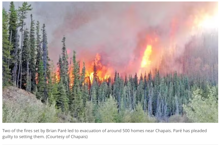
A Quebec man who posted conspiracy theories online — including that forest fires were being deliberately set by the government — has pleaded guilty to igniting fires that forced hundreds from their homes during last summer’s brutal Canadian fire season.
On Monday Brian Paré, 38, pleaded guilty in Quebec to 13 counts of arson and one count of arson with disregard for human life. The CBC News out of Montreal reported that prosecutor Marie-Philippe Charron said two of the 14 fires he lit caused the evacuation of 500 homes in Chapais, a community about 425 kilometres northwest of Quebec City.
“On May 31 at 8:30 p.m., the town of Chapais issued a mandatory evacuation order due to the raging fires,” Charron said, “in particular the fire at Lake Cavan as well as the airport fire, two fires that are included in the charges and were caused by the accused.”
Residents of Chapais could not return home for three days.
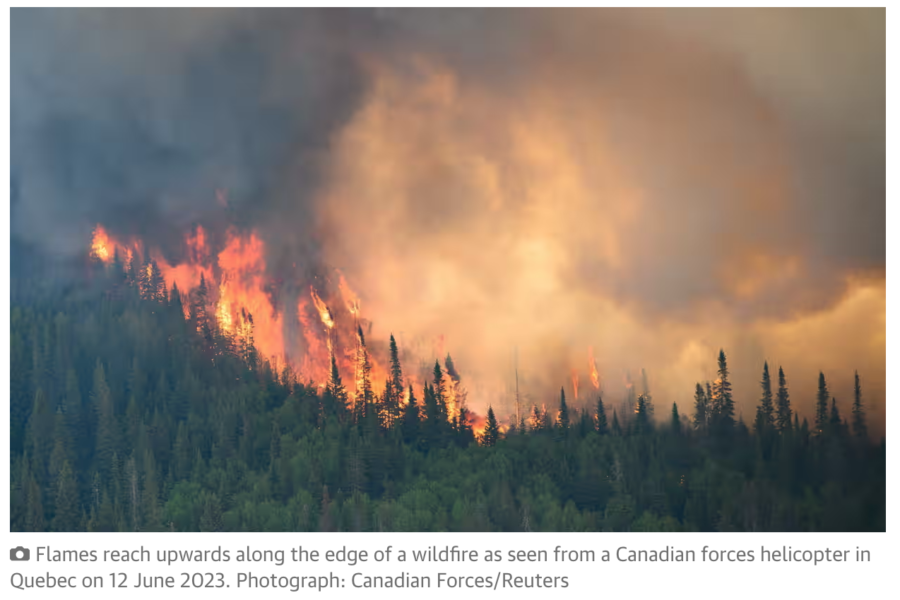
The Guardian reported that fighting that fire drew resources away from some of the nearly 700 fires in the province last summer. Most of those fires were ignited by lightning. The largest fire set by Paré, the Lake Cavan Fire, was one of the first in a series of five that he set between May 31 and June 1 just days after the provincial government had issued a ban on open fires because of dry weather conditions and fire danger.
Provincial police and first responders noted that some of the fires had no possible natural cause, and evidence indicated that some of the fires were intentionally set. Police first spoke to Paré on June 2; he had been seen in the area near a fire’s ignition point, and was considered a witness. Though he denied starting the fires, Charron said Paré demonstrated interest in fires in an interview, which led police to suspect him.
And that month he began posting on facebook about Quebec’s record-breaking season; among his posts were claims that the fires were intentionally set by the government to trick people into believing in climate change. Police set a tracking device on Paré’s vehicle, and it tracked him at locations where other fires were ignited.
Paré was arrested on September 7 and admitted to starting nine of the fires. He said he was doing tests to learn whether the forest was really dry or not, according to the prosecutor.