


(UPDATED at 9:39 a.m. PDT August 20, 2016)
There was very little growth of the Blue Cut Fire on Friday. As on Thursday, the east side of the fire was fairly quiet, while there is still fire activity on the west side, especially east and southeast of Wrightwood.
The incident management team is calling it 37,020 acres. On Saturday morning they revised upward the estimate of the number of structures destroyed, to 105 homes and 213 minor structures. Some evacuations are still in place.
****
(UPDATED at 4:15 p.m. PDT August 19, 2016)
CAL FIRE Public Information Officer Daniel Berlant reported this afternoon that Damage Assessment Teams estimate that 96 homes and 213 outbuildings have been destroyed in the Blue Cut Fire.
The fire has burned approximately 39,000 acres north of San Bernardino, California, according to the incident management team.
****
(UPDATED at 7:55 a.m. PDT August 19, 2016)
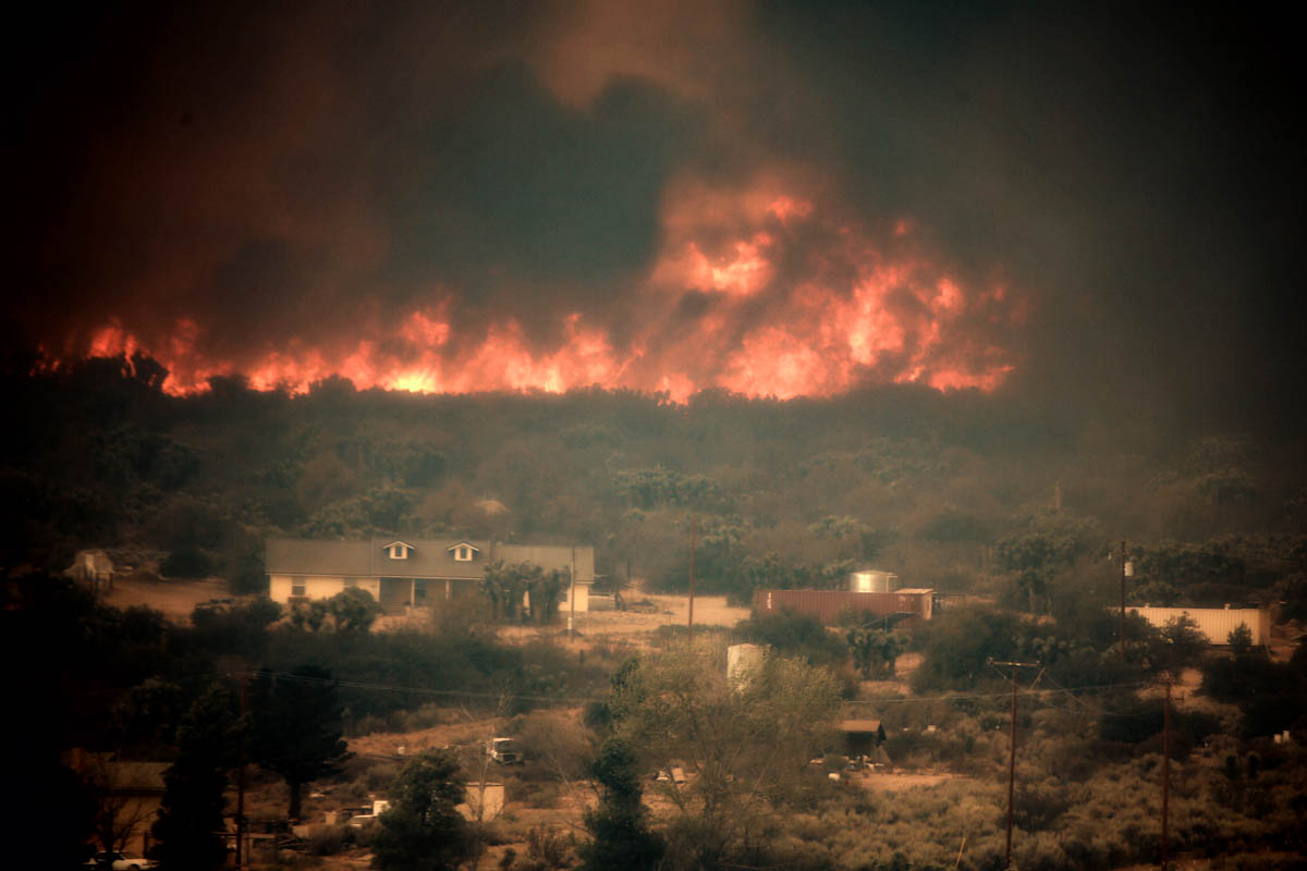
On Thursday the spread of the Blue Cut Fire north of San Bernardino in southern California was limited to the west side. According to the incident management team led by incident Commander Rocky Opliger, the growth added about 5,300 acres, bringing the total up to 39,000 acres.
The expansion occurred:
- on the north side in the flats southeast of Phelan,
- east of Wrightwood near Highway 2,
- in the remote mountainous area on the west side, and
- near Lytle Creek on the south side of the fire.
The east side of the fire has been relatively quiet for a couple of days.
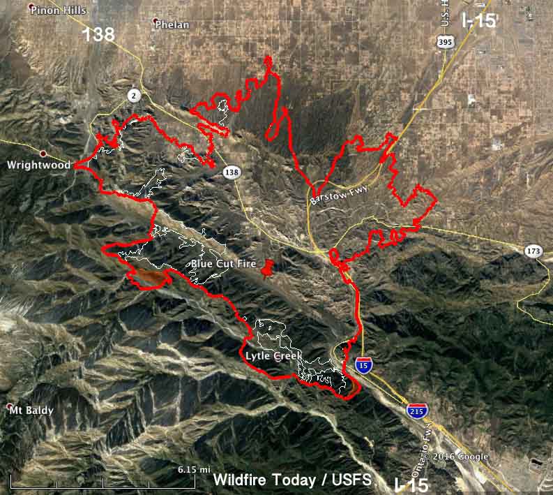
A Red Flag Warning is in effect for the fire area Friday until 9 p.m. this evening for 15 to 25 mph southwest to west winds gusting to 35 mph during the afternoon and evening. Relative humidities will be 10 to 15 percent.
The fire started August 16 and grew to tens of thousands of acres quickly. Numerous structures were seen burning on live television, but no information has been released about how many were affected.
The incident management team expects the fire will continue to move to the north, northwest and northeast towards Wrightwood, Victor Valley, Phelan, Baldy Mesa and South Hesperia. Evacuations are still in place.
****
(UPDATED at 7:43 a.m. PDT August 18, 2016)
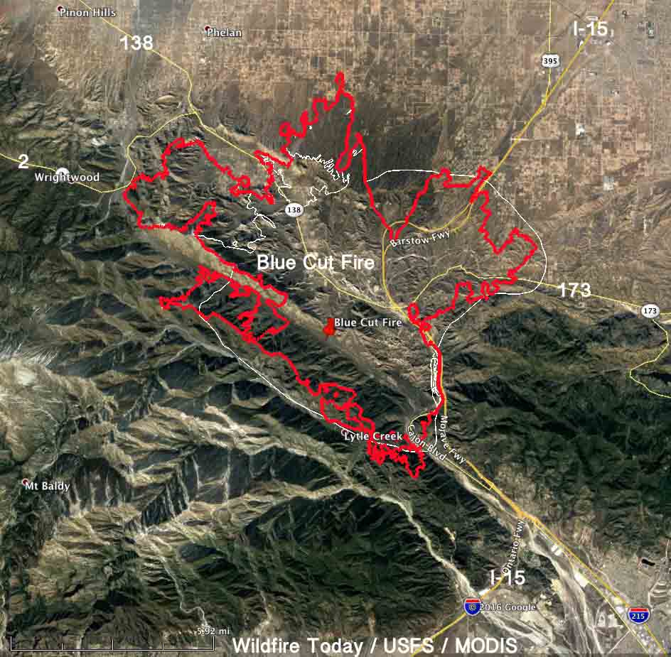
The Blue Cut Fire northwest of San Bernardino continued to spread Wednesday. The additional growth was on the northwest side where it reached Highway 2. And, on the north side it expanded a small amount at the base of the mountains and in the high desert flats toward Phelan. Evacuations are still in effect.
More accurate mapping on Wednesday resulted in the incident management team reducing the mapped size from 30,000 to 25,626 acres. After the growth of the fire yesterday, this morning they are calling it 31,689 acres.
Northbound Interstate 15 has reopened, but the southbound lanes are still closed. CALTRANS information about road conditions. UPDATE at 11:42 a.m. PDT August 18, 2016: Southbound I-15 is now open also.
#BluecutFire making a hard run along highway 2 near Wrightwood. pic.twitter.com/qGyTyRhGMo
— Randy Johanson (@epn424) August 18, 2016
SCE crews assisted firefighters and resolved electrical hazards at the #BlueCutFire in San Bernardino County @SCE pic.twitter.com/FEjBe4UtGF
— Ed Sherman (@fireimages) August 18, 2016
****
(UPDATED at 10:18 p.m. PDT August 17, 2016)
The U.S. Forest Service has reduced the reported size of the Blue Cut Fire northwest of San Bernardino. At about 7 p.m. Wednesday they said more accurate mapping shows that it is now at 25,626 acres, down from the 30,000 figure released about 12 hours previously. They did not specify when that new assessment was valid — if it was based on a perimeter from Tuesday night, Wednesday afternoon, or some other time.
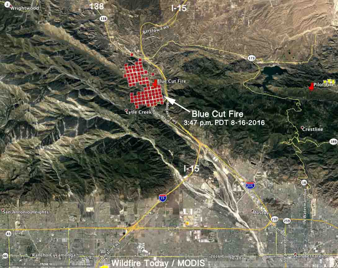
It had occurred to us that many sections of the perimeter were depicted as being too smooth and straight, rather than almost randomly jagged like the northwest section that was mapped by an infrared aircraft Tuesday night. (This comes from a guy, moi, who used to spend a lot of time mapping fires.) Since that IR flight the fire has grown by at least several thousand acres as shown in the satellite data in the map below. There is a report that it has either reached Highway 2 on the northwest side, or firefighters are burning out from that highway.
#BluecutFire update in acreage do to more accurate mapping. Now at 25,626; 1584 personnel on scene
— San Bernardino NF (@SanBernardinoNF) August 18, 2016
****
(UPDATED at 4:40 p.m. PDT August 17, 2016)
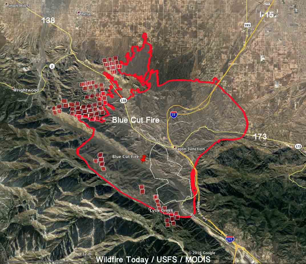
When a NASA satellite flew over the Blue Cut Fire at 1:30 p.m. PDT on Wednesday, it detected additional fire growth beyond the perimeter that was mapped at 11 p.m. PDT on Tuesday. The red squares on the map above outside the red line represent approximately 2,500 acres. Early Wednesday morning the incident management team was calling it 30,000 acres.
The additional growth was on the northwest side spreading toward Wrightwood and Phelan, and on the south side near Lytle Creek.
****
(UPDATED at 7:31 a.m. PDT August 16, 2016)
The U.S. Forest Service reports that the Blue Cut Fire at Cajon Pass has now burned 30,000 acres.
****
(UPDATED at 7:20 a.m. PDT August 17, 2016)
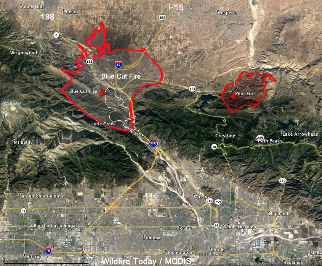
The Blue Cut fire continued to spread aggressively as darkness fell Tuesday night forcing 82,000 residents to evacuate. The fire started at in Cajon Pass near Interstate 15 at about 10:30 a.m. on Tuesday and rapidly spread into the brush. It is now 13 miles northwest of San Bernardino and has threatened the communities of Lytle Creek, Wrightwood, Baldy Mesa, Phelan, and Hesperia.
In addition to Interstate 15 the fire has crossed Highways 138 and 173. Officials closed I-15 and Highway 138, which made it difficult for residents to evacuate.
The live streaming video shown by Los Angeles television stations Tuesday included images of multiple structures that were destroyed including the Summit Inn, a well known local landmark along Interstate 15 in Cajon Pass.
At about 11 p.m. on Tuesday the U.S. Forest Service said the size was estimated at 18,000 acres, but with the data from an overnight mapping flight it is likely that an update Wednesday morning will put it at closer to 25,000 to 30,000 acres.
The weather forecast for Wednesday, which includes a Red Flag Warning, is not good news for firefighters. The temperature will be in the high 90s, the relative humidity will be 3 to 10 percent, and the wind for the next two days will be out of the south at 10 to 20 mph (depending on the exact location and day/night) with gusts of 20 to 30.
The Fire Behavior Analyst on the fire said “the brush is extremely dry, basically dead”.

#BreakingNews Historic Route 66 landmark Summit Inn in Hesperia burns #bluecutfire pic.twitter.com/VktmYoplTy
— CBS Los Angeles (@CBSLA) August 17, 2016
Blue Cut gets its name from the railroad cut through the Pelona Schist #BlueCutFire pic.twitter.com/FGMQNns5Y4
— Andrew Alden (@aboutgeology) August 17, 2016
Spotted: A melted McDonald’s sign. #BlueCutFire updates: 30,000 acres burned, 0% contained https://t.co/FudxJGJAVL pic.twitter.com/FLXHjVa0zS
— Los Angeles Times (@latimes) August 17, 2016
****
(UPDATED at 8:41 p.m. PDT August 16, 2016)
CAL FIRE reports the Blue Cut Fire in Cajon Pass in southern California has grown to 15,000 acres.
The USFS reported that on the Blue Cut Fire today six firefighters became entrapped while defending homes and assisting evacuations in the Swarthout Canyon area west of Cajon Pass. The six firefighters were part of two San Bernardino County Fire engine companies assigned to the area northwest of Cajon Blvd.
The firefighters were able to shelter in place within a nearby structure, but two firefighters sustained minor injuries. Both firefighters were transported to a local hospital where they were treated and released and are now back on the fire line defending structures. One SBCoFD fire engine sustained moderate fire damage.
****
(UPDATED at 7:18 p.m. PDT August 16, 2016)
The Blue Cut Fire that started in Cajon Pass in southern California adjacent to Interstate 15 has continued to grow rapidly and is now estimated at 9,000 acres. There is imminent threat, the US Forest Service says, to public safety, rail traffic and structures in the Cajon Pass, Lytle Creek, Wrightwood, Oak Hills, and surrounding areas.
Evacuations are in effect for 34,500 homes and 82,640 residents.
Interstate 15 is closed in both directions.
#BlueCutFire: this dog is waiting outside his home that is now burning near Phelan @KTLA #KTLA pic.twitter.com/UoShj0Rcol
— Kirk Hawkins (@kirkhawkins) August 17, 2016
****
(UPDATED at 6:05 p.m. PDT August 16, 2016)
At 5 P.M. the USFS reported that the Blue Cut Fire was 6,500 plus acres with 700 personnel on scene, 57 engines, 8 crews, 8 air tankers, and 2 Very Large Air Tankers (DC-10s). Additional firefighters and equipment are on order.
****
(Originally published at 2 P.M. PDT August 16, 2016)
The Blue Cut Fire started in Cajon Pass west of Interstate 15 at about 10:30 a.m. on Tuesday and rapidly spread into the brush. The Interstate is closed in both directions.
Several media outlets are reporting that one or possibly two fire engines were overrun by the fire and the firefighters left the trucks to take refuge in nearby residences. There are reportedly no injuries but ambulances were seen near one of the engines in live video of the fire.
The San Bernardino National Forest reports that there have been two minor injuries to firefighters. It is unknown if the injuries were related to the burnover of the engines.
The San Bernardino County Sheriff has declared a mandatory evacuation for all residents in the community of Lytle Creek which is on the west side of I-15.
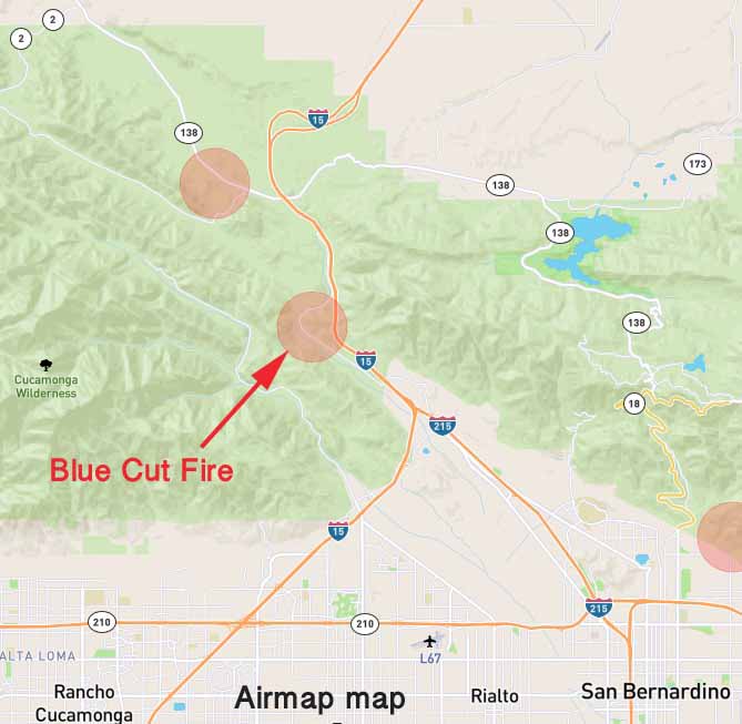
NBC Los Angeles and ABC7 occasionally have streaming live video of the fire.
A freight train in Cajon Pass stopped and the crew evacuated, according to NBC Los Angeles. There is no report of the cars on the train burning.
Cajon Pass is infamous for frequent fires and strong winds that spread the fires rapidly.
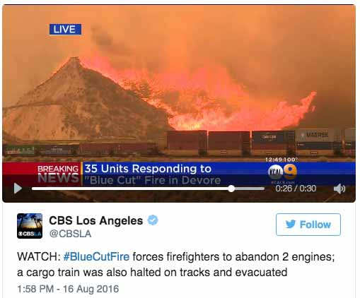
The latest size being reported is 1,500 acres.
The relative humidity in the fire area Tuesday afternoon has ranged from 3 to 7 percent, according to the meteorologist for NBC Los Angeles.


Thanks and a tip of the hat go out to Tom.


