


(UPDATED at 7:27 p.m. PDT, May 15, 2014)
The fire is still reported to be 6,000 acres. A Type 2 Incident Management Team, with Incident Commander Garwood, is on scene.
****
(UPDATED at 8:59 p.m. PDT, May 14, 2014)
CAL FIRE reported at about 8 p.m. that the fire was 6,000 acres. It spread from the Naval Weapons Station near Fallbrook onto Camp Pendleton.
****
(UPDATED at 4:40 p.m. PDT, May 14, 2014)
A change in wind direction has resulted in Fallbrook having an increased threat from the Tomahawk Fire that started just west of the community on Camp Pendleton. The wind is now from the west and southwest pushing the smoke, and possibly the fire, closer to the town.
CAL FIRE reports that the Tomahawk fire has burned 150 acres, and the Highway fire, near Interstate 15 and SR-76 has blackened about 600 acres with no containment. Evacuations are taking place in the area of the Tomahawk fire.
The Southern California Geographic Area Coordination Center reported at 4 p.m. that Interstate 15 is closed from 3.5 miles south of the junction of SR76 to 0.7 miles north of the junction of SR76 (San Diego County) as of 3:27 p.m. due to a wildfire. Possibly the Highway Fire which started near the intersection of I-15 and SR-76 is the culprit in the freeway closing issue. However, by 4:40 p.m. the Interstate reopened.
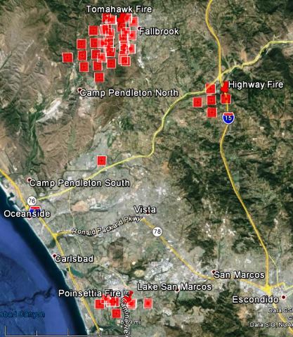
The updated map below shows the spread of the Highway, Tomahawk, and Poinsettia Fires.
****
(UPDATED at 3:04 p.m. PDT, May 14, 2014)
The size of the Tomahawk Fire near Fallbrook on the east side of Camp Pendleton is now estimated at 150 acres.
A third fire in San Diego County, the Highway Fire seen in the photo below, is being fought by firefighters near the intersection of Interstate 15 and SR76. It started at about 1 p.m. and by 1:45 it had burned about 30 acres according to CAL FIRE.

****
A new fire on the east side of Camp Pendleton near Fallbrook, California is growing rapidly and threatening the DeLuz housing area. The map, below shows the approximate location of the Tomahawk fire that started at 9:40 Wednesday morning.

There could be shortages of firefighting resources, since at least two other fires in the area also have to be staffed by firefighters and aircraft. The Bernardo Fire north of San Diego started Tuesday and burned about 1,500 acres before the winds died down in the evening. Another fire that started Wednesday morning, the Poinsettia Fire in Carlsbad, is also very active and is threatening structures and causing evacuations.
We will update this article as more information becomes available today.







