


7:30 p.m. PDT, Aug 5, 2021
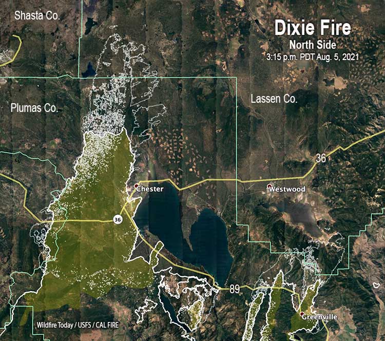
The spread of the Dixie Fire Thursday was made more complex and unpredictable by the passage of a weather trough. It hit the fire area in the afternoon and brought a significant change in the wind, shifting it from the south or southwest to come out of the west or west-northwest. This may not seem like a huge difference, but wind is the primary factor affecting the direction of spread of a vegetation fire. A 90-degree change in wind direction can turn the flank of a fire into the head. Next to the heel or back of a fire, the flank can sometimes be a somewhat safe place from which to attack a fire, unless it burning in extremely dry vegetation pushed by strong winds. (Which is often the case over the last several years.)
To see all articles on Wildfire Today about the Dixie Fire, including the most recent, click HERE.
Radar that was detecting smoke showed the wind shift in real time Thursday afternoon.
Wind shift occurring now on #DixieFire as trough moves overhead, putting additional towns in danger. Plume shift visible from KDAX radar. pic.twitter.com/BLMlWknblV
— Courtney Carpenter (@CourtECarpenter) August 5, 2021
Firefighters who were on the right flank of the Dixie Fire today were no doubt warned by their Incident Meteorologist to expect the east flank Thursday afternoon to become the head of the fire, moving east quickly in their direction pushed by strong winds.
Westwood is a community of about 1,600 residents on Highway 36, 11 miles north of Greenville and 11 miles east of Chester. If the fire moves north from Greenville it will be threatened, and, if it moves east from Chester, it will be threatened.
By 3:15 p.m. Thursday the Dixie Fire, after destroying many of the structures in Greenville, had continued to spread 6 miles further north from the town. With long range spotting it reached Mountain Meadows Reservoir. If it finds a way around it, another 5 miles with a south or southwest wind and it could be at Westwood.
Another danger to Westwood is the northwest portion of the fire that burned over the Chester airport Wednesday and continued north during the night and Thursday, chewing through another 14 miles of forests. It looks like those 14 miles of the east flank could become a 14-mile wide head fire at least for a short time if the forecast pans out as expected.
The prediction for the Westwood area Thursday was for the winds to change direction in the afternoon to come out of the west at 13 mph with 21 mph gusts. The good news is the period of strong winds will be brief. At 8 p.m. it should decrease to 6 mph but still be from the west, and by 11 p.m. slow to 2 mph.
Obviously, Westwood is under a mandatory evacuation order by the Lassen County Sheriff’s office. (More information about evacuations.)
Keep the firefighters and the residents in your thoughts.
9:10 a.m. PDT Aug. 5, 2021

Many, if not most of the structures along the highway 89 corridor through Greenville, California were destroyed Wednesday when the Dixie Fire rapidly spread through the town 57 air miles northwest of Oroville. Structures in other areas of Greenville also burned, but firefighters were able to save some.
The fire has now burned approximately 322,000 acres.

The fire crossed Highway 89 in half a dozen places Wednesday between Greenville and Chester, burning to the shore of Lake Almanor in several locations. It also jumped indirect firelines south of Highway 36 and not slowed, was eight miles north of the highway, burning fiercely during an 11:45 p.m. mapping flight. There are indications from satellite imagery at about 3 a.m. Thursday, not yet confirmed, that it had grown an additional five miles north in that three-hour period, aided by long-range spotting.
To see all articles on Wildfire Today about the Dixie Fire, including the most recent, click HERE.

The Dixie Fire mostly skirted around the west side of Chester after burning around the airport runways. We have not seen any reports of extensive damage in that area — yet.

Unfortunately, the #DixieFire destroyed most of #greenville today. More pix here: https://t.co/zpEFuvqu7N @AFPphoto pic.twitter.com/qhgKKgJvpW
— Josh Edelson (@JoshEdelson) August 5, 2021
Central Greenville after the Dixie Fire tore through this afternoon. #DixieFire (last five are Chester earlier in day)https://t.co/SxOip3W0kc
— Noah Berger (@noahberger3884) August 5, 2021
11:31 p.m. PDT August 4, 2021

Strong winds, low humidity, and dry vegetation helped push the northeast side of the Dixie Fire through Greenville, California and across Highway 89 in several places Wednesday afternoon. It was really bad news for many of the residents and business owners, as documented by reporters who entered the town after the worst of the fire passed over after having destroyed multiple structures.

Data from a 6:50 p.m. mapping flight Wednesday showed that the northwest side of the fire was even more violent, raging in the wind, spreading for five to eight miles to the north-northeast, running along the shore of Lake Almanor, crossing Highway 36, burning around the runways at the airport, and skirting around the west side of Chester.
Wednesday’s Red Flag Warning will continue until Thursday evening. The forecast for Chester on Thursday calls for 79 degrees, 10 to 14 mph winds in the afternoon out of the southwest gusting to 21 mph, and relative humidity in the low teens. The weather combined with low fuel moisture and the Energy Release Component at Quincy which is above the 97th percentile, will make it another day that fire behavior will challenge firefighters.


