


(UPDATE at 8:40 a.m. MDT July 15, 2016)
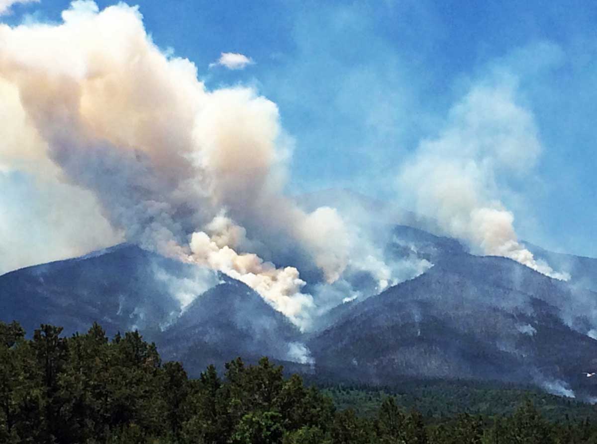
The Hayden Pass Fire near Coaldale, Colorado grew by about 1,000 acres on Thursday and has now burned approximately 15,700 acres.
The incident management team reported Thursday night that they received more helicopters and seemed to imply that suppression of the fire had been hampered by a shortage of aircraft:
Additional helicopters arrived, enabling firefighters to utilize seven ships this afternoon, performing water drops and vital reconnaissance for fires that begin outside the fire perimeter.
Evacuations, road, area and trail closures are in effect and one structure has been destroyed.
The fire has spread south towards the Lake Creek drainage and west of the Duckett fire scar of 2011. Structural protection teams are installing sprinkler systems and removing vegetation around some structures out ahead of the fire.
The weather forecast for the Coaldale area for Friday and Saturday predicts temperatures in the low to mid-80s, southwest winds at 8 to 10 mph, and relative humidities in the low teens with very little chance of rain. Parts of Colorado will be under Red Flag Warnings or Fire Weather Watches Friday and Saturday.
****
(UPDATE at 1:30 p.m. MDT July 14, 2016)
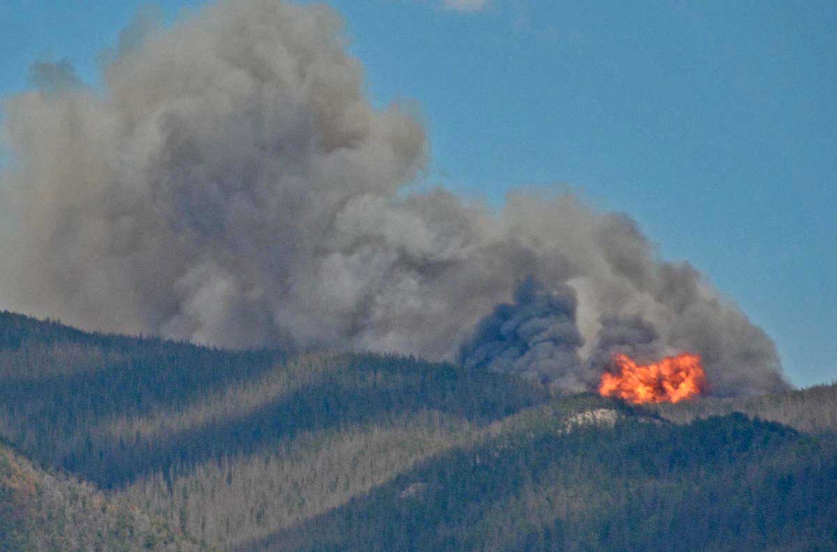
The incident management team for the Hayden Pass Fire issued the information below as part of a Thursday morning update:
…Crews are actively suppressing the fire outside of the Sangre de Cristo Wilderness utilizing structure defense, direct and indirect fire control strategies. Helicopters and air tankers are supporting these strategies, to include retardant drops for structural protection. Firefighting resources are shifting as priorities are completed and new risks are prioritized. Firefighters will continue to suppress the fire using resources and tactics to minimize firefighter risk with the highest probability of success.
The fire continues to burn in the Sangre de Cristo Wilderness. Crews are not currently engaging the fire within the wilderness due to complex terrain causing safety concerns; rather, they will closely monitor fire movement and assist Forest Service staff by informing recreationists of area closures…
The update on the fire posted today at InciWeb did not include the revised size of the fire. Members of the media who attended a press conference this morning reported it had grown to more than 14,500 acres.
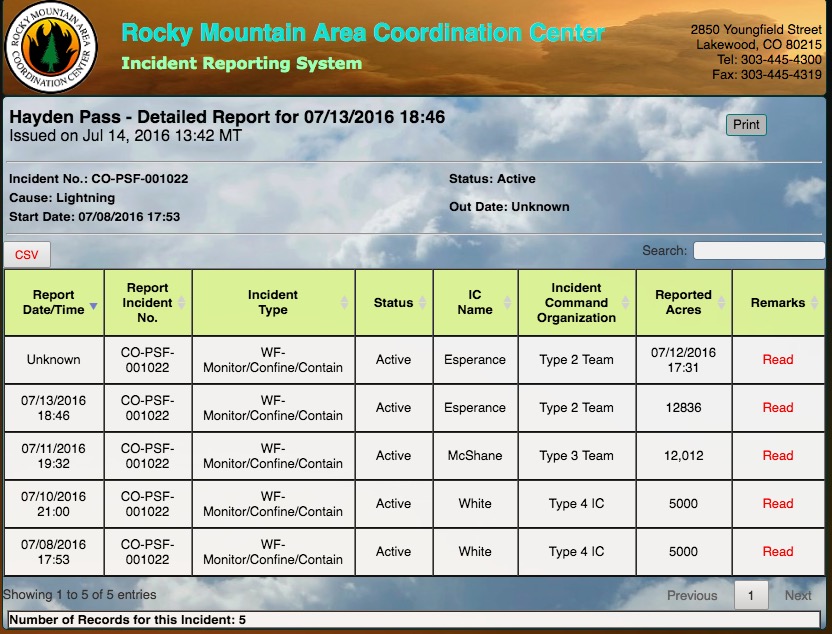
The way the U.S. Forest Service describes the management strategy of these less-than-full-suppression wildfires is confusing — to the public and even some firefighters. Officially the Hayden Pass Fire is listed as a “monitor/confine/contain” fire rather than “full suppression” like most fires. But the agency and the Information Officers communicating with citizens do not like to discuss that publicly. It can be scary to some when they hear that the government is not pulling out all the stops in order to put out a fire quickly. And it can be disconcerting to think about a fire within sight of hundreds of homes burning from early July until October 1, which is the “completion” date for the Hayden Pass Fire listed in the excerpt below from the National Situation Report. (See “Cnt/Comp” which refers to Contain or Complete, with Contain being suppression, and Complete referring to less-than-full-suppression.)


Below are two video briefings that were posted on Thursday. The first features Incident Commander Jay Esperance. Following that is Operations Section Chief Travis Lipp. Click on the full screen icons to see larger versions.
****
(UPDATE at 21:20 p.m. MDT July 13, 2016)
At a 10 a.m. press briefing today a spokesperson for the Hayden Pass Fire said it grew yesterday by about 600 acres to just under 13,000 acres
****
(UPDATED at 8:20 a.m. MDT July 13, 2016)
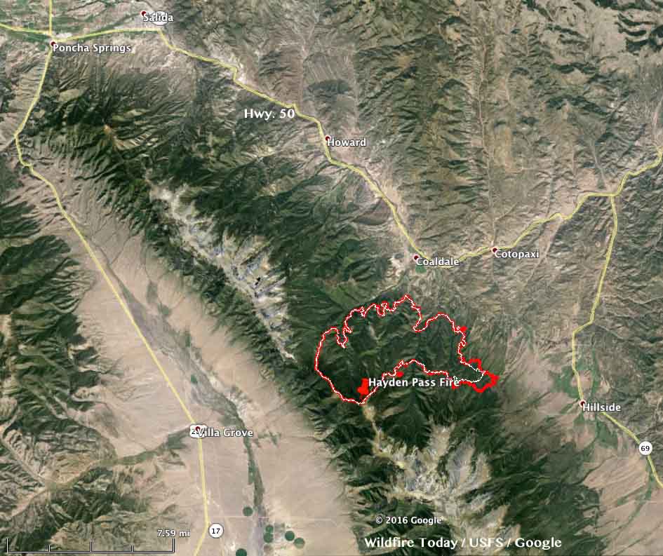
The Hayden Pass Fire 17 air miles southeast of Salida, Colorado added less than 1,000 acres on Tuesday mostly through activity on the southeast side but also on the north side. Dozers constructed fireline from Hayden Creek toward Big Cottonwood drainage while a hotshot crew built line from Big Cottonwood drainage toward Hayden Creek and the dozer line. Aircraft were used in those areas to slow the fire and support firefighters on the ground.
The fire is still 1 to 2 miles southwest of Coaldale.
The weather on Wednesday could be conducive to additional fire spread. The forecast for the fire area 3 miles south-southwest of Coaldale predicts 85 degrees, relative humidity in the low teens, and a west wind at 10 to 13 mph.
Evacuation information is at the Fremont County Sheriff’s Facebook page.
****
(UPDATED at 8:56 p.m. MDT July 12, 2016)
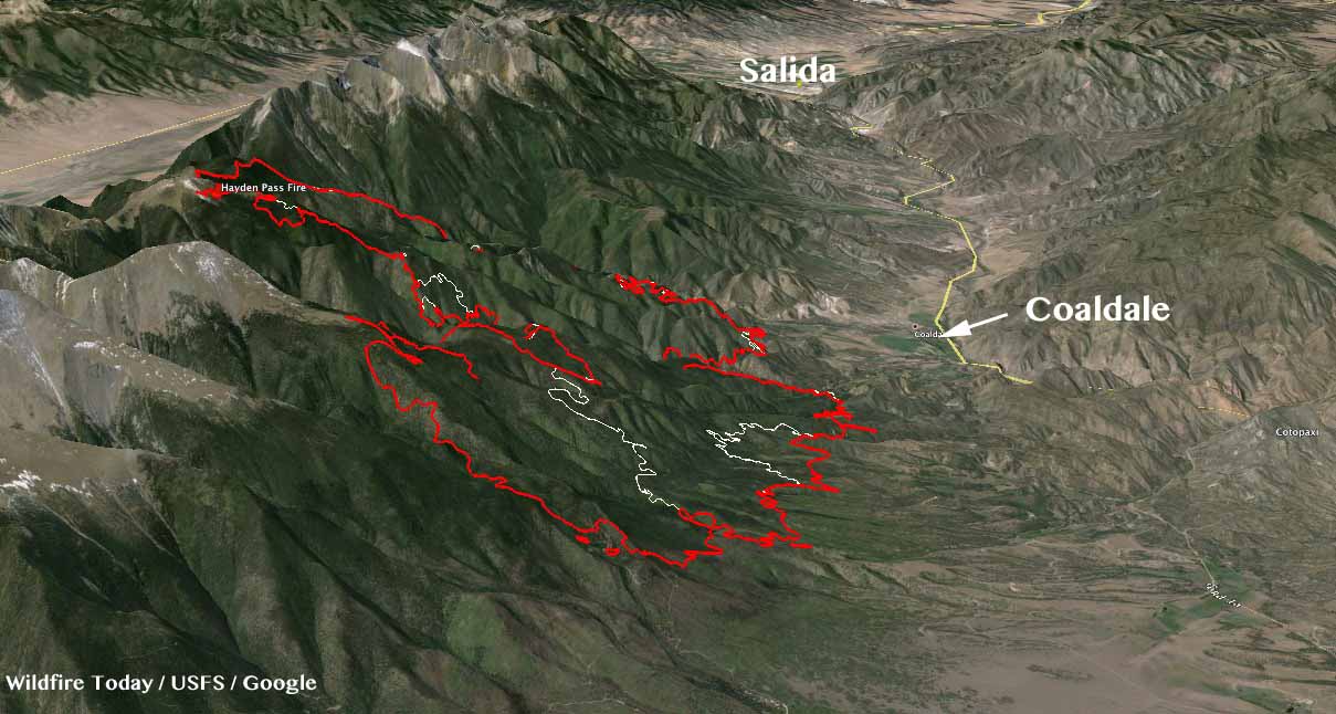
Judging from the state of the Hayden Pass Fire at 2:04 p.m when the heat-sensing satellite took a look at it, the blaze was much more sedate than the previous two days. However at that time there were several hours left in the most intense part of the burning period and it could have become more active for a few hours. The satellite at 2:04 p.m. only detected one area where the fire was actively spreading, the extreme southeast corner. In the map below from Monday night at 10 p.m., it would be the tip of the red perimeter at the bottom of the map. (The 3-D map is looking toward the northwest.)
****
(UPDATED at 9:34 a.m. MDT July 12, 2016)

The spread of the Hayden Pass Fire southeast of Salida, Colorado slowed Monday evening after the wind diminished. As recorded by a weather station at Salida, from 9 a.m. until around sunset a strong 15 to 30 mph west wind pushed the fire with gusts of 24 to 36 mph. After midnight it was only blowing at zero to 7 mph while the temperature dropped to 50 degrees and the relative humidity increased to 48 percent.
The fire was reported Friday, July 8 and has grown substantially toward the east and southeast over the last 36 hours. So far it has burned in high elevation unpopulated areas and no homes have been destroyed, but it has spread into the lower elevations and could move closer to Coaldale and Highway 50 on Tuesday. Monday evening the fire was mapped at 12,012 acres.
Evacuation information is at the Fremont County Sheriff’s Facebook page.
The burning conditions on Tuesday will be much more benign than firefighters have seen over the last two days. The forecast for the fire area calls for 82 degrees, southwest and west winds of 8 to 10 mph, mostly clear skies, and almost no chance of rain.
The fire is about 1.6 miles southwest of Coaldale and 17 miles southeast of Salida.

As of 6 a.m. today the fire is being managed by the Rocky Mountain Incident Management Blue Team, with Incident Commander Jay Esperance.
UPDATE: #HaydenPassFire grows to 12,000 acres Monday; mandatory evacuations ordered: https://t.co/OmrDbfgdqr pic.twitter.com/6izzgg2qFz
— The Denver Post (@denverpost) July 12, 2016
****
(UPDATED at 6:12 p.m. MDT July 11, 2016)

The Hayden Pass Fire 19 miles southeast of Salida, Colorado has been very active over the last 12 hours, adding several thousand acres to its total. Our very rough, unofficial estimate puts it at about 8,000 acres as of 2:23 p.m. July 11, 2016. At 5:30 p.m. a spokesman for the Bureau of Land Management Front Range District reported it was approximately 10,000 acres at that time. The good news is that no structures have burned.
Mandatory evacuations are still in place.

Fire spokesperson: Aircraft has been diverted to other fires. Requests in, but no aircraft received. #HaydenPassFire
— Emily Allen KRDO (@EmilyAReports) July 11, 2016
The 747 Supertanker based in Colorado Springs has not received certification from the Interagency AirTanker Board, so it can’t be used on federal fires. A decision from that Board, however, does not affect state or county agencies, which could contract for the aircraft. But at this time it is down to repair damage caused by hail.

****
(UPDATED at 3:55 p.m. MDT July 11, 2016)

The GOES East satellite easily detected smoke from the Hayden Pass Fire on Monday afternoon.
****
(Originally published at 1:25 p.m. MDT July 11, 2016)

The Hayden Pass Fire that started July 7, 2016 19 miles southeast of Salida grew substantially overnight. Our very unofficial estimate based on heat detected by a satellite indicated that it had burned approximately 5,000 acres as of 3:05 a.m. on July 11 and was about 3 miles southwest of Coaldale. At that time the fire was very active. KKTV reported at 1 p.m. today that the U.S. Forest Service estimated the size at 7,500 acres.
As of noon, here’s the updated #HaydenPassFire evacuation map: pic.twitter.com/l7WizzIrgA
— Barrett Tryon KKTV (@btryn) July 11, 2016
The fire started on the San Isabel National Forest and spread into the Sangre de Cristo Wilderness on the Rio Grande National Forest.

The area is under a Red Flag Warning on Monday. The weather forecast for the fire area for Monday is not favorable for the firefighters. It predicts 82 degrees, a 22 mph wind out of the west, and relative humidity of 14 percent. The prediction for Tuesday is not as severe.

#haydenpassfire has come over a ridge and massive flames and smoke pic.twitter.com/nkYJmDbLjf
— Adam Knapik (@adamknapik) July 11, 2016
View of #HaydenPassFire from San Luis Valley side of mtn from my friend Debbie. Insane smoke- #wildfire @CBSDenver pic.twitter.com/ApSxsiFHkt
— Matt Kroschel (@Matt_Kroschel) July 11, 2016


