


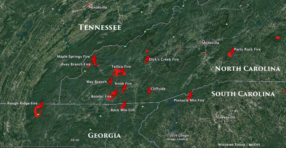
Above: The map shows the location of some of the larger wildfires in North Carolina, South Carolina, and Georgia November 11, 2016.
(UPDATED at 4:59 p.m. ET November 11, 2016)
The intense wildfire activity that has been going on for weeks in the southeast United States ramped up a bit over the last 24 hours as extremely low relative humidities allowed some of the blazes to continue to spread aggressively Thursday night. A weather station southeast of Asheville, NC 9 miles northwest of the 977-acre Party Rock Fire recorded 9 percent RH early Friday morning. Night time humidities in that part of the country are usually far above 50 percent at night.
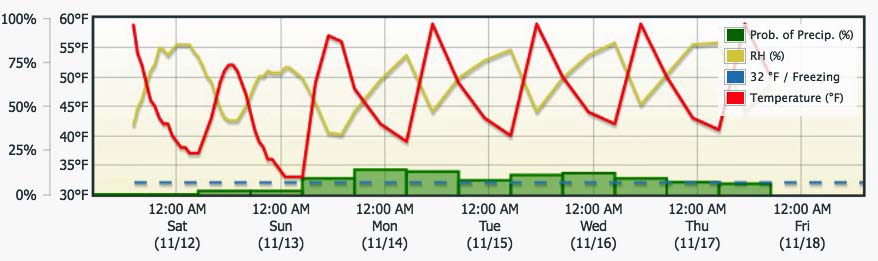
The good news is the conditions will moderate a little over the next several days after the passage of a cold front.
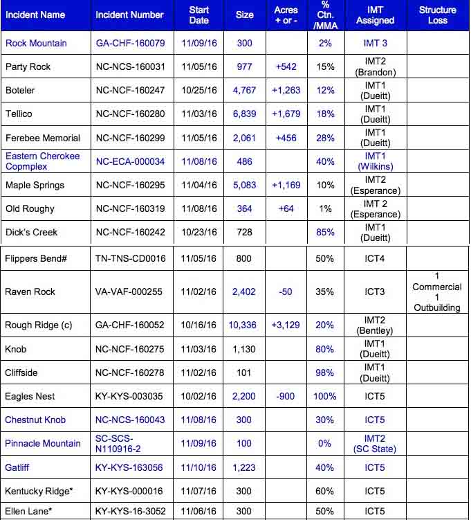
There are currently 31 uncontained wildfires in the Southern Geographic Area. Here some other numbers about the fires in the region (data from the National Interagency Coordination Center and the Southern Area Coordination Center):
- 10 Incident Management Teams deployed or en route (3 Type 1 teams, 6 Type 2 teams, and 2 Type 3 teams)
- 77,507 acres have burned in the fires that are still active
- 136 hand crews
- 184 engines
- 12 air tankers (4 large and 3 single engine)
- 14 air attack ships
- 34 helicopters (11 large Type 1, 5 medium Type 2) and 18 Type 3)
- 3,067 total personnel assigned
Fire behavior on the fires continues to be extreme. The Energy Release Component percentiles are above the 90th percentile throughout the region and many areas are setting record high values for this time of year. The 1,000 hour time-lag fuel moistures are below the third percentile. The Keetch-Byram Drought Index values are above the 97th percentile.
And, during this period of unusually dry weather, crews and engines continue to be in short supply and in very high demand.
Evacuations are currently underway at the Party Rock Fire near Chimney Rock, 18 miles southeast of Asheville, NC.
Here are a few details about other fires:
- Rock Mountain Fire: in northeast Georgia, 8 miles west of Dillard. 300 acres; 42 structures threatened; 40 personnel assigned.
- Boteler Fire: 4,767 acres; 6 miles east of Hayesville, NC; 314 structures threatened; 538 personnel assigned; costs to date $3.1 million.
- Tellico Fire: 6,839 acres; 3 miles south of Almond, NC; 137 personnel assigned; 336 structures threatened.
- Maple Springs: 5,083 acres; north of Santeetlah Lake in North Carolina; 29 structures threatened; 192 personnel assigned.
- Rough Ridge: 10,336 acres; 13 miles west of Blue Ridge, Georgia; 48 structures threatened; 227 personnel assigned.
We had hoped to get an updated satellite photo showing smoke from the fires, but Friday afternoon’s overflight shows mostly clouds. However there appear to be some streaks of smoke blowing into northwest South Carolina between Charlotte and Greenville.

For the latest articles at Wildfire Today about wildfire smoke check out the articles tagged “smoke”.


