


When a group of firefighters from North America arrived in Australia earlier this year to assist with an exceptionally large number of bushfires, one of them was quoted by a local media outlet as saying, “I understand it’s pretty traumatic for you guys, but it’s something we deal with – it’s our comfort zone”. It was not clear to whom the firefighter was speaking, civilians or in-country firefighters, but it struck me as a little odd and could be interpreted as patronizing from someone who had been in the country for less than a day.
Make no mistake, Australians have been dealing with vegetation fires as long as the North Americans have, and their blazes can be just as calamitous as those on the other side of the equator. Firefighters on both continents can learn from each other. From my limited vantage point 8,000 miles away it is clear that Aussies do a lot of things very well, especially designing their fire engines and keeping the public informed about the status of active fires.
In the United States if a citizen needs current information about a wildfire how do they get it? The local sheriff, local fire department, or a state agency? It makes a difference about where to look if the fire is on federal land, state protected land, city, county, national or state park. If they try social media, what account? InciWeb sometimes has information about wildfires managed by federal agencies, but not all. Information about individual fires may not have been updated for 12 to 18 hours, however some incident management teams are better than others. And evacuations are managed by local law enforcement. When someone is threatened by a rapidly spreading wildfire they don’t have time to randomly check an alphabet soup of acronyms on dozens of web sites or social media accounts, even if they know the names, handles, or web addresses.
The map below is an example of something done very well in Australia. In New South Wales the Rural Fire Service distributes a great deal of current information to the public through Twitter, Facebook, and their web site.
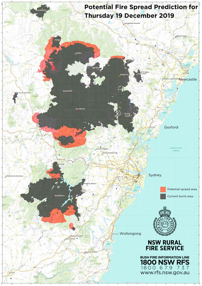
Advice – Green Wattle Creek (Wollondilly LGA)
Extreme Fire Danger is forecast for this fireground on Thursday 19th December 2019. Conditions will be dangerous due to high temperatures, strong and gusty winds and low humidity. This potential fire spread prediction map shows the communities that may come under threat from embers or fire fronts. Conditions are then forecast to worsen again on Saturday.
It would be very unusual for a firefighting agency in the U.S. to distribute to the public a map, like the one above, that showed projections of fire spread of two major fires over the next 24 hours. Most agencies in the U.S. are hesitant to even publicly predict the general direction a fire will spread, let alone a map showing the location and extent of where the fire is expected to be in a matter of hours.
The technology to produce maps like this exists, but depending on the accuracy needed, it can require a supercomputer to crunch the numbers. In September the Orange County Fire Authority in California began a 150-day pilot program to use and evaluate the Fire Integrated Real-Time Intelligence System (FIRIS). It utilizes a supercomputer at the University of California San Diego running WIFIRE spread projections based on fire perimeter data collected by an aircraft. The output estimates where the fire will be in the next six hours. It has been run on real fires a few times, with the latest being the Cave Fire at Santa Barbara, California.
Watch and Act – Gospers Mountain (Lithgow and Hawkesbury LGA)
Fire activity is increasing in the Berambing area. Monitor conditions and know what you will do if fire threatens. Take advice from firefighters working in the area. #nswrfs #nswfires pic.twitter.com/cdgsDN6VfO
— NSW RFS (@NSWRFS) December 17, 2019
Another area where the NSW RFS excels is posting aerial videos of active fires. The agency frequently puts them on Twitter and Facebook, giving the public a general idea of how actively the fire is burning. Many of them show air tankers and helicopters dropping water on the fires, showing taxpayers how their money is being spent.


