


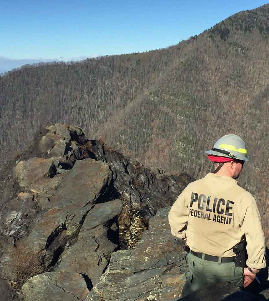
Above: Fire Management Officer Greg Salansky points toward the twin peaks (at upper left) where the Chimney Tops 2 Fire burned for five days before it spread into Gatlinburg, Tennessee. Photo by Bill Gabbert.
When a group of wildfire professionals visited Great Smoky Mountains National Park on June 7, Fire Management Officer Greg Salansky walked them through the steps he took in evaluating and managing the fire that after six days burned into Gatlinburg, Tennessee killing 14 people, forcing 14,000 to evacuate, destroying or damaging 2,500 structures, and blackening 17,000 acres. In addition to coordinating the wildland fire management activities at that park, Mr. Salansky does the same thing for 20 other National Park Service sites in the Southeast United States
Late in the afternoon on November 23, 2016 firefighters in the Park were responding to a report of a vehicle fire when they spotted a vegetation fire near the top of a steep hill called Chimney Tops. A fire in the same area a week earlier was given the name “Chimney Tops”, so this new fire became “Chimney Tops 2”.
Mr. Salansky and one firefighter hiked up a trail to the fire area but when they got close to the blaze in a very steep area the other firefighter decided that it was unsafe for her to continue so she remained at that location while Mr. Salansky continued. Working his way along a portion of the fire edge he found that the vegetation was very dense making travel through the steep, rocky terrain difficult.
He tried scraping some leaves to begin a fire line, but told the group last week standing in a pull-out on the highway looking up at Chimney Tops, “Well, maybe I can go in on the north side. So I walked that ridge and the smoke laid over about chest high. I’d get in about 20 feet and the wind would let up and the smoke would come up. There was a drop off on both sides. I did that a couple of times before I figured out I shouldn’t even be here. What am I doing here? So I thought I’m done, there’s nothing I can do with it. It’s dark. It’s not safe. So I bailed off and tied in with April who was my safety, since she was smart enough not to go where I went. So we hiked back down. We’ve got a squad coming in the next day, Thanksgiving, welcome to Thanksgiving day.”
The next day, November 24 (day #2), with about six other firefighters he hiked up near the fire that occurred a week before where there is a sign reading, “From this area past it is closed.” Mr. Salansky said. “There’s been one fatality and multiple injuries that cost like $20,000 apiece. So all the folks read that and they’re like, ‘It says it’s closed and dangerous and you want us to go in and fight fire.’ ”
They continued to scout the fire, including working through some rocky terrain after they left their packs behind to make it easier to climb through the rocks while carrying their firefighting tools. Mr. Salansky determined that some portions of the fire edge were “unnavigable” and “there was no way we can get anybody in here safely, and there is no way we can cut this thing off.”
On November 25 (day #3) he met with the Chief Ranger and they decided not attempt to construct direct fire line on the edge of the fire, but to back off. They identified creeks and drainages that had some utility as natural barriers and drew a “box” on a map that encompassed 410 acres. That day, according to Mr. Salansky, low clouds prevented the use of any firefighting aircraft.

On November 26 (day #4) when the fire was about eight acres, Mr. Salansky said they looked at a proposed fire line in a drainage “to see if it’s doable, and trying to find a way to put in line from the top down.” There was a trail across the ridge south of the fire that they figured could be the beginnings of a fire line from which a constructed line might be built to the north to connect with the river in the drainage below the highway. But, he said, “it’s vertical, it’s steep, and there’s not a comfort level there”.
“On 90 percent of [the perimeter of the box]”, Mr. Salansky said, “we’ve got good natural drainages and natural areas that would kind of keep that fire hemmed in.”
He said that night he received word that a wind event was in the forecast for the afternoon of the 28th.
November 27 (day #5) brought lower humidities and an increase in fire activity with the fire having grown by backing down the hill overnight to about 20 to 25 acres by morning. Mr. Salansky said that at that point they were still not sure if the proposed fire line was “doable”.
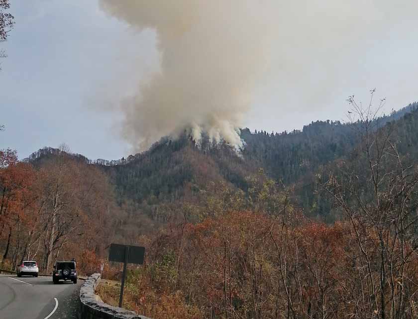
That day, five days after the fire started, was the first time that any firefighting aircraft were used on the fire. That afternoon a Chinook, a Type 1 helicopter (Type 1’s are the largest helicopters used on wildfires), began dropping water on the fire. Mr. Salansky said he expected the Chinook to refill its water bucket at Fontana Lake 13 miles to the southwest, but instead, it was able to dip out of the river below the fire. It worked until it had to refuel and then the crew in an Air Attack aircraft over the fire asked if he wanted two more helicopters, and Mr. Salansky said yes. So two other Type 1 helicopters took the place of the Chinook until dark. They were unable to dip water from the river so they refilled with water at Fontana Lake, with each making approximately three drops, he said.

Sunset that day was at 5:21 p.m. which would have allowed them to work on the fire until 5:51 p.m., 30 minutes after sunset.
Mr. Salansky asked the group he was talking to last week on the highway if a hotshot crew could put in a fire line on one of the spur ridges he pointed to, saying, “I was a hotshot for four years. I’ve been to Hells Canyon, I’ve been in Southern California, and I’ve worked in places, and, you know, feasibly, you know, it’s just not there. Especially here. I’m not even thinking, at this time, you know — this is a day-by-day thing. And I’m not thinking we’re going to have an 80 mile an hour wind event and it’s going to blow this fire all to hell. I’m thinking we’ll have some wind but nothing like that.”
Air Attack asked if Mr. Salansky wanted an air tanker to drop retardant on the fire, perhaps across the top of a ridge. He considered the river down below which, he said, was the water source for Gatlinburg, and also the cost: “We’re always taught, fight fire safely, cost effectively. What is a tanker drop that will cost $20,000 or $10,000 going to buy me? At this time I’ve got a 25-acre fire.” So he turned down the fixed wing air tanker retardant drops.
An 8-person fire module arrived the evening of the 27th. Mr. Salansky took them to a location where they could overlook the fire, but there was not a lot of active flame visible. He told them that is where they would be working the next day on the 28th. He was also counting on two Type 6 BIA engines “on the other side of the mountain” being available along with the 8-person module.
He knew the wind predicted for the next day would be from the south. He said he was counting on the river on the north side to be a barrier and secondarily the highway just north of the river. And, the fact that the fire was over five miles from Gatlinburg.
On November 28 (day #6) the first employees from the Park to see the fire were a maintenance crew at 7 a.m., who reported it, saying the fire was near the picnic area below the highway. A briefing with the 8-person fire module was scheduled for 8 a.m., but Mr. Salansky asked them to instead go the picnic area check it out. When they arrived, they confirmed the location and began protecting the structures at the site. Soon thereafter a 50-acre spot fire was seen that had become established north of the highway, about a mile and a half from the main fire.
He said when the spot fire was discovered the winds were blowing at about 30 mph, and, “the winds were not forecast to be here until that evening, like at 4 o’clock that afternoon. But they kind of came in early.”
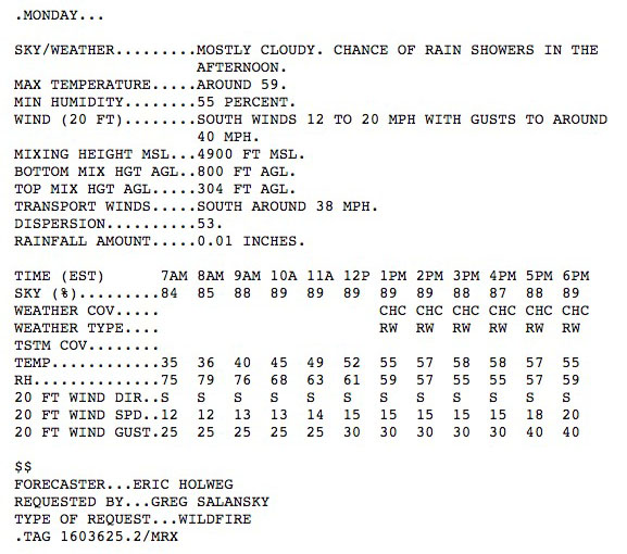
In fact, however, the spot weather forecast (above) issued at 7 a.m. November 27 predicted winds of 12 mph gusting to 25 for 7 a.m. on November 28, increasing to 15 mph and gusting at 30 by noon, and 20 mph gusting to 40 at 6 p.m. It also predicted a chance of rain showers in the afternoon. Mr. Salansky had submitted the request for that forecast, and included the comment, “Concerned about ridgetop winds with the coming front. Thanks!”
Mr. Salansky said after he saw the expansion of the fire the morning of the 28th he requested four hotshot crews, but, he said, “they just laughed at me. They’re like, there are no hotshot crews around, you know. So I said, ‘What can you give me?’ They said ‘we’re going to give you two Type 2 crews and two Type 2 Initial Attack crews but they are going to be two days out’. I’m like, ‘Order them. Give me what you’ve got’.
He explained to the group that there were other fires in the southeast and there was a shortage of firefighting resources. Also, he said, he ordered air resources that morning at 7:30. When Air Attack got over the fire they said due to the visibility there was no way that helicopters could work the fire, so his request was denied and Air Attack returned to Chattanooga.
The fact that the 50-acre spot fire was about 1.5 miles from the main fire told him “We’ve got some crazy erratic stuff going on.” The fire was spotting from ridge top to ridge top. At about 9:30 or 10 a.m. he called Gatlinburg Fire Department to give them an update on the fire. When at 11:30 a.m. another spot fire was reported near the Twin Creeks Science and Education Center (which is also the location of the fire management office) about four miles north of the main fire, about 1.5 miles from Gatlinburg, he moved the engines and the 8-person module around to that end of the fire where they went into structure protection mode. He began calling some of the local agencies that had wildland fire units, but most of them had at least a two to three hour response time. He also requested a Type 3 Incident Management Team that had an ETA of 6:30 p.m.
“All this happened in 12 hours. When somebody compares one fire to another”, Mr. Salansky said, “and how people are able to make contact with individuals and incorporate evacuation procedures and all this, sure, I could do that here if I had a 30-day window. When we have a 12-hour window you’re reacting to doing the best that you can at the time. Again, I don’t have the forethought of what all you guys have experienced over the last six months. I’m living this hour-by-hour as it unfolds. I don’t have a crystal ball saying this is what’s going to happen in three hours. ”
“People can say things. People have said things. They blame me for this. You know, if it makes them feel better, then let them do it. This is not my first fire I’ve ever been on, I’ve got some experience. I’ve been all over the country. I’ve fought fire in a lot of places.”
Shortly after Mr. Salansky began meeting with the group on the side of the highway last week he said at least twice, “I am aggressive”, in describing his philosophy for suppressing wildfires.
Rob Klein, the Fire Ecologist for Great Smoky Mountains National Park, said one thing that made the repair of damage from fire suppression activities easier was that “no containment lines were built”.
Mr. Salansky said that about 1 p.m. on the 28th he met with the fire chiefs of Gatlinburg and Pigeon Forge. “I kind of tell them what’s going on, what the potential is. I kind of recommended evacuations of my park and the vicinity.”
At about 6:04 p.m. Mr. Salansky first heard that the fire had moved in to Gatlinburg.
Mr. Salansky told the group last week about a meeting that occurred in the Gatlinburg area before the fire. “A month before all this happened, the National Wildland Coordinating Group was actually here, the Risk Management group and their Heavy Equipment group met here……. I kind of talked and we talked about the urban interface and they were like, you know, ‘What’s your evacuation process here?’ You know, I’ve seen this town and it’s bumper to bumper, I said, you know, ‘Who knows how you get people out of here.’ You can get police in here, you can, you know, get folks evacuated but there’s only two ways out of here.”


