


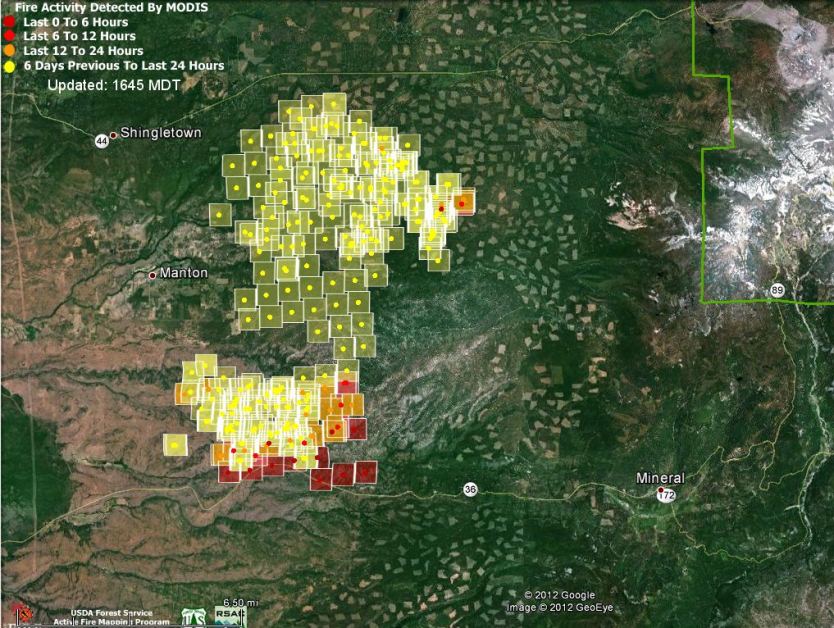
(Updated at 6:48 p.m PT, August 21, 2012)
The Ponderosa Fire, 22 miles northeast of Red Bluff, California, has grown to 21,506 acres as of Tuesday afternoon. At 6:15 p.m today CAL FIRE increased the number of structures reported as destroyed to 50, which is 43 more than they reported this morning and yesterday. Another 200 structures remain threatened. The fire is burning in a mix of grass, brush, and heavy timber and is being called 40 percent contained.
The above map shows that as of 2:15 p.m. PT today most of the heat detected by a satellite was on the south side of the fire near Highway 36. Keep in mind that the locations depicted were identified from hundreds of miles above the earth, so there can be errors by up to a mile or so.
The fire continues to burn to the east and south in the Battle Creek Drainage.
The areas that are evacuated were confirmed by CAL FIRE for the following areas in Manton, Shingletown & Viola:
- Forward Rd at Graham to the C Line
- Forward Mill Rd from Rock Creek Rd to Forward Camp Rd
- Rock Creek Rd from Manton Rd to Long Hay Flat Rd
- All of Long Hay Flat Rd and Woodcutter Way
- Southside of Highway 44 from Viola to Brush Oak
- Northside of Hwy 44 from Viola to Alward
- Hazen Rd area and South Power House Rd south of Manton
- Hwy 44 at Brush Oak east to and including Viola, Plateau Pines, Starlight Pines and Lake McCumber area
- South side of Hwy 44 from Viola to Brush Oak and on the north side of Hwy 44 from Viola to Alward
Evacuation warnings have been issued for Hwy 36 from Ponderosa Sky Ranch to Lassen Lodge communities.
Resources assigned to the fire include 2,133 personnel, 278 engines, 38 hand crews, 11 helicopters, and 53 dozers
“TurtleSloth” uploaded this video yesterday showing of one of the DC-10 very large air tankers dropping near Highway 36 on the Ponderosa fire.







