


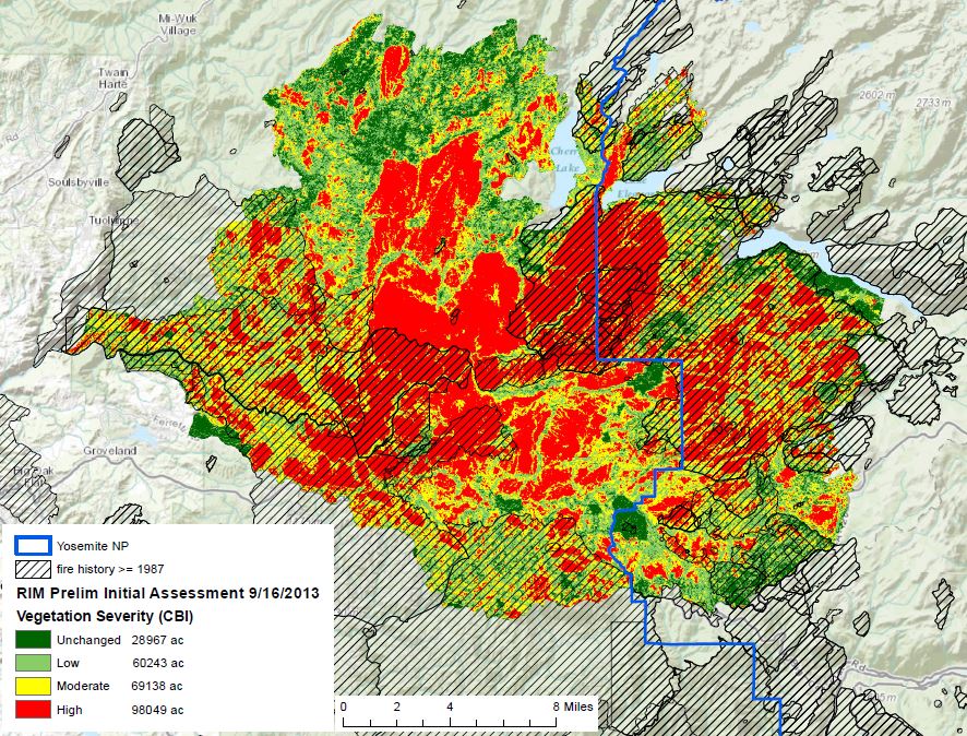
A U.S. Forest Service wildland fire ecologist that the Associated Press quoted as describing the area burned in the 250,000-acre Rim Fire in and near Yosemite National Park as “nuked” stirred up some controversy with his quoted remarks. It is difficult to use a subjective one-word description to sum up the varied fire effects on a huge fire that burned for weeks under an assortment of weather, vegetation, and topography conditions.
Most of the early assessments of burn severity on a large fire are derived from multiple sensors on satellites that are orbiting hundreds of miles above the earth. Using data from individual sensors, or combining information from multiple sensors, scientists can compare recent data with historical records to produce maps highlighting their area of interest. Two of the most common burn severity maps you will see are vegetation and soil severity.
The Burned Area Emergency Response (BAER) team assigned to the Rim Fire has publicized their version, soil burn severity maps which specifically focus on severity to soils and watersheds. The primary objective of the BAER team is to identify imminent post-wildfire threats to human life, safety, property, and critical natural or cultural resources and to take immediate actions to implement emergency stabilization measures before the first major storms. Their map of September 13 shows approximately 56% of the fire is either unburned or received a low-severity burn, 37% sustained a burn of a moderate severity, and approximately 7% burned at high severity.
The September 17, 2013 Rapid Assessment of Vegetation Condition after Wildfire (RAVG) map produced by the USFS’ Remote Sensing Applications Center (RSAC) analyzed vegetation severity produced by a change detection process using two Landsat Thematic Mapper images captured before and after the fire. They came up with very different numbers: 35% unchanged or low-severity, 27% moderate severity, and 38% high severity.
The maps from the two organizations are below. Larger versions can be seen HERE and HERE. Also included in the gallery are photos showing two areas burned in the fire, and a photo taken two hours after the fire started.







