This is an animation developed by Janice Coen, Ph.D., a Project Scientist at the National Center for Atmospheric Research in Boulder, Colorado. It simulates through a coupled weather-wildland fire environment model the spread of the Yarnell Hill Fire and the wind direction and speed. The arrows indicate the wind direction; the length of the arrows vary with the wind speed. On June 30, 2013 19 members of the Granite Mountain Hotshots were overrun by the fire when the winds from a thunderstorm cell north of the fire changed the direction of spread of the fire by about 90 degrees, surprising the firefighters on the south side of the fire, resulting in their entrapment.
See if you can tell when conditions worsened for the Hotshots.
Dr. Coen’s description of the simulation:
It begins at 2 am on 6/30/13. The fire is initialized in the model using the ~3 am VIIRS active fire detection map. Each frame is 1 minute apart, the sequence extends until 8:15 pm on 6/30. The fatality occurred around 4:45 PM. The color bar on the right indicates the heat flux (watts per square meter) from the fire, with more intensely burning areas in bright yellow and white, and less intensely burning areas in darker reds.
In the simulation, solar heating stirs up the boundary layer circulations throughout the day. Convection occurs in outer domains (not shown) to the northeast, creating high-based convective clouds as air flows south/southeast over the Mogollon Rim. Rain falls into a very dry boundary layer, creating a broad gust front that reaches the south edge of the fire at frame 936, which is 51 minutes after the fatality, so the simulated rush through the fatality site is about an hour slow.
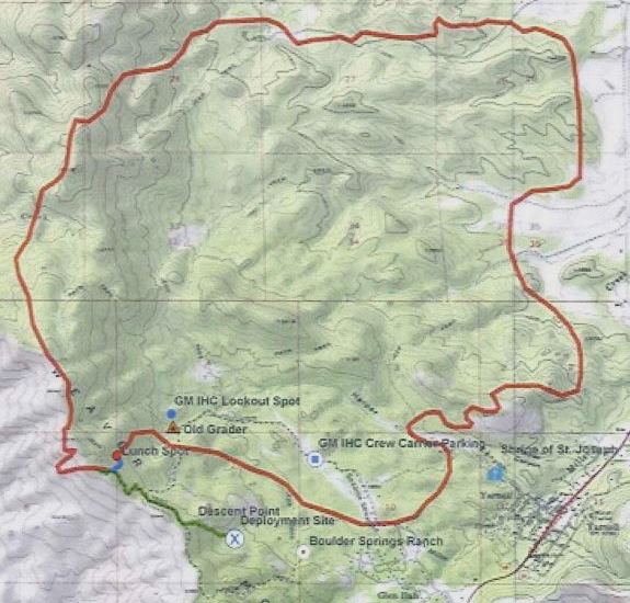
The map below shows the approximate location of the fire at 4:30 p.m. on June 30, 2013, about 15 minutes before the Hotshots were entrapped at the deployment site (X) on the south side.