
The Carr Fire has burned over 186,000 acres west and northwest of Redding, California
Continue readingVideo of MAFFS C-130 dropping on Carr Fire

The California Air National Guard shot this video of one of their Modular Airborne Fire Fighting Systems (MAFFS) C-130’s dropping retardant on the Carr Fire in Northern California July 31, 2018.
If you look closely you’ll see the lead plane produce smoke to mark the beginning of the drop.
CAL FIRE employee killed on the Carr Fire in Northern California
The California Department of Forestry and Fire Protection, CAL FIRE, announced that a heavy equipment mechanic for the agency was killed while assigned to the Carr Fire near Redding, California. Andrew Jason Brake died August 9 due to a single vehicle accident while assigned to the fire that has burned 177,000 acres west of the city.
From the Sacramento Bee:
Brake was headed north on 99, just south of Tehama Vina Road in Tehama, when the road made a slight curve to the left, California Highway Patrol officer Ken Reineman said. Brake “failed to maintain his path,” drifted off the road to the right and hit a tree. His vehicle, believed to be a pickup truck, was engulfed in flames, Reineman said. Brake died in the vehicle fire, Reineman said. The crash occurred at 12:17 a.m., he added.
Our sincere condolences go out to Mr. Brake’s family, friends, and co-workers.
Four other agency employees or contractors have died in the line of duty in the last month while working on wildfires in California:
–Don Ray Smith, contract dozer operator, of Pollock Pines, CA, on the Carr Fire July 26.
–Redding fire Inspector Jeremy Stoke, Fire Inspector for the Redding, CA Fire department, on the Carr Fire July 26.
–Brian Hughes, Captain on National Park Service Arrowhead Hotshots, Ferguson Fire, July 29.
–Braden Varney, CAL FIRE Heavy Fire Equipment Operator, July 14, Ferguson Fire.
Thanks and a tip of the hat go out to Tom and Paula.
Typos or errors, report them HERE.
California fires as seen from the Space Station
Astronaut Alexander Gerst tweeted these photos on August 3 of the wildfires in California, apparently taken from the International Space Station. He didn’t specify the date, but presumably they are very recent.
I’m not positive, but I think the photo that has multiple fires includes, from bottom to top (south to north), the Ferguson Fire at Yosemite National Park, the Mendocino Complex east of Ukiah, and the Carr Fire at Redding. The smoke farther north could be the Natchez Fire and blazes in Oregon. The other photo is most likely the Ferguson Fire.
Click on the images twice to see larger versions.
California burning. These fires are frightening to watch, even from space. Here’s a shout-out from space to all firefighters on this planet, my former colleagues. Stay safe my friends! pic.twitter.com/y7PNmR006b
— Alexander Gerst (@Astro_Alex) August 3, 2018
Excellent video of RJ85 drop on Carr Fire
Air Tanker 164
Continue readingCarr Fire: threat to Lewiston increases, Redding area improves
The fire has destroyed 1,018 residences near Redding, California
Continue readingCarr Fire still spreading, but away from Redding

Above: The red line on the map shows the perimeter of the southeast side of the Carr Fire near Igo as determined by heat sensors on an aircraft at 10:21 p.m. PDT July 28, 2019. The red shaded areas indicate intense heat. The yellow line was the perimeter about 20 hours before.
(Originally published at 5:36 a.m. PDT July 29, 2018)
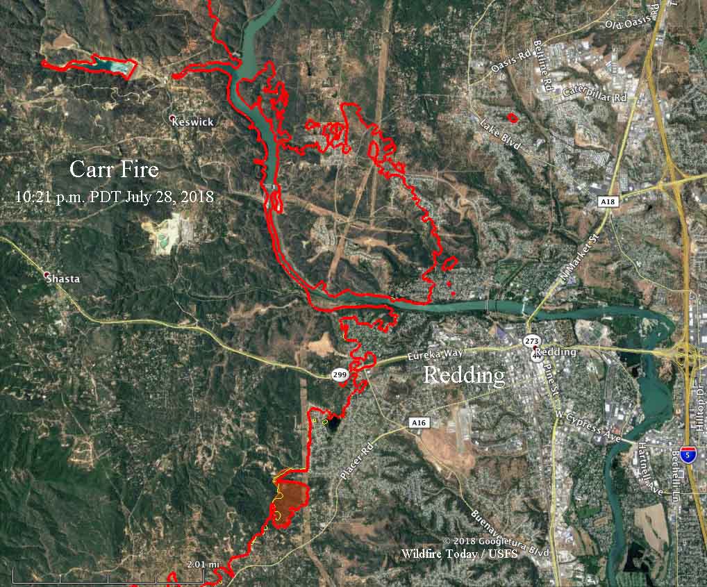
Firefighters on the Carr Fire are getting a handle on the portion of the blaze that burned into the west side of Redding, California, but it is still spreading away from the city to the south, west, and north.
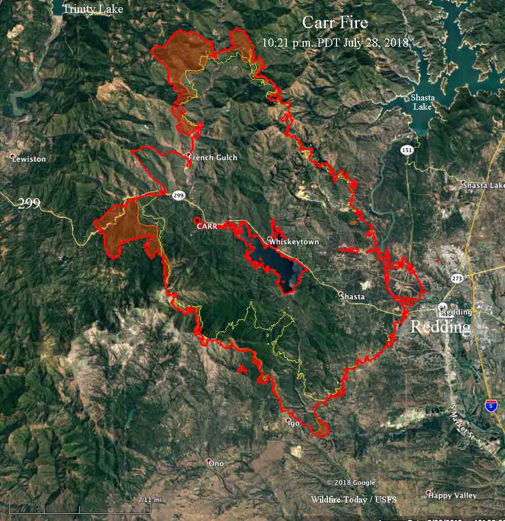
Saturday’s additional growth added another 15,000 acres to bring the total size to about 95,000 acres. Southwest of Redding it burned through the Igo area, crossing Placer Road. At 10:21 PDT Saturday it remained east of Cloverdale Road and had progressed south to Clear Creek Road. North of Igo the fire spread about a mile to the southwest on Saturday.
To see all of the articles about the Carr Fire, including the most current, click HERE.
On the northwest side, by Saturday night the fire had come to within five air miles of Lewiston and Trinity Lake and moved about three miles further west along Highway 299, burning on both sides.
The number of fatalities on the Carr Fire rose to five Saturday when officials confirmed that two young children and their great-grandmother were found dead. James Roberts, 5, and Emily Roberts, 4, were stranded with Melody Bledsoe, 70, when the fire ran through the family’s property July 26 outside Redding, California.
That same day two firefighters were also killed at approximately 6:40 pm when a dramatic increase in fire behavior occurred on the east side of the Carr Fire. Entrapped in a burn over were a call when needed contract dozer operator, Don Ray Smith, 81, of Pollock Pines and Redding fire Inspector Jeremy Stoke who had been with the Fire Department since 2004.
CAL FIRE reports that 536 structures have burned, but has not broken the number down by residences and outbuildings.
Resources assigned to the fire include 334 fire engines, 59 hand crews, 17 helicopters, 68 dozers, 65 water tenders, for a total of 3,388 personnel.
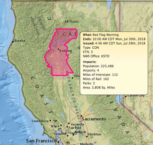
The area is under a Red Flag Warning again Sunday. The National Weather Service warns that strong winds up to 30 mph are possible in canyons in the late afternoon and overnight, but the forecast for the southeast part of the fire indicates the winds generally will be variable at 3 to 7 mph. Humidity in some areas could reach into the single digits while the temperature will be over 100 degrees. This hot, dry, trend will most likely last into mid-week.
Death count rises to five in Carr Fire
The two firefighters killed have been identified
Continue readingCarr Fire more than doubles in size near Redding, California
CAL FIRE reports 500 structures have been destroyed
Continue readingCarr Fire burns into Redding
Two firefighters have been killed while fighting the fire
Continue reading