The teenage girl on trial for starting the Cocos Fire north of San Diego was found guilty Tuesday morning. The prosecution’s case hinged on expert testimony from a CAL FIRE investigator who said a burning ember from a fire the girl admitted starting in her back yard traveled 0.44 miles to ignite the fire that eventually burned 1,995 acres and destroyed 36 homes in San Marcos, California.
Conflicting expert testimony from a retired CAL FIRE investigator who said an ember from the girl’s fire could not have traveled that far apparently was discounted by the judge, who ruled in the trial. There was no jury, because the defendant was a juvenile — 13 years old when the fire started in May, 2014.
The girl told investigators she “didn’t want to kill anybody” — only to “see what would happen” when she set the first of two fires in her backyard, according to an audio tape played in court on Monday.
The damages caused by the fire amounted to about $10 million. Sentencing is set for April 15 in juvenile court.
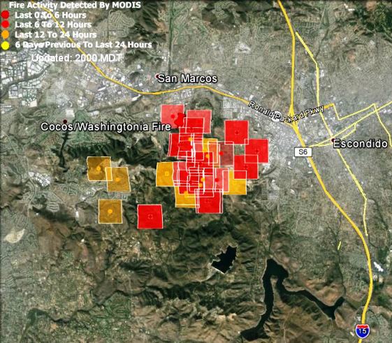
Map showing the Cocos Fire. The dark red squares represent heat detected by a satellite at 2:27 p.m. PDT, May 15, 2014. The location of the icons can be as much as a mile in error.
During the trial in which a 14 year old girl is accused of starting the Cocos Fire, wildland fire investigators gave conflicting opinions on how the fire started. The prosecution contends that when the girl, 13 at the time, started a fire near her back yard, a burning ember traveled 0.44 miles and ignited the fire that burned 1,995 acres and destroyed 36 homes in San Marcos, California, north of San Diego.
In testimony on Tuesday CAL FIRE Capt. David LaClair said he and another investigator determined that an ember from the girl’s backyard started the fire 0.44 miles away. She admitted to starting two fires that day. One was small and was extinguished.
Below is an excerpt from an article at utsandiego:
…The second backyard fire grew to 111 feet by 42 feet, according to LaClair. He said that embers from that blaze — fueled by hot and windy Santa Ana conditions — caused three spot fires. One was 14 feet to the west of the backyard fire, and it grew to 6 feet by 27 feet. Another was 245 feet west of the backyard fire, and it grew to 6 feet by 15 feet. The third became the Cocos blaze. LaClair said all three spot fires were to the west of and in line with the backyard fire.
Two other investigators testified on Friday. Below are excerpts from an article at nbcsandiego:
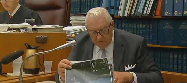
The defense’s wildfire expert, Douglas Allen, testified Friday the Washingtonia Fire did not have enough loft to launch embers more than 200 feet, let along 11 times that distance. He said strong winds like the Santa Anas blowing that day — May 13, 2014 – often bring embers to the ground.
“They have a much better chance of being lofted with less wind affecting the convection column,” said Allen, referring to the rising column of smoke and ashes created by a fire.
Upon cross-examination, Allen admitted he has written that Santa Ana winds could spread embers more than a mile away. However, he maintained that while that statement is in general true, he does not believe that happened in this case.
Deputy District Attorney Shawnalyse Ochoa then tried to put the retired fire investigator’s recent training into question. Asked when was the last time he took a wildland fire class, he said “I couldn’t remember.”
“What decade was that?” Ochoa asked.
“Was that a joke?” Allen replied laughing.
“No, sir,” the prosecutor said.
“In the last decade,” Allen testified.
Ochoa asked if he was familiar computer programs like Behave Plus or Wind Ninja – computer programs that help wildfire experts in their investigation. Allen said while familiar with them, he has not used them.
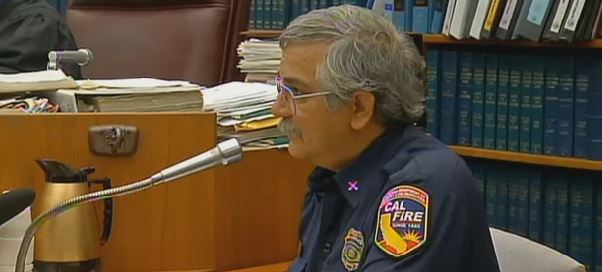
Earlier in the day, Cal Fire Behavior Analyst Tim Chavez took the stand, directly contradicting Allen. He said he has high confidence an ember from the Washintonia Fire started the Cocos blaze — what the prosecution has been arguing.
Chavez told the court a computer system estimated the wind speeds that day were around 24 miles per hour. However, he said when you stand where the Cocos Fire started, there is a narrow gap in the topography that could have pushed the winds stronger that day, sending an ember from the Washingtonia Fire to the start of the Cocos Fire.
The defense said the report on the Cocos Fire is based on a theory that doesn’t match the same conditions of the Washingtonia Fire and that theory hasn’t been proven.
The images below are screen shots from the video above, showing parts of testimony from Friday. The two people are described as investigators, but are not named. It is probable they are the two investigators named in the article, with the first being CAL FIRE Fire Behavior Analyst Tim Chavez, and the second, retired CAL FIRE investigator Doug Allen. (UPDATE at 8:10 p.m. MDT, March 22, 2015: someone who knows him confirmed that the person in the first photo is Mr. Chavez — the gentleman with the CAL FIRE shoulder patch.)
The trial began today for a girl who was 13 when she was accused of starting a fire last year in San Diego County. In May, 2014 the Cocos Fire burned 1,995 acres and destroyed 36 homes in San Marcos, California, north of San Diego.
The prosecution hinges on the theory that when the girl ignited a “branch” in her back yard, an ember from that fire traveled 0.44 miles to start the Cocos Fire west of Escondido and south of San Marcos. According to NBC 7 in San Diego the defense will have an investigator from CAL FIRE testify that the ember could not have traveled that far to start the fire.
The Cocos Fire, first called the Washingtonia Fire, was one of at least 10 fires that burned in San Diego County during the same time period in mid-May, 2014.
Map showing the Cocos Fire. The dark red squares represent heat detected by a satellite at 2:27 p.m. PDT, May 15, 2014. The location of the icons can be as much as a mile in error.
A judge has ruled that a 13-year old girl is competent to stand trial after being accused of starting the Cocos Fire. In May the blaze burned about 1,995 acres and destroyed 36 homes in San Marcos, California, north of San Diego. The judge announced his decision in a hearing where the girl pleaded not guilty to four arson-related felony charges.
The Cocos Fire was one of at least 10 fires that burned in San Diego County during the same time period in mid-May.
During the proceeding the Deputy District Attorney told San Diego Superior Court Judge Rod Shelton that the girl’s parents, who were present in the courtroom, could be ordered to pay restitution in the case. County fire officials have estimated the costs of property damage and fire suppression to be about $12 million.
Map showing the Cocos Fire. The dark red squares represent heat detected by a satellite at 2:27 p.m. PDT, May 15, 2014. The location of the icons can be as much as a mile in error.
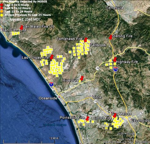
San Diego County Fires at 11:45 p.m. PDT, May 18, 2014
(Originally published at 12:03 a.m. PDT, May 18, updated at 10:12 a.m. PDT, May 18, 2014)
Camp Pendleton Fires
The most recent fire to break out at Camp Pendleton has gone by three names, Combat Fire, Talega Fire, but the latest name is San Mateo Fire. It has burned 1,500 acres in the northwest corner of the base and is listed at 55 percent contained.
The Tomahawk Fire is listed at 6,500 acres with 93 percent containment. The Las Pulgas Fire has burned 15,000 acres and is 42 percent contained.
San Diego County reports that all evacuations have been lifted at Camp Pendleton.
Cocos Fire in San Marcos
The Cocos and Highway Fires are being managed as the San Diego Complex by a CAL FIRE Incident Management Team. CAL FIRE reports the Highway Fire is 100 percent contained at 380 acres, while the Cocos Fire has blackened 1,995 acres (it keeps shrinking), is 85 percent contained, and eight structures have burned.
Other fires in San Diego County
The Poinsettia and Bernardo Fires are 100 percent contained.
Cocos and Las Pulgas Fires, showing in red the heat detected by a satellite at 4:03 a.m. PDT, May 16, 2014. The heat icons can be as much as a mile in error.
A new fire at Camp Pendleton in southern California grew rapidly after it started at 3:15 p.m. Thursday. A 5:09 a.m. update on Friday from the base said it had burned 8,000 acres and was 5 percent contained. Several areas on the base have been evacuated. Little other information about the fire is available, other than evacuation areas, since the Marines rarely allow reporters on the base when a fire is burning.
A total of 19 military helicopters are providing fire suppression support to firefighters in southern California, including eight Marine Corps CH-46 Sea Knight helicopters, seven CH-53 Sea Stallion helicopters and four UH-1Y Huey helicopters.
CAL FIRE reports that that as of early Friday morning the Cocos Fire in San Marcos has burned 3,018 acres and is 10 percent contained. See the link in the previous update for a link to a satellite map of the fire.
The weather in southern California is expected to be 10 to 20 degrees cooler than it has been, which should give firefighters a chance to make some headway on the fires.
Since the Cocos Fire started on Wednesday, 76,000 alerts have been sent to residents, via texts, emails and phone calls. The total does not translate to 76,000 people being evacuated because many residents receive the alerts by all three forms of communication.
Map showing the Cocos Fire. The dark red squares represent heat detected by a satellite at 2:27 p.m. PDT, May 15, 2014. The location of the icons can be as much as a mile in error.
The Cocos Fire, formerly known as the Washingtonia Fire, has been very active today, challenging firefighters who are trying to protect structures in remote areas surrounded by southern California chaparral. CAL Fire reports the fire has burned 1,200 acres and is 5 percent contained.
Authorities in San Diego County issued hundreds of new mandatory evacuation orders Thursday afternoon as a wildfire in the San Marcos area grew to 1,200 acres and was spreading east toward Escondido.
Escondido residents in neighborhoods north and west of West Valley Parkway between Via Rancho Parkway and Highway 78 were ordered to leave their homes as two flanks of the Cocos wildfire raged along parched hillsides overlooking the city, officials said.
Home burning in the Cocos Fire, screen capture from NBC7 at 1:54 p.m. PDT, May 15, 2014.
Nearby weather stations measured the temperature at close to 100 degrees early in the afternoon.
Various reports from County and fire officials today say that 12 or 22 military helicopters are available if needed. Some of them have been dropping on the Cocos Fire today.
****
(Originally published at 6:05 a.m. PDT, May 15, 2014)
Map of the Cocos, Poinsettia, and Bernardo Fires. The yellow and red icons represent heat detected by a satellite. The darkest red icons show heat that was detected at 3:20 a.m. PDT, May 15, 2014.
The fire in San Marcos, California that was first called Washingtonia and later changed to Cocos, is the only fire in San Diego County that was still showing large amounts of heat when the satellite passed over at 3:20 a.m. PDT Thursday. That does not mean the other fires are out, it could mean firefighters have at least temporarily slowed the spread to the point where they are not creating enough heat to be detected by the satellite hundreds of miles overhead.
Cocos Fire update- 700 acres 0% containment. Confirmed 3 homes destroyed, 1 structure damaged. Fire is still active and moving to the south.
— CAL FIRE SAN DIEGO (@CALFIRESANDIEGO) May 15, 2014
The map of the fire above shows the location of the Poinsettia, Cocos, and Bernardo Fires. The Cocos fire, according to CAL FIRE at 3:41 a.m. Thursday, has burned about 700 acres and three homes. The campus of Cal State San Marcos was evacuated Wednesday, and the City of San Marcos reported that all neighborhoods south of San Marcos Blvd, including Lake San Marcos, also evacuated Wednesday afternoon. By 10 p.m. 600 more evacuation notices were issued for the Elfin Forest, Indian Road, Crestwind Road, Wilgen Drive and De Loma Drive areas, according to county officials. Channel 8 said a total of about 21,000 residents have been evacuated. CAL FIRE reported that three homes have burned. San Diego County announced more evacuations at 4:21 a.m. on Thursday:
New evacuations in Cocos fire in San Marcos. Incl. Questhaven, Harmony Grove, parts of Elfin Forest http://t.co/7n8ptqVi1G — SanDiegoCounty (@SanDiegoCounty) May 15, 2014
(Originally published at 8:50 p.m. PDT, May 14, 2014; Updated at 7:08 p.m. PDT, May 15, 2014)
On Wednesday wildland firefighters were extremely busy in southern California’s San Diego County. We are aware of eight fires that were active Wednesday.
Tomahawk Fire, from Red Mountain at 12:24 p.m. PDT, May 14, 2014.
After being desiccated off and on for weeks by hot, dry, windy weather, the vegetation was ready to burn. East and northeast Santa Ana winds on Tuesday and Wednesday pushed the fires like freight trains across the hills and through communities. By mid-afternoon on Wednesday the winds decreased, and in some areas were replaced by a slightly cooler breeze off the ocean. This caused the spread of the fires to slow, and gave firefighters a chance, aided by an aerial armada, to move in closer and work the fires.
Washingtonia Fire near San Marcos, screen shot from Fox 5 at 5:45 p.m. May 14, 2014.
Considering the number of fires, the dense population, and how stretched thin the fire suppression forces were due to the scope of the emergencies, a surprisingly few number of homes burned. Continue reading