The National Wildfire Coordinating Group’s Operations and Training Committee wants you to take an online survey about the Wildland Fire Incident Management Field Guide, PMS 210, that replaced the Fireline Handbook in 2013.
A memo released by the National Wildfire Coordinating Group (NWCG) suggests that the new 148-page document “can be printed locally in a standard 8½” x 11”, three-ring binder format.”
When it was first introduced, the Fireline Handbook, PMS 410-1, was appropriately named, fitting easily in your hand and pocket. Over several decades it became bloated as committees kept adding everything they could think of to it until it was over an inch thick and weighed almost a pound (15 ounces). It grew to 430 pages without the optional Fire Behavior Appendix and barely fit into a pants pocket. It was last updated in 2004.
The Fireline Handbook has become less valuable as other reference guides have been introduced, including the The Incident Response Pocket Guide (IRPG) and theInteragency Standards for Fire and Fire Aviation Operations, better known as the Red Book. The newer guides had some of the same information as the Fireline Handbook.
The Wildland Fire Incident Management Field Guide still has some information that is duplicated in the Incident Response Pocket Guide (IRPG) and FEMA’s National Incident Management System Emergency Responder Field Operating Guide (ERFOG), but according to the NWCG, which published the new guide, the documents have different purposes and user groups.
Wildfire Today first wrote about the possible demise of the Fireline Handbook in March, 2011.
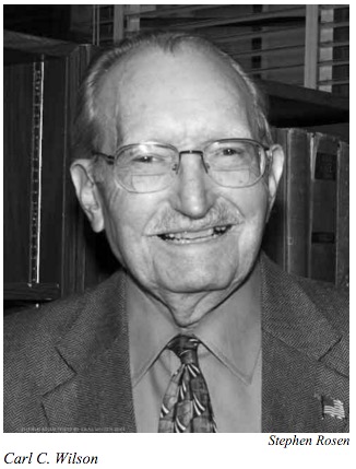
In 1976 four firefighters were entrapped on the Battlement Creek Fire, killing three near what is now Parachute, Colorado. Following the tragedy, Carl C. Wilson, who at one time was the Chief of Forest Fire Research at the U.S. Forest Service’s Pacific Southwest Forest and Range Experiment Station, published a paper titled Fatal and Near-Fatal Forest Fires: The Common Denominators.
In developing his paper, Mr. Wilson studied 67 fires that occurred during the 61-year period from 1926 to 1976 on which a total of 222 firefighters were killed from “fire-induced injuries”. He also evaluated 31 other “near-fatal” fires, searching for common themes or causes of the deaths in all of the fires. His results were considered ground-breaking. Since then his lists of Common Denominators have been republished, quoted in fatality reports, and included in many standard publications that are very familiar to firefighters.
When we listed his Common Denominators in the January 29 article we used the four that are seen in all of the recent and semi-recent publications that we looked at, including the last paper version of the Fireline Handbook (2004), the 2014 Incident Response Pocket Guide, and the report authored by Dick Mangan, Wildland Firefighter Fatalities in the United States: 1990-2006. The only revision of the Fireline Handbook since 2004 was completed in 2013 and was renamed Wildland Fire Incident Management Field Guide (PMS 210). It does not include the Common Denominators. The 2004 and 2006 editions of the Incident Response Pocket Guide also include the four-item list.
After a great deal of searching we found that there is another list of Common Denominators attributed to Mr. Wilson that has similar but different wording, and has five instead of four. The five-item list was in a 2011 paper by by Martin E. Alexander and Miguel G. Cruz and also in the 1998 version of the Fireline Handbook.
The first, the five-item list, is printed on the first page just below the heading “Common Denominators of Fatal Fires”. Here is the text just below that heading:
“Based on personal knowledge and information obtained from reports and reviewers, the following generalizations can be made about the fatal fires in Tables 1 and 2 [tables 1 &b 2 are fatal fires]:
Most of the incidents occurred on relatively small fires or isolated sectors of larger fires.
Most of the fires were innocent in appearance prior to the “flare-ups” or “blow-ups”. In some cases, the fatalities occurred in the mop-up stage.
Flare-ups occurred in deceptively light fuels.
Fires ran uphill in chimneys, gullies, or on steep slopes.
Suppression tools, such as helicopters or air tankers, can adversely modify fire behavior. (Helicopter and air tanker vortices have been known to cause flare-ups.)”
A key to that list is that it only applies to the 67 fatal fires he studied, and not the 31 that were near-fatal.
Toward the end of the paper in the “Conclusions” section, Mr. Wilson wrote:
“There are four major common denominators of fire behavior on fatal and near-fatal fires. Such fires often occur:
On relatively small fires or deceptively quiet sectors of large fires.
In relatively light fuels, such as grass, herbs, and light brush.
When there is an unexpected shift in wind direction or in wind speed.
When fire responds to topographic conditions and runs uphill.”
We’re not sure why Mr. Wilson broke down the common denominators into fatal and near-fatal fires. I don’t know that it adds value, but can, and has, produced a little confusion when two different versions of the lists are floating around.
The reincarnation of the Fireline Handbook, now saddled with the name Wildland Fire Incident Management Field Guide, is now available as an eBook for your Apple and Android devices. The January, 2014 revision is described on the Google Play store as “scanned pages”, and is designed for tablets or the “web”.
I downloaded the Android version and viewing it in a web browser on a 20-inch monitor was not a satisfying experience. It looked like a low-resolution scanned document. However on a 7-inch Nexus tablet the text was small when viewing an entire page, but it was very sharp and quite readable. Flipping from page to page was easy as pie. It would probably be even better on a larger tablet but don’t even think about trying to read it on a smart phone.
The Fireline Handbook, last revised in 2004, was officially retired in 2013 and replaced with an electronic version, a .pdf, of the Wildland Fire Incident Management Field Guide (PMS 210). The National Wildfire Coordinating Group explained last year why they created the new publication:
The document was renamed because, over time, the original purpose of the Fireline Handbook had been replaced by the Incident Response Pocket Guide. As a result, this document now serves as a guide for wildland fire managers and subsequent staff.
A memo released by the National Wildfire Coordinating Group (NWCG) suggests that the new 148-page document “can be printed locally in a standard 8½” x 11”, three-ring binder format.”
When it was first introduced, the Fireline Handbook, PMS 410-1, was appropriately named, fitting easily in your hand and pocket. Over several decades it became bloated as committees kept adding everything they could think of to it until it was over an inch thick and weighed almost a pound (15 ounces). It grew to 430 pages without the optional Fire Behavior Appendix and barely fit into a pants pocket. It was last updated in 2004.
The Fireline Handbook has become less valuable as other reference guides have been introduced, including the The Incident Response Pocket Guide (IRPG) and theInteragency Standards for Fire and Fire Aviation Operations, better known as the Red Book. The newer guides had some of the same information as the Fireline Handbook.
The Wildland Fire Incident Management Field Guide still has some information that is duplicated in the Incident Response Pocket Guide (IRPG) and FEMA’s National Incident Management System Emergency Responder Field Operating Guide (ERFOG), but according to the NWCG, which published the new guide, the documents have different purposes and user groups.
Wildfire Today first wrote about the possible demise of the Fireline Handbook in March, 2011.
On April 20 Wildfire Today covered the jury verdict following a trial that awarded $730,000 to the owners of a Montana ranch, part of which burned in the Ryan Gulch wildfire in 2000 during a period that saw numerous fires burning across the state. The heart of Fred and Joan Weaver’s case was their contention that firefighters used poor judgement in selecting and implementing an indirect strategy of backfiring, rather than constructing direct fireline on the edge of the fire. In the process, they argued, more land burned than was necessary, including 900 acres of their ranch. The jury decided that of the monetary award, $150,000 was for the loss of timber, $200,000 was for the rehabilitation of pasture land, and $350,000 was to compensate them for the mental suffering and anguish of seeing their ranch threatened by the fire.
In the 18 hours since we posted the article, seven comments have been left by our readers, including two from the Weaver’s attorney, Quentin Rhoades. Mr. Rhoades is not your typical barrister. He worked as a wildland firefighter for eight seasons between 1987 and 1994, serving on the Helena Hotshot crew and later as a smokejumper at West Yellowstone and Missoula. He told Wildfire Today that he was in the first planeload of jumpers on the South Canyon fire in Colorado in 1994, the fatal fire on which 14 wildland firefighters were entrapped and killed.
The Ryan Gulch fire was managed by a Type 1 Interagency Incident Management Team from the southeast, the “Red Team”, with Mike Melton as Incident Commander working under a delegation of authority from the state of Montana.
The list of witnesses for the State of Montana included:
George Custer, the Type 1 Operations Section Chief on the fire, who recently retired as the Incident Commander of a National Incident Management Organization (NIMO) Team. (As this is written on April 21, 2012, Mr. Custer is still listed on the NIMO web site as the IC of the Atlanta NIMO team.
Three firefighters who work for the Montana Department of Natural Resources and Conservation — two initial attack firefighters, Mark Nenke and Todd Klemann, and Jonathan Hansen, who according to Mr. Rhoades “was in charge of the Red Team for the State”.
Stephen Weaver (no relation to the Plaintiffs), the Planning Operations Section Chief for the Red Team on the fire. Mr. Weaver has been working for the U.S. Forest Service for 38 years.
Ron Smith, who was a Division Supervisor for the Red Team, presently working as a USFS District Ranger in Mississippi.
Shelly Crook, retired from the USFS, served as the State’s expert witness as a Fire Behavior Analyst
Chuck Stanich, retired from the USFS, was the State’s Type 1 Incident Commander expert. He is a former Fire Management Officer for the Lolo National Forest and Type 1 Incident Commander.
Red Team members who worked on the fire but did not testify included the Incident Commander Mike Melton, retired from the USFS; Tony Wilder, the Night Operations Section Chief; and Keith Wooster, the Fire Behavior Analysist, now retired from the USFS.
The Plaintiffs called one expert witness, Dick Mangan, who retired from the U.S. Forest Service Technology & Development Center in Missoula, Montana in 2000 with more than 30 years of wildfire experience. He is a past president of the International Association of Wildland Fire and currently works as a consultant in wildland fire, instructs fire courses, and raises black angus cattle in Montana.
Mr. Rhoades told us that local firefighting resources from the area staffed some divisions on the fire, and they employed direct tactics, not burning out or backfiring, and never used a drip torch or a fusee for igniting vegetation. He said they offered their local expertise to the Red Team but it was refused. Instead, the Red Team “planned and used all kinds of firing operations from day one”.
According to Mr. Rhoades, the firing operations were approved by the Incident Commander and were planned by the Day and Night Operations Section Chiefs, and the Planning Operations Section Chief, who consulted the fire behavior forecasts prepared by the Fire Behavior Analyst. However, no records could be found in the incident files that any backfires were ever lit or that there were any written planning or oversight documents related to backfires. While 272 pages of Unit Logs were found in the incident records, none of them were completed by Division Supervisors. George Custer, one of the Operations Section Chiefs on the fire, testified that Unit Logs were not necessary for Division Supervisors, but the 1998 Fireline Handbook uses the word “must” when talking about Division Supervisors completing Unit Logs. Members of the Red Team said the Fireline Handbook was “not authoritative”.
Mr. Rhoades got Chuck Stanich, a witness from the State, to admit under cross-examination that from studying the documentation, it was clear that no backfires were ever lit. Mr. Stanich and Mr. Mangan both held the opinion that if backfires were ever lit, they were done without adequate planning, documentation, and oversight. But locals, as well as George Custer, the Operations Section Chief who planned the backfires, testified that backfires were used on the fire. Apparently, the jury was convinced that backfires were used on the fire, but since there were no written records of planning or approval of them in the incident files, then they must have been conducted without adequate planning and oversight.
The jury also heard testimony about two near misses on the fire which were not documented or investigated. One involved two volunteer firefighters, and the other involved a Division Supervisor and two dozer operators. Regarding the second incident, Mr. Rhoades wrote in a comment on Wildfire Today April 20:
I stood on the spot, on the ridgetop, with one of those who nearly died. We could see right down to the Clark Fork from where they were about to be burned over. They would have all three died if a Type 1 helicopter had not been already operating within a mile of the blow-up. It dropped load after 2000-gallon load from the river right on top on them or they’d be dead, as they hurried their dozers down 40 and 50% slopes. Not to mention the 9,000 extra acres of land that burned.
These incidents may have helped to create in the minds of the locals serving on the jury that the Incident Management Team from the southeastern United States, where fires burn differently than in the west, was out of their element in Montana.
It may also be difficult to convince a jury pulled in off the street that setting fire to more vegetation can be a successful strategy of wildfire suppression, especially if local volunteer firefighters say they did not use that technique. There could also be an us-versus-them attitude, with rural Montana residents failing to see the benefit of the Federal Government’s fancy-dancy team from the other side of the country coming into their area and doing their own thing without adequately respecting ranchers and the expertise of local firefighters.
What can firefighters and Incident Management Teams learn from this?
First, do all the damn paperwork that’s required, especially Unit Logs. It’s not the most fun part of the job, but grow up. You can’t ignore this. Some teams attach a blank Unit Log form to every Incident Action Plan.
Document all major decisions, especially those that could be controversial.
*Conduct outreach with locals, have town meetings, personally interface with landowners that are directly affected by the fire, use web sites and social media, including but not limited to InciWeb and Twitter, updating them many times a day. Provide updated maps once or twice a day.
Talk with local firefighters. Become informed about local weather and fuel conditions, as well as local firefighting tactics that have been successful in the past.
Ensure that the final incident paperwork package is complete.
Follow-up on near misses. Document and investigate as necessary and required.
If the Fireline Handbook, Red Book, or other manual says something must be done, don’t interpret that as a tip, hint, or suggestion.
*Over the last few years, especially in 2011 in the Southwest, I observed that some Type 1 IMTeams really suck at stakeholder outreach and keeping the public informed. During the fatal Lower North Fork fire near Denver in March the Jefferson County Sheriff’s office did a wonderful job before the Type 1 IMTeam assumed command of the fire. They updated their web site numerous times a day, briefed the media on a regular schedule, held briefings for local residents after the media briefings, and used Twitter, providing a great deal of information to their community of very concerned citizens. They did not use InciWeb, but plenty of information was available on their own web site. Organized IMTeams could learn a lot about public information from the Jefferson County Sheriff’s office.
UPDATE April 23, 2012:
The Ryan Gulch fire was 30 miles west of Missoula and 8 miles east of Drummond, Montana. The trial was held in Philipsburg, MT (map), a town with a population of 930 in 2009.
The National Wildfire Coordinating Group is considering doing away with the Fireline Handbook (FH), or at least that is one of the options mentioned in an email sent out by the NWCG’s Operations and Workforce Development Committee. Here is an excerpt:
The Operations & Workforce Development Committee (OWDC) is in the process of revising the Fireline Handbook, and is seeking your input.
Over time, the purpose of the Fireline Handbook has changed a great deal. Since the advent of the Incident Response Pocket Guide (IRPG), the Fireline Handbook’s use has changed dramatically. It is no longer the fireline reference for firefighters and has become more of a standards guide for incident overhead.
As a result, the OWDC is seeking wide input on the future of the Fireline Handbook. We are considering whether or not it needs to continue, what its future purpose should be, and a change in the name of the document.
The FH is not the easiest thing to carry around, weighing in at almost a pound (15 ounces) and it barely fits into a pants pocket. It has 430 pages, without the optional Fire Behavior Appendix. The number of pages could be reduced by 20-40% if it were reformatted with smaller margins, and without all the “white space” and blank lines between listed items. Most of the publication is devoted to checklists and how-to guides for overhead personnel and is not very useful for ground-pounders or most Operations section personnel.
The Incident Response Pocket Guide (IRPG) (download a .pdf of the 2010 version) has become far more valuable to Operations personnel on the fireline than the FH. It has most if not all of the safety and operations check lists, plus many items that are not included in the FH. And it is updated annually. The IRPG is more useful for Operations personnel out on the ground or the fireline. It is designed for a shirt pocket, has 110 pages, and only weighs 2.5 ounces.
Both publications are useful, but my suggestion would be to keep the IRPG the way it is, but modify the FH to remove the duplication which is also in the IRPG. And reformat it as described above, with both changes reducing the number of pages by about half.
The name should be changed to remove the association with the fireline, since it is primarily, and will be even more so, for overhead personnel, most of whom would not be out in the field but would be in an Incident Command Post or other administrative facility. One of the suggestions in the online survey for a new name is “Incident Management Guide”, which would make it more of an all-hazard publication.
What do you think? Keep the Fireline Handbook the way it is, modify it, or get rid of it?
John Covele, President of Pocket Mobility. Photo: pocketmobility.com
More than 40,000,000 iPhones and iTouches have been sold and some of them are in the hands of firefighters. Fire behavior software that was originally written for computers running Windows, and Personal Digital Assistants on the Palm operating system, became available on June 1 for iPhones and iPod iTouches.
Wildland Toolkit
One of the programs is called Wildland Toolkit, and while it does not claim to run the BehavePlus program, the developer says its calculations “are similar to what is done with the BEHAVE software, but you will find the user interface much easier to use”.
The program was written by John Covele, who is a volunteer firefighter and EMT-B with the Boulder Rural Fire Protection District in Colorado. In his day job he is a software engineer and the owner of Peakview Software, formerly Pocket Mobility.
Screen shot from Wildland Toolkit (from peakviewsoftware.com)
For the November, 2001 issue of Wildfire magazine I reviewed Fire Away which was Mr. Covele’s very early version of the program and was written for the Palm and Pocket PC operating systems. The software later evolved into Wildland Fire Toolkit for Windows based computers and for the Palm and Windows Mobile operating systems, and finally into the version we have today for the iPhone, Wildland Toolkit.
The BehavePlus and Wildland Toolkit programs both require wildland fire experience and formal wildland fire behavior training in order to input and interpret the data. After the user enters fuel, weather and topography information, it will generate:
Relative Humidity and Dew Point
Fine Dead Fuel Moisture
Probability of Ignition
Flame Length
Rate of Spread
Scorch Height
Direction of Maximum Spread
Effective Wind Speed
I have not seen a copy of the program, but judging from the web site, the program will not calculate some outputs that the Behave program will, including Size, Spot, Contain, and Mortality. In an email, Mr. Covele said Wildland Toolkit is…
…an evolution of the original FireAway [that] has been shipping for many years, with lots of features. The new iPhone version has fewer features since we have to port the software and rewrite it. Eventually, of course, it will have many of the same features and hopefully more new ones.
Based on the heritage of Wildland Toolkit for other platforms, you can expect more features to be added from the Fireline Handbook and Incident Response Pocket Guide, making this more of a general wildland fire reference and not just a calculator.
He said the initial updates will be free through iTunes.
911 Toolkit
Mr. Covele has another program for firefighters called 911 Toolkit. This program’s ancestor was the Fire Hose program which I reviewed in 2001. The new program, also available for the iPhone and iTouch, can calculate:
Flow Rate for solid stream and fog nozzles
Friction Loss for several hose types
Pump Pressure for desired nozzle pressure
Water volume in hoses
Dry weight of hoses
Total weight of hoses
Hydrant testing: observed and available flow rate
How much?
The Wildland Toolkit and 911 Toolkit are two of the 50,000 applications in the iPhone app store and sell for $9.99 and $4.99 respectively. The first versions, Fire Away and Fire Hose sold for $59.00 and $19 respectively, in 2001.
New iPhone available June 19
Apple today announced a new version of the iPhone, the iPhone 3GS, which will be available on June 19 for $199 to $699. Some of the new features include an electronic compass, a 3 MP camera with autofocus, a 30 fps video camera, and a beefier battery.
The existing 8GB iPhone 3G is still available but at a new reduced price, and of course they still only work on the AT&T network.
UPDATE: November 25, 2009
I talked with John Covele, of www.peakviewsoftware.com and asked him if he was going to develop a version for the Android operating system, and he said he has no plans to do so at the moment, but maybe if he heard from enough of us he would. You can send him an email from their “About” page.
President Bush is expected to fly in to the Redding, California airport around 2 p.m. today. Then he and the Governor will cruise around in a helicopter looking at the fires. This will be the first time a sitting president has visited Redding since John F. Kennedy was there in 1963 for the dedication of the Whiskeytown Dam.
Bush will also attend a private Republican fund raiser in Napa.
UPDATE @ 2026 PT, July 17
A reporter for the Redding Record Searchlight, Ryan Sabalow, was at the Redding airport for the President’s visit and was using his Blackberry to send live updates to the newspaper. Here is his description of when the President stopped by to see the jumpers:
Prez Bush just walked into smokejumper room. Walked up to John Casey, a 38-year-old jumper with almost 200 jumps in his career.
“I couldn’t handle it,” he said to Casey.
Bush asked him how many jumps. His eyes got wide at the number — 200.
“I appreciate your service,” Bush said.
Bush went around the room shaking hands and greeting the smokejumpers, who appeared busy sewing and prepping their chutes.
One was so fixed on his work that he apparently missed the president’s approach from behind.
“I don’t want to interrupt,” Bush said, drawing laughter from reporters and firefighters alike.
Gov followed being giving kudos to the firefighters.
“Good to see you,” he said to Casey. “Keep up the good work.”
UPDATE @ 1413 PT, July 17:
Here is part of a transcript from a “press gaggle” that occurred today at 10:55 p.m. PT on Air Force One on the way to Redding, California. Mr. Stanzel is a spokesperson for the President. Under Secretary of Agriculture Mark Rey also participated in the gaggle.
Mr. STANZEL: At 2:30 p.m. today, when we arrive in California, the President will participate in a briefing on the California wildfires. That will be at — in Redding, California. We’ll have pool at the top, and he’ll receive a briefing on the response efforts from federal, state and local officials.
And as you — I’ll let the two experts here talk a little bit about the fires themselves, but I would just note that on June 28th, the President signed an emergency declaration for the state of California; that is providing federal funding and support. And we have lots of information about the fires, and these are the single-largest — this is the single-largest fire event in the history of California with over 1,300 square miles burned since June 21st.
After the President participates in that briefing on the California wildfires, he is going to participate in an aerial tour of the area, of Redding, and he will be joined in that by Governor Schwarzenegger. Administrator Paulison will also be there for an aerial tour of the Shasta-Trinity National Forest. And following the aerial tour, the — Governor Schwarzenegger and the President will deliver brief remarks.
[…]
Q And square miles burned?
UNDER SECRETARY REY: I was afraid you were going to ask square miles burned — it’s about 900,000 acres burned. I’d have to get you the — it’s 66 acres per square mile, so — (laughter) — if you want the divide that number by 66 —
Q Can you give us an idea of what he’ll see in the aerial tour?
UNDER SECRETARY REY: What he’ll see in the aerial tour is areas of the Shasta-Trinity National Forest that have burned, as well as areas that have been thinned to reduce flammable materials. He’ll also see a couple of thinning projects that did result in our ability to put out a fire more easily.
[…]
UNDER SECRETARY REY: Let me correct a number I gave you. It’s 640 acres per square mile. So I’ve got to remember that. I have a hard time with the metric system and all that sort of stuff. I don’t trust it.
The President will be briefed at the U.S. Forest Service smoke jumper base before he departs for his flightseeing tour. He will meet with Cal Fire Chief Ruben Garijalva, Randy Moore, U.S. Forest Service Regional Forester, Gen. William Wade from the National Guard, and Henry Renteria, director of the California Office of Emergency Services. After his briefing he will visit the smokejumper loft and say hello to the jumpers working on their chutes before he departs on a helicopter for a tour of the Shasta-Trinity National Forest.
Basin fire, Big Sur area
The satellites have detected quite a bit of heat north and south of the White Oaks area that is outside of yesterday’s fire perimeter, apparently the result of quite a bit of firing from the dozer lines. The update from the fire late yesterday had this information:
Today’s burnout operations went well on Chew’s Ridge. Burning conditions were optimal and a combination of tools, including the helitorch, was used to meet today’s objectives. It is expected that operations will extend east along the containment line to Carmel Valley Road tonight. Burnout operations in this area will continue through the coming days as weather conditions permit.
At the south end of the fire, along Carrizo Trail, the Cobra helicopter that is outfitted with an infrared camera found no remaining hotspots near the containment line.
Burnout operations also continued east of Devil’s Peak on the north edge of the fire, and will continue in the coming days as conditions permit.
The King City Incident Command Post and Carmel Valley Spike Camp have been combined and relocated to Carmel Valley Road near Tassajara Road.
At a public meeting Tuesday night a Forest Service spokesman used technical jargon to explain the slopover in the White Oaks area:
“Two nights ago, we had a little oops,” Buck Silva of the U.S. Forest Service told a group of more than 100 residents at a community meeting late Tuesday at Tularcitos Elementary School in Carmel Valley.
“We’re making progress,” he said. “We just had this little pooch-out that delayed us a couple of days.”
I can’t find “a little oops” or “pooch-out” in the glossary in the Fireline Handbook.
The fire is 122,980 acres and is 61% contained. The map below is of the White Oaks area.
This map shows how much heat (in red) was detected by the satellites outside the last perimeter (in yellow) uploaded by the incident management team. I am going to assume that all of the heat shown shown outside the perimeter, including that on the northeast side in the White Oaks area, was created by the burnouts from the dozer lines.
Cold Springs fire, Mt. Adams, Washington
The spread of the Cold Springs fire on the lower slopes of Mt. Adams in southwest Washington has slowed. After quickly burning over 7,000 acres, it is now about 7,900 acres. Yesterday morning it was 5% contained, but that percentage has increased since then.


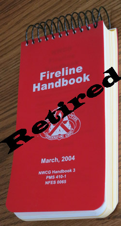 The Fireline Handbook has been retired and replaced with an electronic file, a .pdf, called Wildland Fire Incident Management Field Guide (PMS 210).