The United States Forest Service announced a new wildfire risk reduction agreement with Idaho officials on Friday that will, in part, double the state’s current timber production.
The USFS and Idaho committed to increasing an annual sustainable timber sale volume of up to 100 million board feet within five years, which would be double the state’s current output, according to a press release from the Service. Officials said the agreement supports President Donald Trump’s Expansion of Timber Production Executive Order to increase timber harvests on national forests by 25% by 2028.
“For too long, federal red tape and hands-off policies left our forests overgrown and our communities at risk,” U.S. Secretary of Agriculture Brooke Rollins said in the press release. “By doubling timber production through Good Neighbor Authority and speeding up active management, we’re protecting Idaho families, supporting rural jobs, and making our forests stronger for generations to come.”
Idaho Governor Brad Little previously signed his own “Make Forests Healthy Again Act” executive order in April to increase collaboration between the state and federal government for the purpose of wildfire reduction and general forest management.
The governor held a press conference announcing the new agreement on Friday, calling the agreement essential to meeting the “forest health crisis” on federally owned land.
“Years of inadequate management have led to millions of acres of forest service lands becoming high-risk for insects, disease, and wildfires,” Little said at the press conference. “Idahoans are tired of megafires, endless smoke, and soaring suppression costs. We have a rare opportunity to shift the trajectory.”
The increased logging may face legal hurdles. Multiple conservation groups in nearby Montana recently sued the USFS over a logging road project on their state’s border with Idaho, according to BYU-Idaho Radio. The Beaverhead-Deer Lodge National Forest recently signed off on a new project to burn trees and put new logging roads in the Continental Divide, which the groups say will inflict unnecessary danger to local wildlife, including endangered grizzly bears and sage grouse.
The man suspected of shooting and killing two firefighters in Idaho has been identified by local authorities.
Kootenai County Sheriff Bob Norris, at a press conference Monday afternoon, said investigators identified the deceased suspect as Wess Roley. Law enforcement found Roley’s body at the scene of the fatal Idaho wildfire shooting, along with a high-powered rifle and a flint starter, which investigators believe he used to start the wildfire to lure firefighters into an ambush, according to Norris. Investigators did not share how they believe Roley died.
Norris said Roley had no criminal history and local law enforcement had five interactions with him, but they were minor. Roley also has no link to any international or domestic terrorist organization. Investigators said they discovered that Roley, at one time, wanted to be a firefighter, but there is still no clear indication of motive.
Investigators believe Roley shot and killed himself at the scene of the crime.
“We’re still processing the scene, and it’s going to take a few days to do that, especially with the current fire that’s there,” Norris said.
The wildfire that investigators believe was started by Roley, named the Nettleton Gulch Fire, remains at 26 acres. Norris said firefighters believe they’ll have the fire contained by Monday night.
WildfireToday and the International Association of Wildland Fire share our condolences with the families of the victims.
Hours after firefighters in Idaho broadcast they were being shot at, two of the firefighters are dead and the lone gunman’s body has been recovered, Kootenai County Sheriff Bob Norris said at a press conference Sunday night.
A firefighter from the Coeur D’Alene Fire Department and a firefighter from the Kootenai County Fire & Rescue were those who died. A third firefighter was shot and was in critical condition before being transported to a local hospital. Norris said that the firefighter’s condition is now stable after undergoing surgery.
Firefighters responded to the wildfire near the town of Coeur D’Alene at around 1:21 p.m. on Sunday, according to Norris. Calls for shots fired were sent out at around 2 p.m.
Law enforcement officers who responded to the scene reportedly exchanged gunfire with the suspect between 2 p.m. and 7:40 p.m. During that time, officers used what they called a “cell phone activation” to pinpoint the shooter’s location.
The activation found a phone that had been sitting in the same spot for hours. That’s where law enforcement would eventually recover the suspect’s body, along with a high-powered rifle. Investigators have not shared how they believe the suspect died.
“Keep in mind, we had a fire that was rapidly approaching the body, so we had to scoop up that body and transport it to another location…we believe that is the only shooter that was on that mountain at that time,” Norris said.
Investigators believe the suspect, who has since been identified as Wess Roley, started the fire to lure firefighters to the location for an ambush. Norris said Roley had no criminal history and local law enforcement had five interactions with him, but they were minor.
Norris said investigators would not release the identities of the victims, as the investigation is still in its very early stages.
The wildfire, named the Nettleton Gulch Fire, has burned 26 acres and is 0% contained as of Monday morning, according to the Idaho Department of Lands.
WildfireToday and the International Association of Wildland Fire share our condolences with the families of the victims.
When Ed Pommerening died last Christmas Eve in Kellogg, Idaho he left a forestry legacy that is unmatched in Idaho history. I grew up in Kellogg and knew Ed mostly by reputation. We last talked by phone in 1996. I was in the middle manuscripts for an Evergreen edition featuring forests and forestry in Idaho and I wanted to include a short story about the miraculous rebirth of forests on the barren hills of my youth.
Ed is the reason Idaho’s Silver Valley between Smelterville and Big Creek is covered with countless thousands of conifers, many of them 50 feet tall. It is a stunning tribute to the dogged determination of a young man who once told me that the Kellogg he saw for the first time in 1972 reminded him of the godawful agent orange devastation he’d seen while serving with the 101st Airborne Rangers in South Vietnam.
That young man was Ed Pommerening. He was coming to Kellogg then to begin work as the Bunker Hill Company’s first forester. “Uncle Bunker” was by far Idaho’s largest industrial employer, the Union Pacific Railroad’s largest customer by tonnage, and the largest power consumer in the entire Washington Water Power system. At one time, Bunker Hill was the largest mining and smelting company in North America. It supplied most the lead we threw at the Germans and Japanese during the Second World War.
I worked my way through college in company stopes a mile beneath the streets of Kellogg. It was dangerous as hell — but great fun. I have no idea what convinced Ed that he could turn the Silver Valley’s barren hills green again — or how he convinced the company to invest in the crazy idea that he could grow countless thousands of seedlings 3,000 feet down in the mine, but in August 1975 company carpenters built Ed’s first 40-foot long underground greenhouse. One of my late father’s plumbing crews ran the water lines.
The scale of Ed’s thinking was breathtaking but the idea was not new. Many miners grew vegetables in pots in pitch black drifts with only the illumination of a single lightbulb. The air temperature was a constant 72 degrees, so all you had to add was some soil, water from a nearby drill line, a little light, and voila! It certainly helped that Ed had earned two forestry degrees from the University of Idaho. His connections would prove invaluable after his first seedlings died soon after they were transplanted on treeless hills by high school kids and civic groups.
The same thing had happened to seedlings my Cub Scout pack planted in Vergobbi Gulch in the 1950s. We never knew why, but soil scientists at the University of Idaho figured out that sulfur dioxide gas released from stacks at the Bunker smelter had polluted the soil. Acid was killing the seedlings. The solution: plant them deeper and add a dash of neutralizing potash for good measure. The beautiful result graces both sides of Interstate 90 between Smelterville and Big Creek: Ponderosa, Scotch and Austrian pine, Douglas-fir, western larch, western white pine, blue spruce, willow, and poplar.
The homesteader’s apple orchard behind our home on Mission Avenue has given way to a sea of green that turns to gold in the fall. Words seem inadequate.
A very good case can be made for the fact that the Silver Mountain Resort and Ski Area and its legendary gondola are prospering today because of Ed Pommerening’s modesty and quiet determination. Small wonder that his forestry consulting business, Riverview Timber Services, thrived for decades.
The Kellogg where I grew up is long gone: the smelter whistles that announced shift changes, the friends I made underground, Al Laramie at the piano on Friday nights at the old Sunshine Inn, and the vibrancy of Kellogg’s booming economy. We thought Bunker would go on forever. For better or worse, it didn’t. The end came in 1981. Labor strife and unattainable federal air and water quality standards were the main reasons. But Ed’s vision provided the catalyst for Kellogg’s rebirth.
The power of forestry turned the barren hills of my youth green again and my hometown has a future. There is a bronze statue of a miner at the corner of Main and McKinley Avenue in uptown Kellogg. There needs to be one of Ed standing beside him.
WATCH THE VIDEO: The Reforestation of Silver Valley is a fascinating story told by Ed Pommerening and others about an industry that took the initiative to solve a major environmental problem in northern Idaho. The video was funded by the Kootenai-Shoshone County Farm Bureau and Idaho Farm Bureau and was produced by Matthew Bane. Watch it [HERE].
Smokejumpers who survived a 1961 wildfire on Higgins Ridge in Idaho will recount their harrowing experience in a film on Monday on Montana PBS. The Daily Inter Lake in Kalispell reported that “Higgins Ridge,” named for the location of the fire in Idaho’s Selway Bitterroot Wilderness, will air January 30 at 8 p.m. Mountain Time.
The U.S. Forest Service sent 20 smokejumpers to what looked like a routine fire from the air, but an afternoon cold front blew the blaze to an inferno on the Nez Perce National Forest. The jumpers, 8 from Grangeville and 12 out of Missoula — many of them rookies — shifted from fighting the fire to fighting for their lives. They instinctively wanted to run to safety, but they remembered the fate of 13 firefighters who had tried to outrun a fire in Montana’s Mann Gulch 12 years before.
With that tragedy in mind, they decided to hold up. As the wind increased to 50 mph the supervisors of the two squads, Dave Perry and Fred “Fritz” Wolfrum, instructed the firefighters to remain calm and to clear an area for themselves in the black.
In the film, 12 of the 20 men who jumped the fire on August 4, 1961, share the story of how the fire surrounded them, showered them with embers, and forced them to shelter in place. After about three hours, helicopter pilot Rod Snider managed to land his Bell 47B-3 on Higgins Ridge, about 83 miles southwest of Missoula, despite heavy smoke and wind, and he shuttled the jumpers to safety. Snider, then a pilot with Johnson Flying Service who is now 92 years old, is featured in the documentary along with many of his original photos from 1961.
A Bell 47G helicopter, USFS photo.
“This is a story that, for 60 years, never was shared beyond a few smokejumper circles,” producer Breanna McCabe said. “I didn’t believe it when I first heard it. But when a dozen men who were there all corroborate the same series of unbelievable events, I knew it was time for the public to hear it.”
Many of the interviews were collected in 2019 as part of the National Museum of Forest Service History’s Higgins Ridge Oral History Project. The museum partnered with Montana PBS producer Breanna McCabe for technical assistance recording the interviews, and McCabe collected additional interviews and materials to weave the stories into one captivating hourlong film.
About the producer: Montana PBS producer Breanna McCabe draws from 16 years of video storytelling throughout the West and beyond. She is eager to bring “Higgins Ridge” to audiences in 2023, a historical story that’s grounded at the Missoula Smokejumper Base in McCabe’s hometown. She remembers watching smokejumpers practice landing on the hill behind her childhood home, and today she enjoys hearing “silk stories” from her brother-in-law, an Alaska smokejumper. As a producer at Montana PBS, McCabe contributes stories to the program “Backroads of Montana.” Her last documentary, “Ghost Forests,” took viewers into high elevations to examine the threats facing whitebark pine. McCabe graduated from the University of Montana School of Journalism in 2009, and returned to earn her master’s degree in environmental science and natural resource journalism in 2020. In between, she worked as a broadcast news reporter for CBS News affiliates KPAX-TV in Missoula and KREM 2 News in Spokane. When she’s not asking senior smokejumpers to see their slide collections, she enjoys exploring trails, rivers and shores with her husband and their two pint-sized, high-spirited rescue dogs.
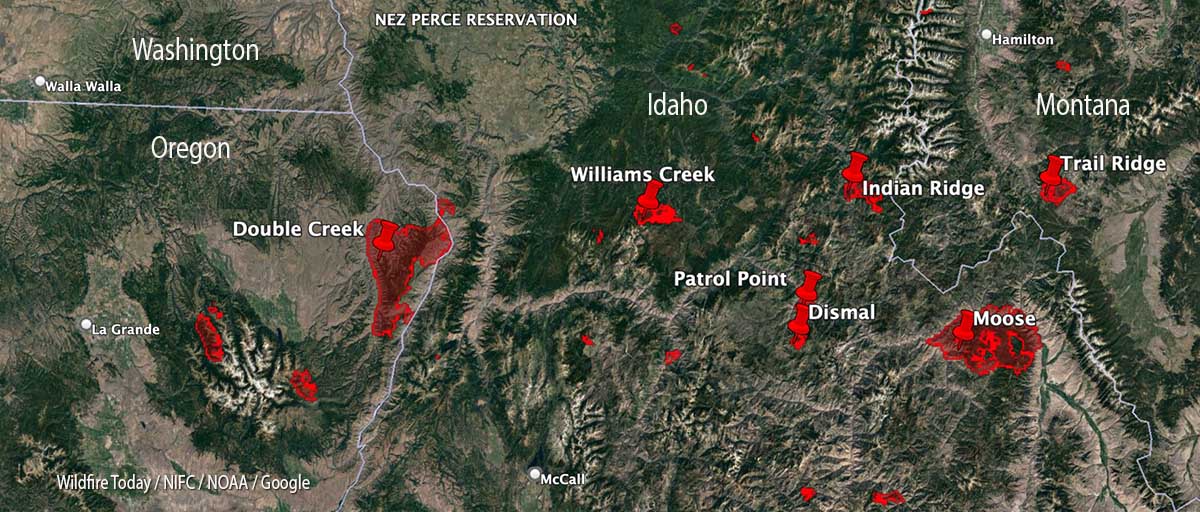
With 35 large uncontained wildfires currently burning in the United States, and many, many more in various categories, we can’t report extensively on all of them, so today we will take a slice of geography and look briefly at seven fires spreading in the Central Idaho area, and extend it just a bit into Oregon and Montana.
Moose (Idaho)
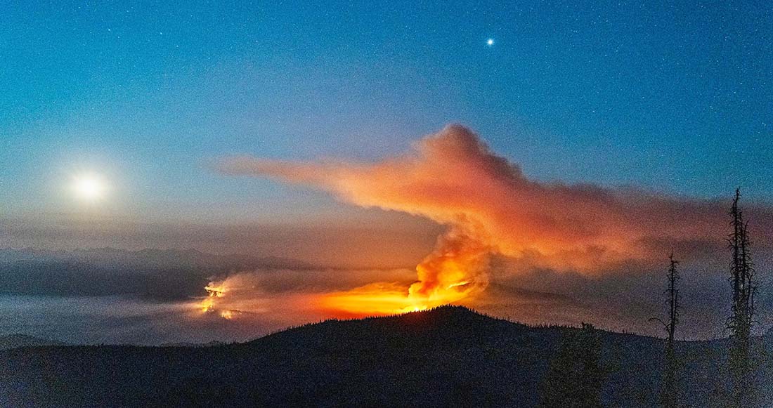
The largest of these seven fires is the Moose, which has been chewing through eastern Idaho since July 17. As far as the cause, the Salmon National Forest says, after almost two months, it is “human caused,” which only eliminates the causes of volcano and lightning. Nine structures have been destroyed. On Friday 650 personnel are assigned to the 125,000-acre blaze which is 5 miles northwest of Salmon, ID. A satellite overflight Friday afternoon only found large heat sources in the southeast portion and that is where an additional 15,000 acres burned Wednesday night, prompting evacuations near Salmon.
Crews reengaged the fire and began preparing new contingency lines along the west edge of the city. Several water pumps, five log decks, and some portable water storage tanks (nicknamed pumpkins because of their shape and color) were destroyed Wednesday. No firefighters were injured. Nearly 500 acres of the city’s Municipal Watershed burned that night, something the various incident management teams had been trying to protect since July.
Cooler temperatures, higher relative humidity, and thick smoke contributed to minimal fire behavior across the fire Thursday.
Indian Ridge (Idaho)
Northwest of the Moose Fire near the Montana border is the lightning-caused 8,670-acre Indian Ridge Fire on the Bitterroot National Forest. It is in the Selway-Bitterroot Wilderness 30 miles southwest of Darby, Montana. The fire has been active this week primarily along the western and northern flanks and north of Indian Creek as it burns through steep, rugged, remote terrain with heavy surface fuels and dead standing timber.
Indian Ridge Fire the night of August 18, 2022. InciWeb.
The fire is not being fully suppressed. Their daily reporting says, “Fire managers are utilizing a point protection strategy to prevent any critical wilderness infrastructure from being negatively impacted by the fire.”
Dismal and Patrol Point
These two fires are very close to merging after significant growth since September 6, and combined have burned an estimated 23,000 acres. They are about 50 miles northwest of Salmon, Idaho. Smoke and the unavailability of infrared mapping aircraft have made it difficult to determine the current perimeters, but there is a lot of new burned acreage between the two fires. Recent low humidity and strong winds are in part responsible for the recent growth.
Areas that fire managers intend to protect include Cold Meadows Guard Station, Root Ranch, and Lantz Bar.
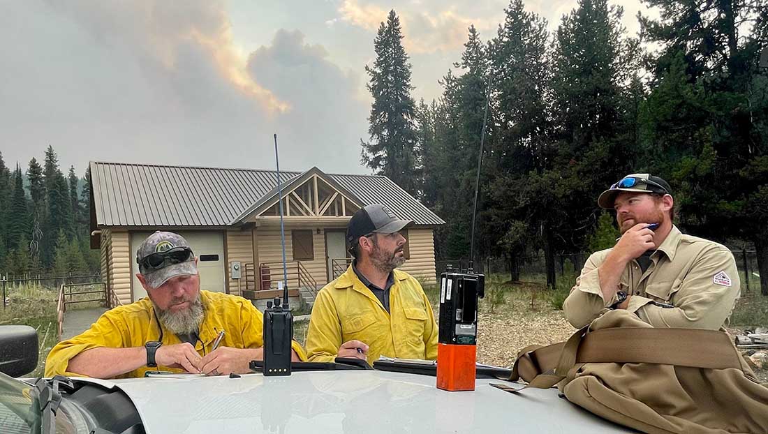
Fire personnel on the Williams Creek Fire in Idaho. InciWeb, posted 9-8-2022.
Williams Creek
The 11,881-acre fire is 5 miles west of Orogrande, near Wildhorse Lake, 7 miles southwest of Elk City, and 8 miles north-northwest of Dixie.
“Resources will continue to engage the fire in Orogrande and the Crooked River corridor, addressing and extinguishing hot spots and conducting damage assessments,” said a September 9 update from the Incident Management Team. “The fire and associated winds did impact structures and outbuildings; crews are still assessing the extent of the damage. Fallen trees, burned snags, and downed power lines continue to present safety hazards.”
Double Creek (Oregon)
The 137,000-acre lightning-caused Double Creek Fire is in Oregon just west of the Idaho border. It has burned to the Snake River in the Pittsburg Landing area. A River Group has been established to assess and protect structures along the waterway. The fire is being fully suppressed and crews are looking for locations to establish the control line farther from Lower Imnaha Road where topography allows. Two structures have been destroyed.
Trail Ridge (Montana)
The 13,000-acre Trail Ridge fire is on the Beaverhead-Deerlodge National Forest in Western Montana about 5 miles east of the Idaho Border and 4 miles southeast of Sula, MT. The cooler weather experienced Thursday and Friday was helpful in slowing the spread of the fire and decreasing the severity of fire behavior. It is burning above 7,000 feet elevation near the Continental Divide and there is no current or expected threat to private land and property. It is not being fully suppressed.
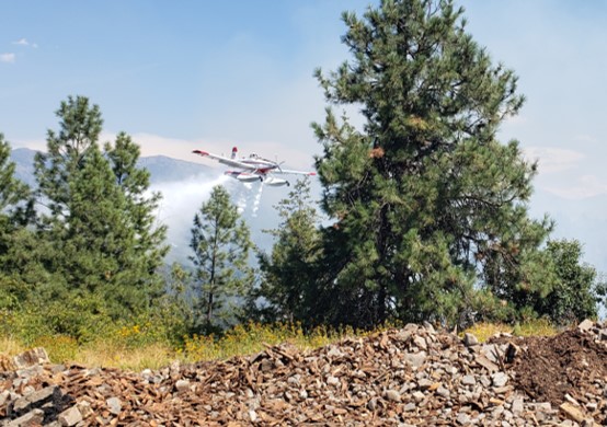
A single engine air tanker drops on the Moyie Fire August 21, 2022 near Moyie Springs, Idaho. Photo by Idaho Department of Lands.
Firefighters on the ground battling the Moyie Fire had to wait on aircraft support because a civilian drone was being flown in the area August 21 near Moyie Springs.
Aircraft ordered for the fire could not immediately fly because of the drone.
“The residents of approximately 50 homes in Moyie Springs were notified of the fire and the potential need for evacuation,” said Josh Harvey, Idaho Department of Lands Fire Bureau Chief. “Clearly, we needed to get air support for the firefighting effort as soon as possible and the drone put that on hold. Unfortunately this type of situation is not uncommon. We are reminding the public that drones can put firefighters, homes, and resources at risk.”
After the drone was gone, multiple firefighting aircraft went to work attacking the fire repeatedly while ground crews constructed a fire control line using hand tools. The fire was kept to three acres.
It is very dangerous to fly a civilian drone near a fire at which helicopters or fixed wing aircraft are operating. A collision could impact the windscreen or damage the engine, props, rotors, or flight control surfaces, causing a crash. If a drone is seen near a fire the standard operating procedure is to remove all aircraft from the fire area until it is confirmed that the drone has left the scene. In other words, it interferes with firefighting efforts.
It’s a federal crime punishable by up to 12 months in prison to interfere with firefighting efforts on public lands. Additionally, Congress has authorized the FAA to impose a civil penalty of up to $20,000 against any drone pilot who interferes with wildfire suppression, law enforcement, or emergency response operations. The FAA treats these violations seriously, and will immediately consider swift enforcement action for these offenses.