Red Flag Warnings and past 24-hour lightning, June 28, 2015

24-hour lightning by PSA
24-hour lightning by Predictive Service Area (PSA). Map obtained at 7 a.m. MT, June 28, 2015. (click to enlarge)

This map product, on the National Interagency Fire Center’s web site, is new to me. It is interactive, in that you can toggle on or off many different layers for weather and fuel conditions that affect wildland fire, including lightning, fuel moisture, fire danger, observed precipitation, forecast precipitation, Red Flag Warnings, and current weather conditions. Some of the layers don’t seem to be active, but maybe it is a work in progress.

The map above shows lightning over the last 24 hours by PSA. And yes, I had to research what “PSA” is. Apparently it stands for Predictive Service Area: “geographic areas of similar climate based on statistical correlation of RAWS data”. Unfortunately the lightning map does not include the date and time the data was current. And there is no explanation for the numbers that correspond to the colors, but I assume it is the number of lightning strikes.

The user interface for the site is a little cumbersome and at times non-intuitive, but after you figure it out it can be quite interesting.

Another product from the site is below — Red Flag Warnings for June 28, 2015.

wildfireRed Flag Warnings, June 28, 2015
Red Flag Warnings, June 28, 2015.

Lightning and high temperatures produce Red Flag Warnings

WildfireRed Flag Warnings, June 27, 2015

Forecasts for high temperatures and lightning with little or no rain on Saturday have resulted in Red Flag Warnings for areas in Oregon, Washington, California, and Nevada.

As shown in the map below, central Oregon received numerous lightning strikes during the 24-hour period ending at 6 a.m. MT, today June 27, 2015.

lightning map
Lightning, 24-hour period ending at 6 a.m. June 27, 2015. NIFC.

As of about 9 a.m. on Saturday, Central Oregon Fire reported 17 lightning fires had been discovered. The largest two were near Brothers, OR in grass or shrub; one was 200 acres and the other was 50 acres. The rest are small.

Record heat in the west may be followed by dry lightning

lightning near hot springs, sd
Lightning near Hot Springs, South Dakota, July 23, 2012. Photo by Bill Gabbert.

(UPDATED at 3:46 p.m. MT, June 24, 2015)

Isolated Thunderstorms

Isolated dry thunderstorms (with little or no rain) are predicted for some areas in northeastern California, western Nevada, and central Oregon Friday and into early Saturday morning. Land managers are worried about the possibility of new lightning-caused wildfires.

****

(Originally published at 9:59 a.m. MT, June 24, 2015)

Forecasters with the National Weather Service have published Special Weather Statements with warnings about extreme heat and lightning predicted for northern California, Oregon, and Washington beginning Thursday and through the weekend.

This interesting period will start with near-record, and record-setting heat on Thursday and Friday with high temperatures of 100 to 112 degrees in the valleys. Thunderstorms will be thrown into the equation starting on Friday, initially with little rainfall, raising the possibility for dry lightning. Later in the weekend there will be more moisture with the storms.


Alaska — 46,000 lightning strikes and many fires

(UPDATED at 12:22 p.m. MT, June 24, 2015)

Below is a list of fires in Alaska that are currently reported on InciWeb, sorted by size:

List of Alaska fires 6-24-2015

****

(Originally published at 9:09 p.m. MT, June 23, 2015)

Alaska Lightning
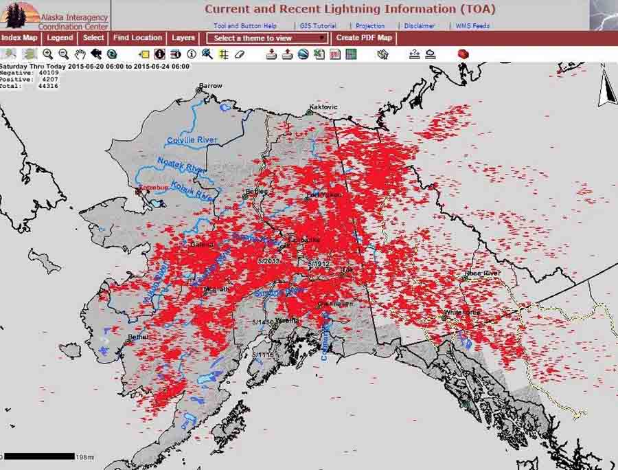
From Alaska Climate Info: This map shows the number of lightnings strikes in Alaska and western Canada since Saturday. The grand total was over 46,000 strikes. An average season has about 110,000 strikes. On Sunday, the Alaska Division of Forestry said that the 14,000+ lightning strikes was an all-time record (1986-present). On Monday an equal amount of strikes were recorded.
Note: Data can be found here:

A Facebook page called Alaska Climate Info has some amazing, even shocking, images of 46,000 lightning strikes in the state between Saturday and Tuesday morning, and a map showing dozens of fires that are larger than 5 acres each.

Alaska Fires, June 23, 2015
From Alaska Climate Info: Reader Tracy asked if there was a satellite image showing the smoke across Alaska. This image was captured yesterday by the Soumi-NPP (SNPP) satellite. The smoke in Interior Alaska stands out as a milky white. The bright white areas are thunderstorms and other high clouds. Active fires are shown as yellow dots.

In the image below, I believe each tag is a wildfire.

And from the National Park Service, more information about lightning caused fires in Alaska:

Denali fires
From the National Park Service: “Following a lightning storm… five wildfires are now burning in remote locations in Denali National Park and Preserve. None of the wildfires are threatening park structures or sensitive resources. Due to the remote locations, fire managers have opted to monitor these fires. http://bit.ly/1TMJ0JA

Lightning and Red Flag Warnings, June 10, 2015

wildfire Red Flag Warning, June 10, 2015Lightning, 24 hrs, 852 am June 10, 2015


The images above show Red Flag Warnings (on the left) that were current at 3:15 a.m. MDT, June 10, and lightning (right) for the 24-hour period ending at 8:52 a.m. MDT on June 10. The red icons represent the most recent lightning strikes.

Northern California, Washington, and Oregon can expect drier and breezy weather today with low humidities. With the lightning they received, it could be interesting there for firefighters over the next few days.

The map below, distributed by @BLMOregon Wednesday morning, was described as “lightning yesterday”. Click on it to see a larger version.

Lightning OregonThe next map shows Tuesday’s lightning in northern California — approximately 2,600 strikes, and 33 confirmed new fires in 6 National Forests as of Tuesday.

NorCal lightning


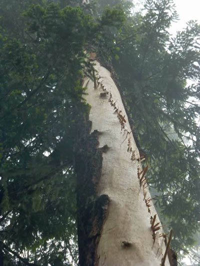
A lightning-struck tree on the Klamath

Lightning fire Photo

These photos of a tree that was struck by lightning were taken by USFS Forester Todd Drake on June 1 when he and his crew responded to a fire caused by lightning on the Klamath National Forest in northern California.

The amount of bark blown off by the strike is impressive. Sometimes the scar is only a few inches wide. This must have been a very powerful positive strike.

Lightning fire Photo

Lightning fire Photo