Village in Ontario with no road access being evacuated

The military is flying them out from a small airport nearby

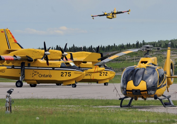
Ontario firefighting aircraft
Water-scooping air tankers and helicopters are being used across the province of Ontario. Photo by the Ministry of Natural Resources and Forestry.

(UPDATED at 2:56 p.m. CDT July 8, 2019)

The Chief and Council in Pikangikum, Ontario have ordered a full evacuation for the community due to a wildfire that has spread to within three kilometers of the town. All residents must register at the Pikangikum High School starting Tuesday at 7:00 am. .

The EOC is organizing flights, boats and a variety of evacuation methods. Residents will be evacuated to Red Lake initially and then marshalled to communities from there. Self-evacuees must also register in order to be put on the manifest and be supported.

Until Monday afternoon, evacuation was only recommended for elders, pregnant women, and anyone with respiratory issues.

The full evacuation will include thousands of residents.


(Originally published at 9:53 a.m. CDT July 8, 2019)

For the second time in just over a month a village in Northwest Ontario is being evacuated due to smoke from wildfires.

Pikangikum First Nation, with a population of several thousand, is in a remote area 87 k (54 miles) north of Red Lake with no road access except in the winter. Around the first of June residents vulnerable to smoke, including elders, pregnant women, and anyone with respiratory issues were flown out. The military landed a C-130 on the nearby 3,700-foot dirt runway north of the village to evacuate about 300 people.
Wildfires northwest Ontario
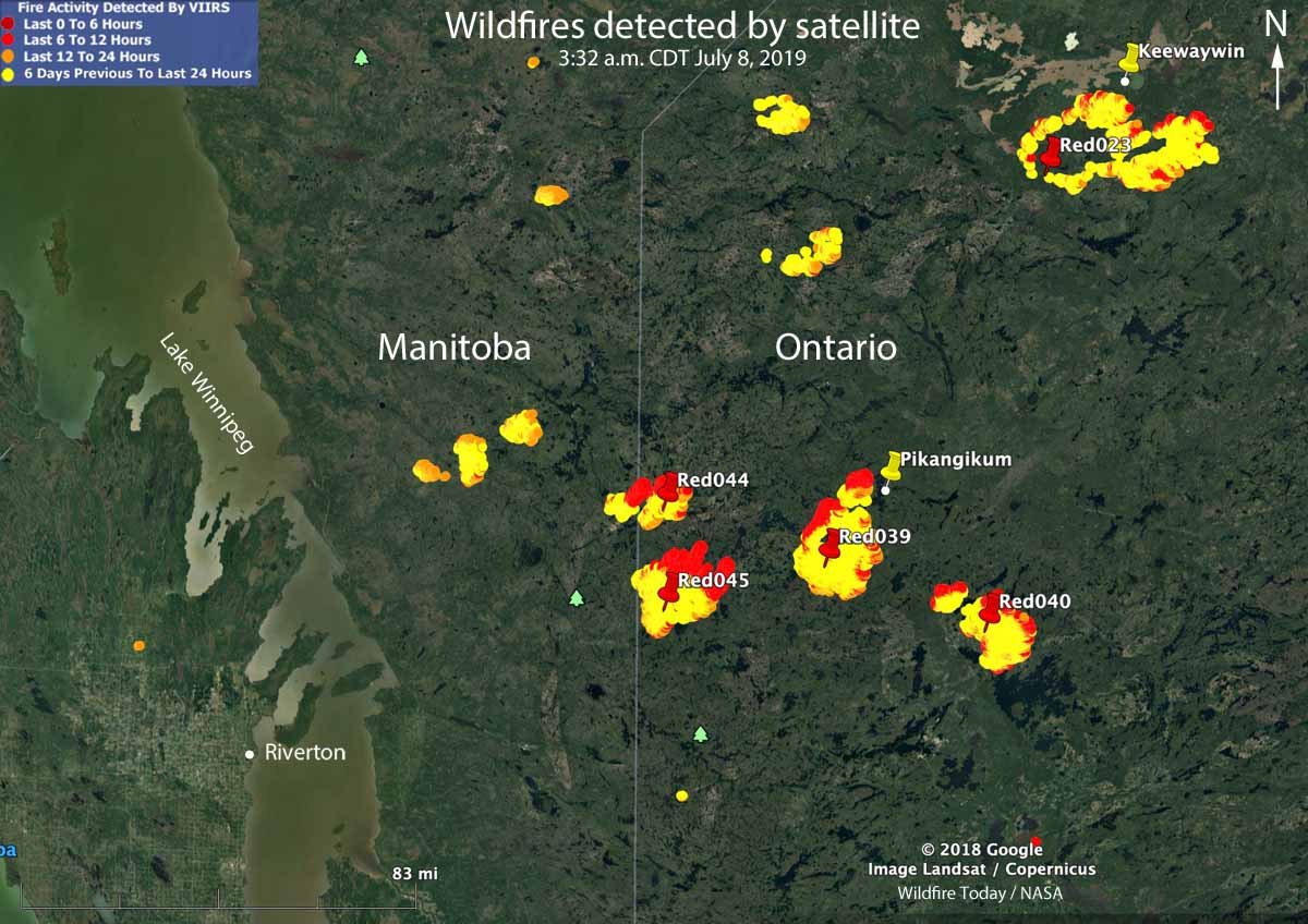
Map showing wildfires in northwest Ontario detected by a satellite as late as 3:32 a.m. CDT July 8, 2019.

With some of the residents having been back home for only a few weeks another fire, just 5 kilometers (3 miles) west of the community is forcing a repeat of the same scenario. For now, a lake separates the villagers from the fire, but not from the smoke. Officials are discouraging residents from self-evacuating by boat, saying it is not safe to do so.

The fire threatening Pikangikum is named Red Lake 39 and so far has burned over 40,000 hectares (99,000 acres). The fire is being managed by an incident management team as part of a larger cluster of fires. The team is looking for aerial ignition opportunities to tie the fire into natural boundaries. Sprinklers are being set up to protect structures.

That fire and several others in the area were very active Sunday and Sunday night, all of them running about  11 kilometers (7 miles) to the northeast (the red areas on the map above).

The Red Lake 23 Fire south of the community of Keewaywin has burned 71,993 (178,000 acres).

The Red Lake 40 Fire near Nungesser Lake has been mapped at 23,737 hectares (59,000 acres). It is 37 k (23 miles) northeast of Red Lake.

Wildfire activity increases in Manitoba and Ontario

The Red 023 Fire near Sandy Lake in Ontario made a 20 kilometer run Monday afternoon and night

wildfires Manitoba Ontario June 2 2019
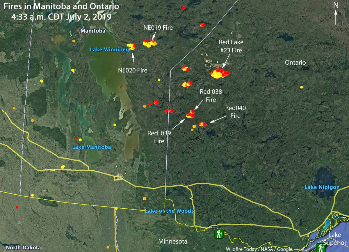
Map showing the locations of wildfires in Eastern Manitoba and northwest Ontario at 4:33 a.m. CDT July 2, 2019.

Wildfire activity in Canada has spread from British Columbia and Alberta, east to the provinces of Manitoba and Ontario. In the last several days about a dozen fires have grown much larger in Eastern Manitoba and Northwestern Ontario. Winds out of the west Monday afternoon and night forced some of blazes to grow substantially to the east and northeast.

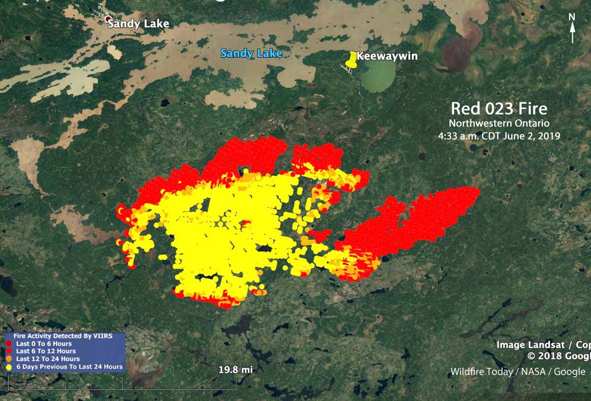
The largest in the area is in Northwestern Ontario, the Red 023 Fire that started June 15. As illustrated in the map below, between 2:42 p.m. July 1 and 4:33 a.m. CDT July 2 the fire ran east for about 20 kilometers (13 miles). Early Tuesday morning it was 4 miles south of Sandy Lake and six miles southwest of the community of Keewaywin.

The Ontario Ministry of Natural Resources and Forestry’s latest estimate of the size of the Red 023 Fire was 37,390 Ha (92,392 acres). After the major run, our very, very unofficial estimate using satellite data estimates that it has grown to at least 54,000 Ha (130,000 acres).

Map Red 023 fire Keewaywin Ontario Sandy Lake
Map showing heat on the Red 023 Fire detected by a satellite as late as 4:33 a.m. CDT July 2, 2019. The red areas burned between 2:42 p.m. July 1 and 4:33 a.m. CDT July2.

There are three large fires in Ontario northwest of Trout Lake that all started June 30. (See the map at the top of the article) The sizes were reported by the Ontario Ministry of Natural Resources and Forestry on July 1, 2019:

  • Red 038 Fire, 1,100 Ha (2,700 a)
  • Red 039 Fire, 10,000 Ha (24,700 a)
  • Red 040 Fire, 2,832 Ha (7,100 a)

Two of the larger fires in Manitoba are the NE 020 Fire and the NE 019 Fire, east of Lake Winnipeg and southeast of Playgreen Lake, both reported in mid-June. Their reported sizes are 11,000 Ha (27,000 acres) and 9,000 Ha  (22,000 acres), respectively.

The weather forecast for the Pikangikum, Ontario area through Saturday calls for temperatures in the mid to high 70s F, partly cloudy or sunny, winds generally out of the west during the day at 5 to 12 mph, and very little chance of rain.

The map below shows the forecast for the distribution of wildfire smoke from the fires in Alaska, Manitoba, and Ontario at 7 p.m. CDT July 3, 2019.

Smoke Forecast wildfires Canada
Forecast for the distribution of wildfire smoke at 7 p.m. CDT July 3, 2019, produced July 2 by the Canadian government. The forecast only includes the area within the black border.

The fitness test for Canadian firefighters

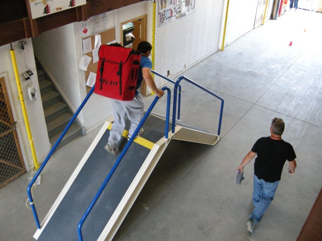
WFX-FIT test ramp
The ramp used in the WFX-FIT test

The two articles about the fitness test for wildland firefighters in the United States published yesterday on Wildfire Today have generated significant interest so far, judging from the number of comments left by our readers in the last 24 hours. The fitness test we are referring to is the Pack Test version of the Work Capacity Test which requires carrying 45 pounds (20.4 kg) for three miles on flat ground (4.83 km) in less than 45 minutes. Federal land management agencies in the U.S. and some fire departments require that firefighters pass the test each year in order to work on the fireline.

It was a coincidence that the two articles appeared on the same day. Rae Brook’s piece about a possible new and tougher version of a fitness test for hotshot crews had been in the pipeline for weeks and was just completed yesterday, about the same time that we received word of the unfortunate fatality of someone who was attempting to take the test two days earlier.

We learn a lot from comments left by our readers. “BC Initial Attack” informed us about the fitness test required of Type 1 Firefighters in Canada. The WFX-FIT, which first saw widespread use in 2012, is described as “a valid job-related physical performance standard used to determine whether an individual possesses the physical capabilities necessary to meet the rigorous demands encountered while fighting wildland fires.”

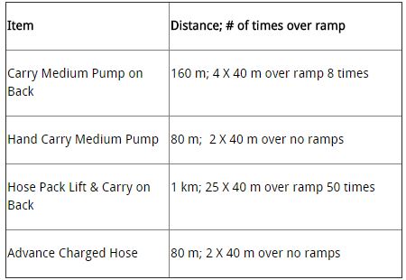
The components of the  WFX-FIT, after pre-participation screening are:

WFX-FIT circuits

The pump, or simulated pump, weighs 62.7 pounds (28.5 kg). The simulated hose that is dragged is represented by a 40.7 pound (18.5 kg) weighted sled. The hose pack weighs 55 pounds (25 kg).

WFX-FIT hose drag

Firefighters must be able to complete the test within 14 minutes and 30 seconds to be eligible for the National Exchange. The  Ontario Provincial Standard is 17 minutes and 15 seconds, the Alberta Provincial Standard is 14 minutes and 20 seconds, and the British Columbia standard is 14 minutes and 30 seconds. A score between 14 minutes and 31 seconds and 17 minutes and 15 seconds will meet the Ontario Provincial Standard but will not permit deployment outside of Ontario.

The photos are from the WFX-FIT website and the above video.

Ontario government sues railroad company for starting four fires

Timmins 9 Fire, May 2012
The Timmins 9 Fire burned about 20,000 hectares (98,000 acres) in May, 2012.

From CBCnews:

The province [of Ontario] is seeking compensation from Canadian National Railway over four forest fires in 2012, including $38 million for a massive fire near Timmins.

The province is alleging the fires were started by passing trains. The other three court actions involve another fires near Timmins, Chapleau and Thunder Bay. The damages sought in those cases are between $1 million and $2 million each.

The $38 million court action involves a fire called Timmins 9 in May of 2012.

The Ministry of Natural Resources and Forestry alleges the fire was started by the passage of a train through the area. The fire burned 40,000 hectares (98,000 acres) of bush and destroyed several camps.

The fire was the largest one in the province in half a century, and came within about 20 kilometers of the City of Timmins…

Documents filed in the case regarding the Timmins 9 Fire include the following:

14  The Ministry investigators also determined that the point of origin of the fire was within the railway right-of-way and approximately 2 1/2 metres from the western most rail at mileage 96.48.

16. At the point of origin, the investigators found a metal fragment whose particular characteristics indicated it had been heated and had been exposed to the elements for a short time.

17. Metal fragments are a competent source of ignition and may be released due to inter alia treading or wear or buildup from railway operations. This particular metal fragment, recently deposited, was a result of the railway operations of the defendant CNR.

The documents also accuse the railroad of failing to:

  • properly maintain, repair, and inspect the tracks and right-of-way;
  • properly maintain, repair, and inspect its railway cars, engines, and equipment including brake assembly and exhaust systems;
  • manage vegetation through controlled burns or other means;
  • provide a sufficient number of stations on its routes and personnel on the trains to detect and suppress fires;
  • control or extinguish the fire and failed to limit its spread beyond its property.