Firefighters making progress on Roosevelt Fire in Wyoming

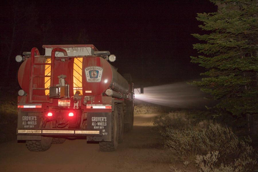
Above: Roosevelt Fire, Wyoming. InciWeb photo. Date and photographer not identified.

Firefighters have accomplished a great deal on the Roosevelt Fire since it started September 15 south of Bondurant, Wyoming but it has grown to over 60,000 acres, and only about half of the 172-mile fire perimeter has completed fireline.

The focus Sunday was on the southwest side of the fire in the North Dry Beaver Creek area west of Jim Bridger Estates. Firefighters have secured fire lines there, which reduces the threat. Additional resources have been allocated and a structure protection group is working the area ahead of the fire to protect homes.

On the north side of the fire adjacent to the highway, containment lines are in place and holding the fire south of the highway.

In Hoback Ranches, recovery efforts are underway in preparation of an organized repopulation of residents. Lower Valley Energy and Rocky Mountain Energy are working to restore destroyed infrastructure, while firefighters are clearing dangerous snags and suppressing hotspots as they occur. These efforts will continue for a number of days until it is safe for residents to return.

Personnel on the fire could receive help Tuesday night through Wednesday with a 30 to 70 percent chance of precipitation. There could be as much as a quarter-inch on Tuesday. From Thursday until Sunday the chance of additional precipitation is from 20 to 60 percent. Nighttime temperatures will be in the 20s and 30s.

Investigators determined that the fire was caused by an abandoned warming fire.

Highway 191 is fully open through the fire area with reduced speed limits and lane restrictions.
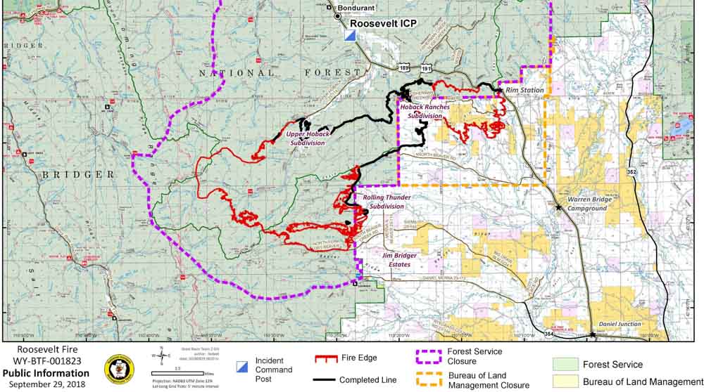
Map of the Roosevelt Fire
Map of the Roosevelt Fire, September 29, 2018. Click to enlarge.
Roosevelt Fire Wyoming
Roosevelt Fire. Photo by Kari Greer.
Roosevelt Fire Wyoming
A Firehawk helicopter executes a fancy water drop on the Roosevelt Fire in an area that is showing fall colors. Photo by Kari Greer.

Roosevelt Fire destroys at least 22 homes

The fire has burned over 50,000 acres 6 miles south of Bondurant, Wyoming

Above: A helicopter drops retardant near Rim Station on the Roosevelt Fire September 25, 2018. Inciweb photo.

After a survey Tuesday by the Sublette County Sheriff’s Office of 50 of the 153 homes in the Hoback Ranches subdivision, 22 were found to have been destroyed by the Roosevelt Fire. Property owners are being notified by the Sheriff’s Office. The fire is 6 miles south of Bondurant, Wyoming.

Wednesday while firefighters were conducting a burnout operation on the east side of the fire, Highway 189/191 was fully closed between Stinking Springs and Daniel Junction. The powerline along the highway has been shut down during the burnout, which affects the Kendall Valley and Upper Green areas.

Map Roosevelt Fire wyoming
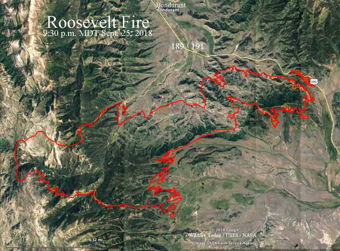
Map of the Roosevelt Fire. The red line was the perimeter at 9:30 p.m. MDT on September 25. The white line was the perimeter about 24 hours before. Click to enlarge.

On Tuesday the burnout near the highway was 2.2 miles long between Forest Road 30681 and Forest Lane.

Most of the significant growth on the fire Tuesday was on the east side within one to three miles of Highway 189/191. The rest of the fire exhibited low activity with no additional spread to the south, southeast, or west. In the area of Rolling Thunder, firefighters conducted burnout operations to further secure the fire edge. The fire did not move towards Jim Bridger Estates.

There was low fire intensity in the Upper Hoback and Kilgore Creek areas and firefighters continued to tie the open fire line into natural features to prevent fire movement east and west. In Hoback Ranches, firefighters knocked down hotspots to further secure homes in the area.

Resources assigned to the fire include 26 hand crews, 10 helicopters, 56 fire engines, 6 dozers, and 12 water tenders for a total of 982 personnel.

A Red Flag Warning is in effect in the area Wednesday for strong winds and dry fuels.

Roosevelt Fire approaches Highway 189/191

(UPDATED at 8:29 a.m. MDT September 25, 2018)

With the Roosevelt Fire approaching to within a quarter-mile of Highway 189/191 firefighters are again planning to conduct a burning operation on the southwest side of the road on Tuesday. They had hoped to start it Monday, but decided to postpone it.

The fire started September 15 and is 6 miles south of Bondurant, Wyoming.

Weather conditions Tuesday should be much more favorable than on Monday. After below freezing temperatures overnight, the forecast calls for 59 degrees, relative humidity in the teens, and west winds of 5 to 9 mph.

map Roosevelt Fire
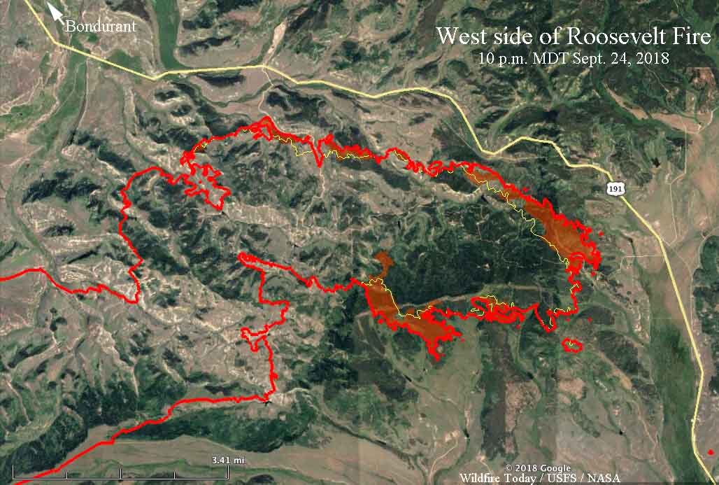
Map of the east side of the Roosevelt Fire. The red line was the perimeter at 10 p.m. MDT on September 24. The red shaded areas indicate intense heat. The white line was the perimeter about 24 hours before. Click to enlarge.

The fire grew by approximately 1,500 acres Monday to bring the total up to 49,805 acres. This was a smaller increase than in recent days, with most of the growth occurring on the east side where the perimeter roughly parallels Highway 189/191.


(Originally published at 6:27 p.m. MDT September 24, 2018)

Firefighters on the Roosevelt Fire 30 miles south of Jackson, Wyoming are attempting to fight fire with fire. Their goal Monday through Wednesday of this week is to use a backfire on the southwest side of Highway 189/191 to burn off the vegetation ahead of the fire, hoping it will serve as a barrier as the main fire spreads into the already burned vegetation.

On Monday it was a very difficult task, with 10 to 12 mph winds out of the west and northwest gusting at 20 to 26 mph. These conditions could increase the chance of spot fires across the highway from burning embers lofted by the strong winds.

map Roosevelt Fire
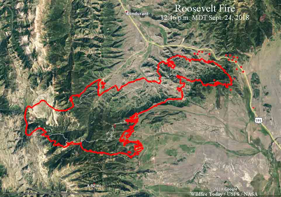
Map of the Roosevelt Fire. The red line was the perimeter at 9:20 p.m. MDT on September 23. The white line was the perimeter on Sept. 19. The red dots near Hwy. 189/191 represent heat detected by a satellite at 12:46 p.m. MDT September 24, 2018.

A Red Flag Warning is in effect for the area until 8 p.m. Monday. For Tuesday through Thursday the wind will decrease significantly. The temperatures will range from the teens at night to the 60’s during the day with little chance of precipitation. Those conditions should give firefighters a chance to make progress against the fire.

The fire is five miles south of Bondurant.

A mapping flight Sunday night at 9:20 determined that the fire had burned 48,348 acres.

Roosevelt Fire in western Wyoming grows to over 31,000 acres

One structure burned Wednesday night

(UPDATED at 4:31 MDT Sept. 20, 2018)

The 31,681-acre Roosevelt fire continued to burn aggressively into Wednesday night 30 miles south of Jackson, Wyoming. Most of the growth was on the south and east sides according to mapping conducted during the night. The fire is three miles from Highway 191 and six miles south of Bondurant.

Windy conditions Wednesday afternoon resulted in  numerous crown fire runs and occasional extreme rates of spread and flame lengths. One structure burned Wednesday night, but it was not specified if it was an outbuilding or residence.

map Roosevelt Fire Wyoming
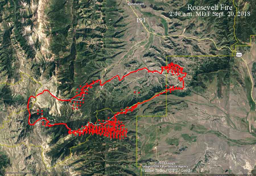
The red line was the perimeter of the Roosevelt Fire at 10:30 p.m. MDT September 19, 2018. The white line was the perimeter about 24 hours before. The red dots represent heat detected by a satellite at 2:40 a.m. MDT September 20.

Additional resources continue to arrive to assist the existing 259 personnel already on scene.

To see the all of the articles about the Roosevelt Fire on Wildfire Today, including the most recent, click HERE.

A Red Flag Warning is in effect Wednesday for relative humidity below 15 percent and afternoon winds from the west at 15 mph, gusting to 25 mph.

A update issued by the Incident Management Team September 20 stated “no injuries have occurred”. However on September 16 the Jackson Hole News & Guide reported that two civilians were seriously injured:

…They were caught in the area and forced to retreat into a creek. They were transported to St. John’s Medical Center, and as of Sunday night were being transferred to a burn center in Salt Lake City, according to a press release [Denise] Germann sent.

Ms. Germann was providing information about the fire for Grand Teton National Park and the Bridger-Teton National Forest.

When asked about injuries on the fire, Lorisa, a spokesperson for the Roosevelt Fire, said they are only reporting injuries that have occurred since the Incident Management Team presently in charge has been at the fire.

Thanks and a tip of the hat go out to Allen.
Typos or errors, report them HERE.

Two fires south of Jackson, Wyoming spreading rapidly at high elevation

The Roosevelt and Marten Creek Fires are 30 and 50 miles south of Jackson

Above: The Martin Fire, September 16, 2018. InciWeb.

(UPDATED at 7:02 a.m. MDT September 19, 2018)

The Roosevelt Fire 30 air miles south of Jackson, Wyoming was very active Tuesday growing to within 3 miles of Highway 191. Since it started September 15 it has spread 16 miles to the east. When it was mapped at 10:45 p.m. Tuesday the fire was 6 miles south of Bondurant. Most of the blaze at that time was within the Bridger-Teton National Forest but began to move onto private land on the east side near Muddy Creek Road late in the day.

To see the all of the articles about the Roosevelt Fire on Wildfire Today, including the most recent, click HERE.

The mapping flight Tuesday night determined the fire had burned approximately 25,168 acres, which was almost three times the size we estimated it had burned at 2:59 p.m. Tuesday.

3-D map Roosevelt Fire Wyoming
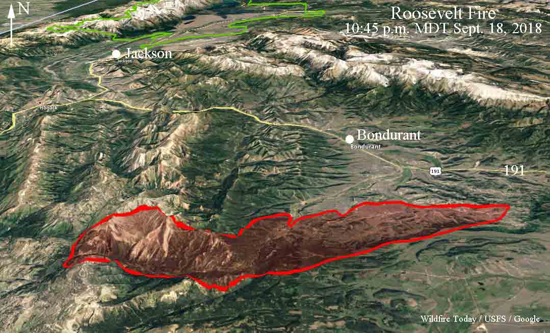
3-D map, looking north, showing the perimeter of the Roosevelt Fire at 10:45 p.m. MDT September 18, 2018.
map Roosevelt Fire Wyoming
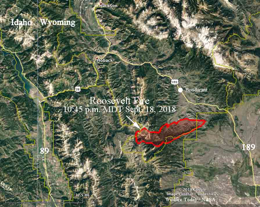
Map showing the perimeter of the Roosevelt Fire at 10:45 p.m. MDT September 18, 2018.

The Marten Creek Fire 50 miles south of Jackson was much less active Tuesday afternoon and evening.


(Originally published at 9:38 p.m. MDT September 18, 2018)

It is not every year that in mid-September we see wildfires south of Jackson, Wyoming spreading rapidly at 7,000 to 10,000 feet above sea level.

The Roosevelt Fire started September 15 about 30 air miles south of Jackson and spread to the east over a 10,000-foot ridge. At about 3 p.m. Tuesday it had spread along the east slope back down to 7,000 feet, 7  miles south of Bondurant.

The Great Basin Incident Management Team 6 led by Incident Commander Jeff Knudson will assume command of the fire Tuesday at 6:00 p.m.

Fire officials said it is a full suppression fire “utilizing natural barriers. These barriers will aid in slowing the fire growth. In other areas that are safe to have firefighters working direct, we will be using that tactic.”

The Sublette County Sheriff’s Office has issued Evacuation Orders for several areas. Their Facebook page has the latest official information.

Our very UNOFFICIAL estimate of the size of the Roosevelt Fire, based on heat detected by a satellite flying 200 miles overhead at 2:59 p.m. MDT September 18 puts it about 9,000 acres.

The Marten Creek Fire started near Gray River Road September 16, about 50 miles south of Jackson and has also worked its way up to a 10,000-foot ridge. It is 12 miles east of Afton, Wyoming. Strong winds aligned with the topography significantly increased the fire behavior Monday and Tuesday.

Tuesday evening a Type 2 Incident Management Team will begin transitioning with the local Type 3 team, in association with the U.S. Forest Service. The fire was human caused and is currently under investigation. Fire officials said Tuesday night the fire has burned about 5,700 acres.

The area will be under a Red Flag Warning Wednesday. The forecast for the fire area calls for a high of 70 degrees at 7,800 feet, winds out of the southwest at 15 mph gusting to 23, and relative humidity in the low teens.