Evergreen provides helicopters and the 747 “Supertanker” on contract to firefighting agencies. Now they are also offering an unmanned aerial vehicle that can obtain real-time imagery to firefighters on the ground. It can remain in the air for 20 hours at a time while transmitting the data back to Evergreen which then puts it on the Internet for firefighters.
But I’m not sure if the Federal Aviation Administration presently allows the use of UAVs over fires except in remote locations like Alaska, which Wildfire Today wrote about on August 27.
Fire Department Network News has a 3-minute video report about Evergreen’s UAV.
Here is a video of an unmanned aerial vehicle being used to gather intelligence about a fire in Alaska.
(THE VIDEO IS NO LONGER AVAILABLE)
From Wired.com:
Earlier this month in Alaska, a 40-pound Insitu Scan Eagle saw duty fighting wildfires after dense haze grounded conventional aircraft. The UAV is operated by the University of Alaska, which according to university officials is the first entity other than NASA or the Department of Homeland Security allowed to fly an unmanned aircraft beyond the line of sight in civil airspace.
The Scan Eagle — which is Boeing’s best-selling aircraft right now — was able to fly low over the fires through the thick smoke. Infrared cameras allowed people on the ground tracking the fires to find hotspots and monitor the fire lines.
Fire Department Network News has an interesting video report (no longer available) about the Aerial Firefighting Conference that was held February 19-20 in Garden Grove, California. This was the second of at least three that are planned. The first one was in Athens, Greece last year and the next one will be in Australia.
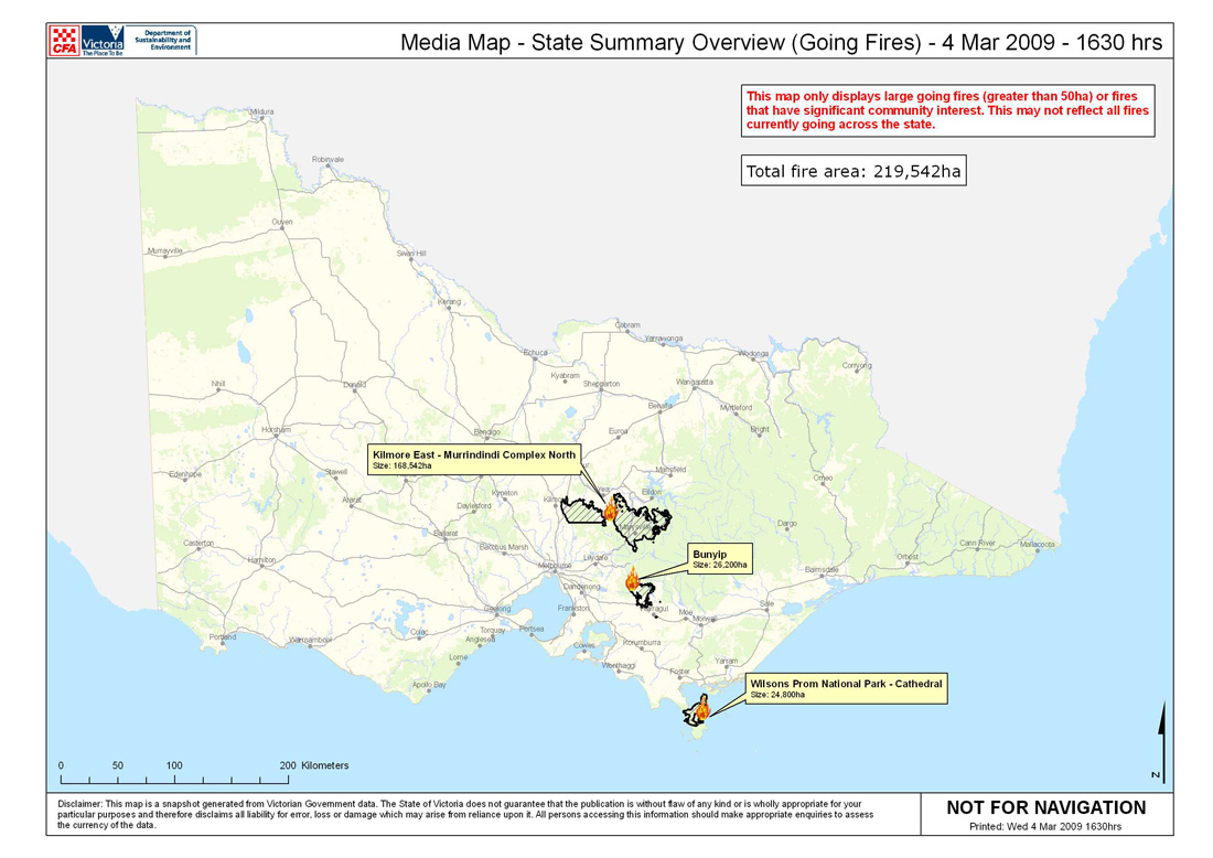
A map showing the current fires in Victoria, Australia late on Wednesday afternoon. Click on it to see a larger version.
Australia cancels order for Global Hawks
Global Hawk, Northrup Grumman photo
The Australian government canceled an order they had placed with Northrop Grumman for some Global Hawk unmanned aerial vehicles (UAV) because the delivery date was pushed back to 2015. They had planned to use the aircraft for monitoring bushfires and for maritime surveillance.
Defense Minister Joel Fitzgibbon said the order was canceled because the delay meant the arrival of the aircraft would conflict with the introduction of a new manned surveillance aircraft.
Senator David Johnston spoke out against the decision, saying they had been working on the project with the United States for 10 years, and:
“Plus it had a fantastic capability with respect to bushfire monitoring, and the Californians had been using it very successfully. I actually think it would have gone on to have been able to provide evidence as to arson.”
Occasionally in 2007 and 2008 the United States used a Predator B UAV operated by NASA for monitoring forest fires. In their flights the Predator stayed aloft for 10 to 20 hours while transmitting real-time data to ground forces.
UPDATE: January 8, 2013:
The Australian government has gone back and forth several times on buying or not buying these drones. The latest, according to radioaustralia.net.au in September, 2012, is that the the military wants seven large UAVs flying by 2019. The preferred option is a new, maritime surveillance version of the Global Hawk – the MQ4C Triton. The estimated cost of the project is between $2 billion and $3 billion.
NASA’s Predator B, called the Ikhana; NASA photo
Colorado: 6,500-acre Fort Carson fire
The Quarry fire that started Tuesday on the Fort Carson military base south of Colorado Springs has burned 6,500 acres and is 10% contained. Portions of the fire burned off the base into the city limits of Fountain, prompting some evacuations.
Yesterday the area had record high temperatures, and today there is a red flag warning for strong winds and temperatures in the 70s.
You may remember Fort Carson as the place where a single engine air tanker crashed last year, killing pilot Gert Marais.
Esperanza fire trial
The jury in the trial of Raymond Oyler, accused of setting the 2006 fire in which a U.S. Forest Service engine crew of five died, deliberated for a third day in southern California on Tuesday without reaching a decision.
Sprint asks for $2 billion for emergency communications network
Sprint Nextel sent a proposal to Obama’s transition team on January 6 asking the government to fund a $2 billion emergency network to improve communication among first responders during disasters.
The system would consist of 100 satellite-based light trucks and 100,000 mobile handsets to be staged at 40 sites around the country. Sprint claims the system could be programmed to be interoperable with existing public safety networks.
Fire on Moore Air Base
A 2,500 acre fire on the former Moore Air Force Base 14 miles northwest of Mission, Texas destroyed four structures, including one aircraft hangar. Initial estimates placed the damage to the base at $10 million.
A recent picture of Moore Air Base
The Air Force used the base for training pilots off and on between 1941 and 1962, when it was turned over to the U. S. Department of Agriculture to be used as a base for aerial screwworm fly control. It then became known as Moore Air Base. The USDA ceased using the base in 1982 and it is now a private airfield.
Esperanza fire opening statements expected on Thursday
Jury selection in the trial of Raymond Lee Oyler, accused of starting the fire that killed the 5-person USFS engine crew in 2007, is almost complete. An additional 80 jury candidates will be interviewed today, Wednesday, with Thursday being the likely day on which the actual trial will begin with opening statements. Oyler faces the death penalty and has been charged with 45 counts, including five first-degree murder charges.
The Press-Enterprise has been providing excellent coverage of this fire, the fatalities, and the legal proceedings.
Hydrogen-powered UAV may stay aloft for 7 days
The AeroVironment company is developing an unmanned aerial vehicle (UAV) named the Global Observer that will be powered by liquid hydrogen and will be able to cruise at 65,000 feet for up to 7 days. The primary use of the aircraft is for the military, but it may also be used for civilian operations including wildfires–for detection, monitoring, and communications.
AeroVironment, based in Monrovia, California, began testing a prototype of the 8-engine aircraft in 2005. It carries 1,000 pounds of liquid hydrogen which is converted to electric energy by an onboard fuel cell, generating electricity for the 8 ironless-core electric motors.
HERE is a link to a 1 minute 45 second video of a 2005 test flight of the Global Observer.
AeroVironment is the company that created the Helios UAV powered by sunlight and batteries which could stay aloft for days at a time. It had massive amounts of photovoltaic cells embedded on the top of the wings and flew unmanned on solar power alone up to 96,863 feet, setting a record in 2001 for sustained horizontal flight by a winged aircraft. It crashed in 2003 off the coast of Hawaii after encountering turbulence.
Helios solar-electric-powered UAV
Helios disintegrates as it falls into the Pacific Ocean
Marvel Comics has created a number of comic books in tribute to our military. Their latest, released free to the military in July, features military personnel, several super heros, MAFFS air tankers, the Ikhana unmanned aerial vehicle (for mapping fires), and a fire which is threatening San Diego.
Above is one page out of the book. The author of the comic book, Stuart Moore, blogged about his creation HERE.
The EurekAlert has a summary of a recent report by the U.S. Forest Service. Here is an excerpt:
The effectiveness of the media to inform the public during evacuations and wildland fire effects on recreation are some topics addressed in a U.S. Forest Service report published this month that is a compilation of 17 studies on the social science aspects of fires.
More than 20 scientists present their work in the 260-page report, entitled “Fire Social Science Research From the Pacific Southwest Research Station: Studies Supported by National Fire Plan Funds.”
The report’s communications research showed the emergence of citizen news producers when public information officers and media representatives do not fill homeowner needs for detailed, real-time information on fire location, size and movement.
“During the initial stages of a fire, people want real-time information specific to a location, such as a subdivision,” said Deborah Chavez, a Forest Service social scientist who helped conduct research in the report.
According to one study, cell phones, digital cameras, text messaging, blogs, personal websites and e-mail vastly improved homeowners’ ability to communicate with their neighbors, during evacuations in 2003 near San Bernardino, Calif.
Residents complained public information officers were preoccupied reporting on which agencies were managing fires, firefighting resources being used and suppression costs. They also said media coverage was often sensationalized, inaccurate and directed to regional audiences and not those affected by local evacuations.
One problem that needs to be solved is how to provide near-real-time information to residents whose safety is impacted by a wildland fire. In the 2003 Cedar fire near San Diego 15 civilians were killed–many of them while trying to evacuate from the Wildcat Canyon Road area with little or no warning. Many civilians were also killed while trying to evacuate from the Tunnel fire in Oakland in 1991. At least twice this year alone people have been burned to death in their homes when a wildland fire burned through their neighborhood.
Making real time information about the fire’s location available, interpreting that data to decide what areas should evacuate and which areas are safe, then providing this data to the public in near-real-time is not a small task. But it could be argued that this should be the most important objective of fire managers, above and beyond the boiler-plate written into every Incident Action Plan of “provide for the safety of the public and firefighters”.
Picture this.
A large fire is directly impacting an urban interface. Unmanned aerial vehicles or other aircraft are 10,000-50,000 feet over the fire 24 hours a day transmitting real time infrared and conventional visual imagery to the Incident Command Post (ICP). Technicians and infrared interpreters are evaluating the data, again in real time, and creating a map showing the fire’s perimeter. Fire Behavior Analysts provide fire spread predictions. An Operations Section Chief at the ICP evaluates all of this information and communicates with the Situation Unit Leader, Division Supervisors, Field Observers, and the Ops Section Chief in the field. Working with the Incident Commander he or she makes decisions about what areas should be evacuated and informs law enforcement to implement the evacuations.
Law enforcement activates reverse 911 to robo-call all of the landline phones in the affected area and sends officers into the field to notify residents to evacuate, but they can’t contact everyone.
The Situation Unit uploads to the Internet a map showing the current location of the fire and which areas are under an evacuation order. This map is available to the world and is updated every 15 minutes if needed. The map could be based on Google Maps, be zoom-able, show evacuation routes, shelters, and have interactive features, rather than the typical static .pdf or .jpg file that incidents usually produce.
The Information Officer’s staff maintains a public blog, updated many times each day, containing the information that the public needs to know. More emphasis is placed on keeping the citizens safe, than providing the number of engines and helicopers assigned to the fire.
All of this technology exists now. It would not take a Manhattan Project to make it happen.
UPDATE September 23: A county in Montana has taken a step in the right direction. Read about it HERE.