Three significant new fires in Washington

(UPDATED at 5:34 p.m. PT, July 21, 2015)

Today much of the eastern part of Washington is again under a Red Flag Warning until 8 p.m. for westerly winds of 15 to 25 mph and a relative humidity of 10 to 20 percent.

I-90 Fire between Vantage and George
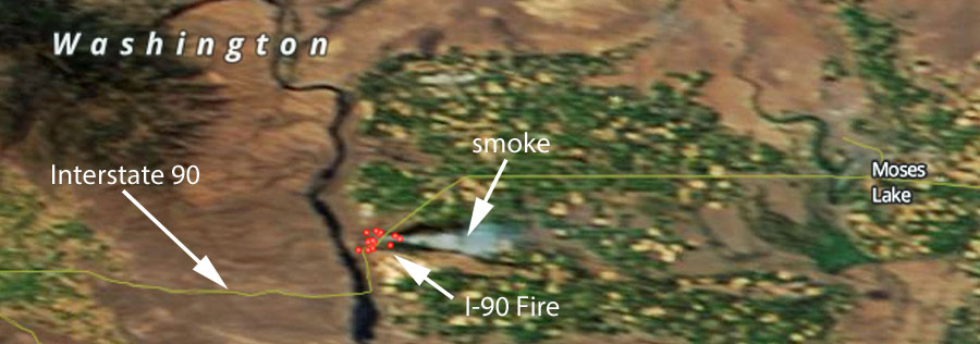
I-90 Fire July 20, 2015
Satellite image showing the location of the I-90 Fire July 20, 2015 (click to enlarge)

We have seen this referred to as the “I-90 Fire” today. It has burned about 900 acres and has a state Type 3 incident management team assigned. Interstate 90 has been subject to intermittent closures and at 7 a.m. on Tuesday was closed.

Blue Creek Fire

UPDATE at 5:34 p.m. PT, July 21, 2015: 

The Blue Creek Fire has grown to 4,000 acres, the Union-Bulletin reports, and has destroyed one residence on Klicker Mountain Road and seven outbuildings near the intersection of Klicker Mountain Road and Blue Creek Road. More areas are threatened including the Bluewood Ski area and the Mill Creek Watershed.

The Union-Bulletin has a gallery of excellent photos of the fire.

****

A helicopter working on the Blue Creek Fire 10 miles east of Walla Walla, Washington, had a mechanical failure while in flight Monday evening, according to the Union-Bulletin which quoted Heather Lee of Walla Walla County Emergency Management. The pilot autorotated the helicopter and walked away from the incident. He refused to be transported to an hospital, Ms. Lee said. Fire Aviation has more information about the helicopter incident.

mapBlue Creek Fire
The red, yellow, and brown squares represent the location of heat detected on the Blue Creek Fire by a satellite at 12:45 p.m. July 21, 2015. The map is looking north, and Walla Walla can be seen on the left side. (click to enlarge)

The fire has grown to 2,500 acres due to extreme fire behavior and long-range spotting. Very little information is being provided by the Washington DNR, but they reported that 32 engines and 3 helicopters are assigned, and eight structures have burned . Evacuations and road closures are in effect.

Colvin Creek Fire, now part of the PC Complex of five fires

A Type 2 incident management team (Leitch/Holloway) is assigned to this complex which has burned 100 acres. Very little information is being provided about this complex of fires.

****

(Originally published at 4:43 p.m. PT, July 20, 2015)

Three new fires have erupted in Washington recently. Much of the state is under a Red Flag Warning on Monday.

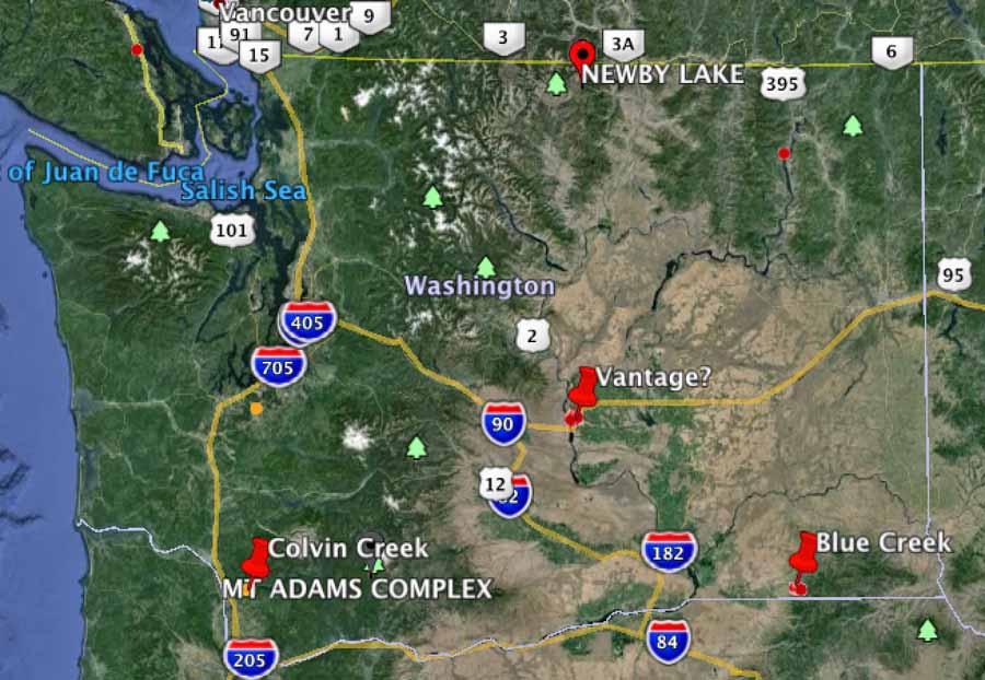
Washington fires, 7-20-2015

Fire between Vantage and George

On Sunday a fire between Vantage and George required the closure of Interstate 90. Later in the day it reopened, but on Monday the fire awakened, or it may be a new ignition in the same area — reports are unclear at this point. But the Interstate is again closed between mileposts 138 and 149 and approximately 50 structures are being evacuated.

KOHO radio reports it has burned 700 to 800 acres.

Blue Creek Fire

The Blue Creek fire is causing evacuations along Blue Creek Road 10 miles east of Walla Walla. Monday afternoon the Blue Mountain Interagency Dispatch Agency Center said it had burned at least one structure and about 350 acres of vegetation. Several air tankers were working the fire Monday afternoon.

You can listen to some of the radio traffic at an online scanner.

Colvin Creek

Monday morning the reported size of the Colvin Creek Fire was 70 acres, and a Type 2 Incident Management Team, WA Team 5 (Leitch/Holloway), was responding. The fire is 11 miles southeast of Kalama.

How fire spreads in the Olympic rain forest

This video illustrates how the Paradise Fire is spreading through the rain forest in Olympic National Park in Washington. The fire easily climbs up the lichen and moss on a tree then drops burning embers to the ground or onto an adjacent tree branch where it can continue to spread.

The fire started May 5 and has burned 1,520 acres. It is being managed by a team from the National Incident Management Organization (NIMO).

Washington’s wildfire season off to an early start

Sleepy Hollow Fire map
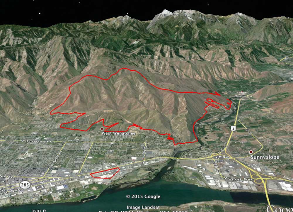
3-D map of the Sleepy Hollow Fire in Wenatchee, Washington, looking west, 1 a.m. PT, June 30, 2015. Note the spot fire near the river that is 1.2 miles east of the main fire. (click to enlarge)

The Sleepy Hollow Fire that swept into Wenatchee, Washington destroying 29 homes announced the early beginning of the wildfire season in the state. A spot fire 1.2 miles in front of the main fire that for a while was not noticed while structures were burning on the other side of town, spread into four industrial buildings.

The Los Angeles Times has an interesting article about the fire and the current situation in Washington that has led to concern about how the state will deal with the conditions this summer, and beyond. Below are excerpts from the article:

…”This is a stress test for 2070,” said Cliff Mass, a professor of atmospheric sciences at the University of Washington. “We’re being tested now with the warmth and lack of snowpack that will be typical at the end of the century. How do we get through it?”

Climate experts say the current conditions in the Pacific Northwest are part of a short-term climate phenomenon, but they warn that temperatures are rising everywhere. In Seattle, for example, that means warmer, wetter winters and warmer, drier summers.

[…]

Two months ago, Democratic Gov. Jay Inslee declared a statewide drought emergency, a snowpack drought rather than a precipitation drought. At the time, state officials warned that the 2015 fire season could be earlier and fiercer than Washington has ever seen.

Now that it has begun in earnest, “it’s worse than I feared,” Goldmark said.

[…]

Sitting on the tailgate of a pickup truck in front of what had been her home of 18 years, Sharon Cooper marveled Wednesday that all of the precautions she and her husband, Nick, had taken through the years did no good against the Sleepy Hollow fire.

Not the concrete shingles. Not the backyard fire hose with high-pressure water. Not the regular efforts to whack away the brush.

“This is August kind of stuff,” Cooper said, mourning the community’s loss, wondering whether she and Nick would rebuild. “Even sometimes the Fourth of July is rainy and yucky here…. Everything’s changing.”

Another article worth your time is titled Large, early blazes in unusual places are shaping this year’s wildfire seasonThe piece in the MinnPost looks at the general wildfire situation in the United States and Canada. A brief excerpt:

…As of Monday, according to the CBC, Saskatchewan had 112 active fires across the province, bringing the year-to-date total to 569. That’s nearly three times the tally for 2014, and the acreage in flames is 10 times a normal year’s.

The newest fires near La Ronge, toward the northern fringe of settlement in the province, prompted evacuation of 8,000 more people, bringing to 13,000 the number waiting out the battles in emergency shelters — the largest evacuation in provincial history. More than half of them had to be lodged in neighboring Alberta…

Music video about Carlton Complex Fire of 2014

The song and the photos in the video are about the largest wildfire in the recorded history of Washington — the 256,108-acre Carlton Complex of Fires. In July, 2014 it burned approximately 300 homes in and around the towns of Pateros and Malott as well others in more rural areas.

The video is very well done, beautifully sung by Brittany Jean, and is quite moving.

Thanks and a tip of the hat go out to Jim.

Washington Lands Commissioner: state legislators “didn’t seem to care about the public’s safety”

The Commissioner of Public Lands in Washington State is very disappointed that the legislature approved only one-third of the increase he requested to beef up the number of fire engines and helicopter crews in the Department of Natural Resources for initial attack on new fires.

Below is an excerpt from an article in the News Tribune:

State lawmakers didn’t hesitate to pay $70 million to cover the costs of fighting last year’s wildfires after the flames died down.

But now, as wildfires again rage across the state, the head of the state’s chief wildland firefighting agency says he’s frustrated the Legislature wouldn’t pay a fraction of that amount to help stop new fires from getting out of control.

Commissioner of Public Lands Peter Goldmark said he got less than one-third of what he requested for early fire response in the state’s new two-year budget, which Gov. Jay Inslee signed into law late Tuesday.

“The Legislature has left me in a precarious position, with what I view as insufficient resources to meet the threat,” said Goldmark, who leads the state Department of Natural Resources. “Even in the face of (the current fires) and the threat to public safety that those fires contained, the Legislature didn’t seem to care about the public’s safety at all.”

[…]

On Friday, the Northwest Interagency Coordination Center reported more than a half-dozen large fires active throughout the state.

Fires scorched more than 400,000 acres in 2014, the most destructive fire season in state history.

Following that record-setting fire season, Goldmark requested more funding from the Legislature to staff additional fire engines and helicopter crews — about $4.5 million above what the agency received in its previous two-year budget for fire response. Yet in the state’s new $38.2 billion spending plan, Goldmark got only $1.2 million of the extra funding he requested.

Spot fire from Sleepy Hollow Fire burned commercial structures 1.2 miles from main fire

Sleepy Hollow Fire map
3-D map of the Sleepy Hollow Fire in Wenatchee, Washington, looking west, 1 a.m. PT, June 30, 2015. Note the spot fire near the river that is 1.2 miles east of the main fire. (click to enlarge)

The map above is a 3-D rendering of the perimeter of the Sleepy Hollow Fire that burned into Wenatchee in central Washington Sunday, June 28. The map is looking west, and was produced after a mapping flight at 1 a.m. PT, July 1. The fire burned 24 residences and several commercial structures.

One interesting thing is the spot fire that caused several businesses to burn near the river 1.2 miles away from the main fire. It is believed that a burning ember landed in some bales of cardboard that were to be recycled. While firefighters were engaged miles away trying to save homes, the fire spread from the cardboard to several nearby commercial structures, some of which were warehouses and fruit packing plants. Monday morning, June 29, smoke was still coming from the facilities of Michelsen Packaging Company, Northwest Wholesale, and Blue Bird Inc.

This is not unheard of, for a burning ember to travel that far and ignite a new fire, and has happened over greater distances. A recent example was on the King Fire in northern California in 2014, where a spot fire occurred 2 miles in front of the main fire.

More information about the Sleepy Hollow Fire on Wildfire Today.