Homes burn in Wenatchee, Washington wildfire

(UPDATED at 7:32 p.m. PT, July 1, 2015)
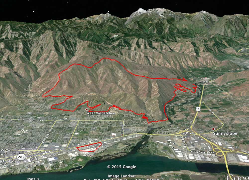
Sleepy Hollow Fire map
3-D map of the Sleepy Hollow Fire, looking west, 1 a.m. PT, June 30, 2015. Note the spot fire near the river that is 1.2 miles east of the main fire. (click to enlarge)

The map above is a 3-D map of the Sleepy Hollow Fire in central Washington, looking west, produced after a mapping flight at 1 a.m. PT, July 1.

One interesting thing is the spot fire that caused several businesses to burn near the river. It was 1.2 miles away from the main fire. This is not unheard of, for a burning ember to travel that far and ignite a new fire. It has happened over much greater distances.

A recent example was on the King Fire in northern California in 2014 — a spot fire occurred 2 miles in front of the main fire.


****

(UPDATED at 10:58 a.m. PT, June 30, 2015)

The Sleepy Hollow Fire 95 air miles east of Seattle has been mapped at 2,995 acres. The incident commander, according to @jwhittenbergK5, confirms that 24 residences burned.

Heavy rain Sunday evening stopped the spread of the fire, however the industrial facilities continued to burn.

****

(UPDATED at 9:38 p.m. PT, June 29, 2015)

Fire officials are reported at 3:35 p.m. on Monday that the Sleepy Hollow Fire that spread into Wenatchee, Washington burned 24 to 28 residences, and that a more accurate count will be available when fire crews are able to access the entire burned area. They are estimating the size at 4,000 acres.

Wenatchee is in central Washington, 95 air miles miles east of Seattle.

Approximately four businesses also burned, some of which were about a mile from the main fire. The suspicion is that burning embers landed in some bales of cardboard that were being recycled and that fire spread into the industrial structures.

****

(UPDATED at 4:03 PT, June 29, 2015)

The Wenatchee World has a gallery of photos showing the neighborhoods that burned.

Rain on Monday, heavy in some areas, will make the job of firefighters much easier. The precipitation even caused a mud slide that closed Highway 2 near the mouth of Pine Canyon shortly after 3 p.m.

****

(UPDATED at 11:42 a.m. PT, June 29, 2015)

As you will hear in the video above, the number of structures burned in the Sleepy Hollow Fire in Wenatchee, Washington has been revised upward, from 24 to 28.

****

(UPDATED at 9:30 a.m. PT, June 29, 2015; originally published at 8:53 a.m. PT, June 29, 2015)

Approximately 24 structures have burned in a rapidly spreading wildfire in Wenatchee, Washington, reports Jake Whittenberg of King 5 News. The Sleepy Hollow Fire started Sunday afternoon, June 29 and by Monday morning had burned 3,000 acres. The number of structures destroyed could change as firefighters are able to get a better look at the damage caused by the fire in central Washington 95 miles east of Seattle. More than 1,000 people have been forced to evacuate, including a Walmart store in the north part of town.

Strong winds on Monday afternoon and triple-digit temperatures helped spread the fire quickly from where it started three miles west of town through sage and grass into a “pretty dense urban interface area”, said deputy state fire marshal Bill Slosson.

Some of the structures that burned were warehouses and fruit packing plants. Monday morning smoke was still coming from the facilities of Michelsen Packaging Company, Northwest Wholesale, and Blue Bird Inc.

“The city is asking residents to severely curtail water use”,  Carl Buick, who lives nearby, told Wildfire Today. “This is significant because we have a robust water system and supply. The reservoirs have been severely drawn down.”

The fire was still very active through Sunday night, but firefighters hoped rain falling Monday morning would help them corral the devastating fire.

A weather station 14 miles north of the fire recorded 0.01″ of rain at 7:24 a.m. Monday morning, but there was a report of heavier rain at the fire. That same station reported a high temperature of 111 degrees on Sunday. Most of Washington, including the Wenatchee area, is under a Red Flag Warning on Monday for gusty winds and the possibility of dry lightning, which could ignite more fires.

The video below is from a Sunday night newscast.


A Type 2 incident management team has been ordered.

Wildfire burns in Olympic rain forest

(UPDATED at 11:51 a.m. PT, July 3, 2015)

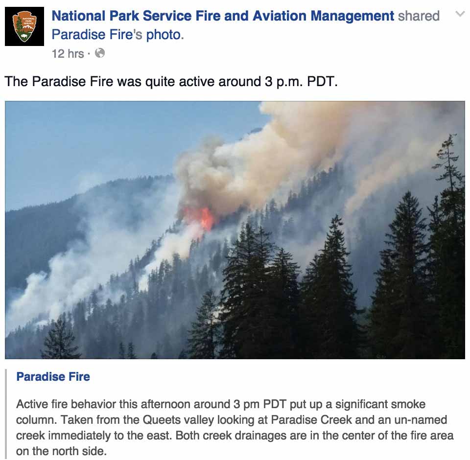
This photo and Facebook post are from July 2, 2015.

Paradise Fire July 2, 2015

****

(UPDATED at 11:15 a.m. PT, June 29, 2015)

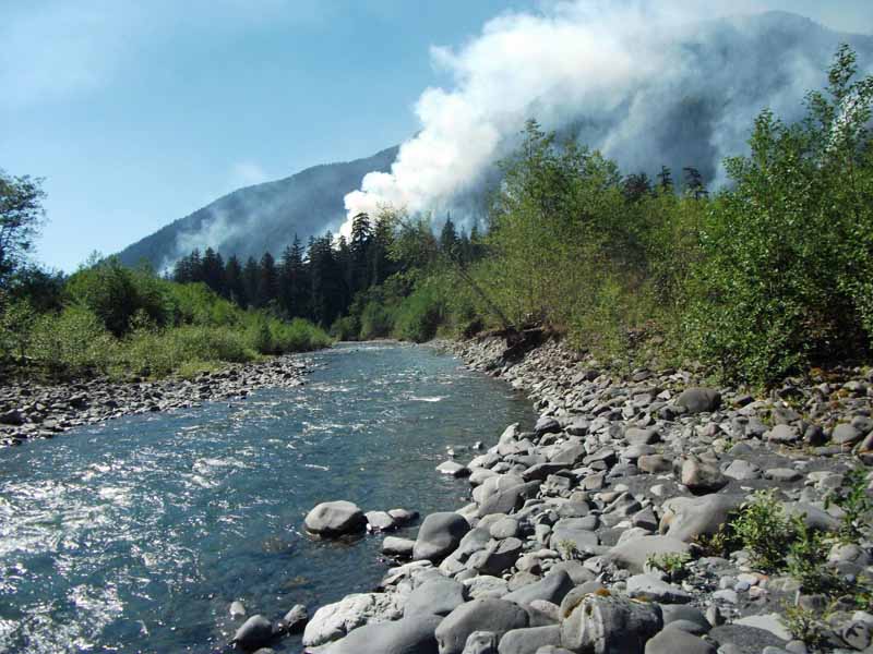
Paradise Fire
Paradise Fire. Undated NPS photo.

Below is an update on the 1,025-acre Paradise Fire in Olympic National Park, released Monday morning, June 29.

****

“Crews on the Paradise Fire reported moderating weather and limited fire growth on Sunday, a change from the previous several days of high temperatures and low relative humidity. While other parts of the Pacific Northwest experienced lightning and thunderstorms, only intermittent sprinkles fell on the fire area. A smoke inversion also contributed to a quieter day. Yesterday’s highlight for fire crews camped out in the Queets River drainage was the delivery of a satellite communications unit. This will allow the firefighters to keep in closer contact with fire management officials at the Incident Command Post in Port Angeles. The unit improves safety conditions by giving the crews access to maps and creates more secure communications links in the event of an illness, emergency, or other situation that requires increased coordination of fire management activities. It also provides a convenience of telephone and internet contact with the outside world.

Yesterday’s milder weather conditions will be repeated for the next two days as a high pressure system breaks down and is replaced by an upper level low that should last until Tuesday. However, high temperatures and increased fire potential return mid-week and are expected to remain through the upcoming 4th of July holiday weekend. Crews will continue their work to confine the fire north of the Queets River.

Olympic National Park has instituted a ban on open fires in the park’s wilderness backcountry, including all locations along the coast. Campfires are permitted only in established fire grates at established front country campgrounds. The burn restriction will remain in place until further notice. Camp stoves may still be used in the park’s wilderness backcountry, but should be operated well away from flammable vegetation and forest litter. Because of the extreme conditions on the peninsula, Olympic National Forest has also implemented fire restrictions.

Information on this fire can be obtained on Inciweb athttp://inciweb.nwcg.gov/incident/4305/, and by calling Paradise Fire Information at 360-565-2986. For real time information, visit the Paradise Fire Facebook page at: https://www.facebook.com/pages/Paradise-Fire/831205013596015.”

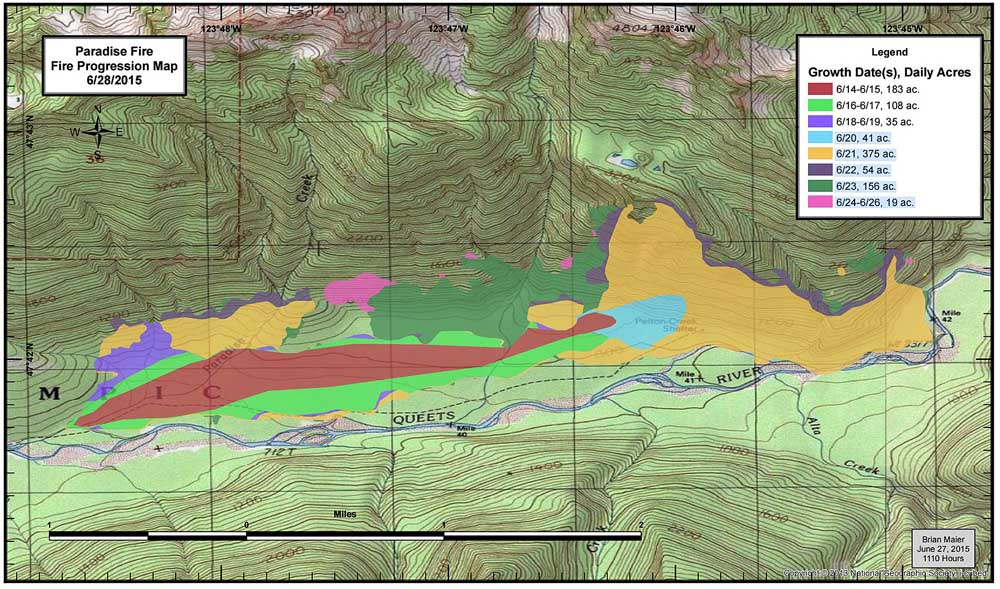
Paradise Fire progression map June 28, 2015

****

(UPDATED at 11:12 p.m. PT, June 24, 2015)

The managers of the Paradise fire in Olympic National Park said today, after two recent infrared mapping flights, that the fire has been steadily moving uphill, and has now burned 949 acres.

The following photo was posted on the Facebook page of the Missoula Smokejumper Visitor Center with this caption: “Good sized trees on the Paradise fire in North Cascades National Park. This fire was jumped by Redmond and NCSB jumpers. credit: @ppbutton”. They may have meant the fire was in Olympic National Park. The firefighter in the photo, possibly a jumper, appears to be traveling light.

Paradise Fire big trees

****

(UPDATED at 3:39 p.m. PT, June 23, 2015)

Olympic NP weather

@OlympicNP Tweeted the above graphic above, saying:

A graph from the fire assessment team tells it all. May/June 2015 holds the record since 1895 for the driest on record.

You can click on the graphic to enlarge it slightly.

Here is an update posted by the Park on Tuesday:

Yesterday, clouds slowed activity on the Paradise Fire throughout the morning hours; fire activity increased when the clouds lifted in the afternoon. The fire remains north of the Queets River and the west flank is holding well. It continues to move to the east-northeast and into the high country where the terrain is exceptionally steep and inaccessible. Helicopters used bucket drops to cool the northwest corner. A reconnaissance flight in the late afternoon allowed fire managers to get a better view of the fire’s movement. An infrared flight last night revealed the fire’s exact location, which was mapped at 798 acres. A public meeting was held at the Vern Burton Community Center in Port Angeles; approximately 12 members of the public attended.

Today, crews will continue to monitor the fire activity and engage when it is safe to do so. The weather forecast calls for a chance of showers over the mountains tonight, and progressively warmer temperatures as we move closer to the weekend.Lightning is possible later in the week and this creates the potential for new ignitions.

****

(UPDATED at 8:33 p.m. PT, June 22, 2015)

A National Incident Management Organization (NIMO) team has been ordered to manage the Paradise Fire in Olympic National Park. The team consists of seven people including the Incident Commander, Fire Behavior Analyst, Public Information Officer, and specialists in Operations, Planning, and Finance.

An infrared mapping flight Monday night will give the firefighters a better idea of the size and and location of the fire.

****

(Originally published at 5:17 p.m. PT, June 21, 2015)

Paradise Fire in Olympic National Park,
Paradise Fire in Olympic National Park, June 17, 2015. NPS photo.

A rare early summer wildfire in Olympic National Park’s rain forest has burned a surprising 407 acres. Fire behavior analysts have determined that this is the Olympic Peninsula’s driest year since 1951, the year of the Forks Fire.

The Paradise Fire, 13 miles northeast of Quinault, has moved into exceptionally steep terrain. Heavy mixed conifer fuels, snags, and the precipitous landscape pose a significant threat to firefighters. Rolling rocks, burning debris and falling snags are common in such areas. Smoke jumpers who had been staffing the fire were released on June 21 since after the fire spread into an area that is inaccessible. Firefighter safety remains a top priority, and crews will engage only when it is safe to do so.

“We are doing everything possible to minimize the fire’s spread, but right now we do not have many options,” said Todd Rankin, the park’s Fire Management Officer. “Traditional suppression tactics do not work in this fuel type since the fire spread is occurring in the forest canopy, not on the ground.”

Lichens, growing high in the tree tops, are catching on fire and carrying the flames from tree to tree.

Map of Paradise Fire
Map of Paradise Fire, June 17, 2015. Since this map was made, the fire has spread up the slope onto steeper slopes.

Large wildland fires have historically been rare in Olympic National Park’s rainforests. They generally occur in late summer, during years when it is especially hot and dry. This spring, however, the logs, dead branches, and hanging lichen in the rainforest are able burn at a time when they are usually soaked with moisture. Fire is being carried by patches of these fuels, while the understory plants and deciduous trees are still too green and moist. As a result, the burn pattern is patchy, with low and moderate severity effects.

The weather forecast calls for continued hot and dry weather, and the Paradise Fire suppression efforts will likely get more complex. A Type 2 Incident Management Team has been ordered and is expected to arrive on Wednesday. Current resources include two fire modules with 18 total firefighters, two helicopters, and numerous support personnel.

Paradise Fire environment
Paradise Fire environment. NPS undated photo.

Bills introduced in Washington legislature to increase use of local firefighting resources

Representative Joel Kretz of Waconda, Washington has introduced several bills in the legislature that would affect wildland firefighting.

The Washington Department of Natural Resources does not agree with all proposals in every bill, but the DNR has worked with Rep. Kretz to craft a bill containing the concepts they can support, according to the Yakima Herald.

That bill is HB 2093. One of the provisions would authorize an individual to enter privately owned or publicly owned land for the purposes of attempting to extinguish a wildland fire, regardless of whether the individual owns the land. The person would also be protected from civil or criminal liability.

There are some caveats, such as, the individual would not be allowed to fight fire with fire, that is, they could not ignite burnouts or backfires. They would also have to believe that suppression measures would extinguish the fire, and they would be required to notify emergency personnel and the landowner prior to entering the land or within a reasonable time.

Another provision of the bill requires the DNR to conduct outreach to provide basic Incident Command System and wildland fire safety training to landowners in possession of firefighting capability to help ensure that any wildland fire suppression actions taken by private landowners on their own land are accomplished safely and in coordination with any related incident command structure.

The DNR would be required to cooperate with federal wildland firefighting agencies to
maximize the efficient use of local resources in close proximity to wildland fire incidents.

There will be two hearings on the legislation this week. On February 17 a public hearing is scheduled in the House Committee on Agriculture and Natural Resources at 10:00 AM. On February 19 there will be an executive session in the House Committee on Agriculture and Natural Resources at 1:30 PM.

Other pending legislation in Washington state related to wildland fire sponsored by Rep. Krertz:

  • HB 1508: Providing permissive authority for counties to assume authority over local forest fire management.
  • HB 1677: Giving preference to using the nearest available qualified firefighters upon notification of a forest fire.
  • HB 1699: Addressing legal immunity in instances of citizen-initiated wildfire control.
  • HB 1237: Providing landowners with necessary tools for the protection of their property from forest fires.
  • HB 1509: Giving priority selection to forest fire suppression resource contractors that are located geographically close to fire suppression activities.

Thanks and a tip of the hat go out to Dick.

Washington DNR demotes their Resource Protection Manager

Below is an excerpt from an article at King5 in Washington state:

KING 5 News has learned that the [Washington] Department of Natural Resources has demoted the manager in charge of the controversial firefighting operations at this summer’s wildfires in Central Washington.

Albert Kassel’s removal as DNR’s Resource Protection manager “…reflects DNR’s current leadership needs within the agency,” spokesperson Sandra Kaiser said in a statement issued to KING 5 Friday.

DNR was roundly criticized for what Okanogan County leaders – and many citizens say – was a weak initial response to what became known as the Carlton Complex fires. Four fires merged into a firestorm that scorched more than a quarter million acres and destroyed 300 homes.

In its statement, DNR said that “(Kassel’s) change in position is not connected to any specific event or action.” Kaiser specifically denied that the demotion is due to Kassel’s handling of the Carlton Complex fires.

However, Kassel’s reassignment to a wildland fire investigator’s position will cost him $1,461 per month in salary. His monthly pay rate is now $6,205 per month…


A call for better preparedness for wildfires in Washington

Following the Carlton Complex of fires that burned 300 homes and 256,108 acres in north-central Washington this summer, there have been calls for better preparedness for future wildfires. Below is an excerpt from a December 7 article in The Olympian:

…The Department of Natural Resources, which [Peter] Goldmark oversees, operates the state’s largest on-call fire department, and it is also responsible for the regulation and control of forest practices, including wildfire prevention. It’s a shame the state Legislature has thwarted his efforts.

Goldmark has tried to upgrade preventive forest management practices to keep pace with forest growth and the long-term effects of climate change. Two years ago, the commissioner asked lawmakers to approve $20 million for restorative forest health programs, which he later pared down to $10 million. The Legislature gave him only $4 million.

That small amount didn’t go far and represents the worst sort of short-term thinking. With climatologists predicting continued drought and exceptional warming trends in Eastern Washington, the forest fire threat will increase. Lawmakers should approve his request this year.

The Legislature should also give Goldmark another $4.5 million to restore fire engine and helitack crews eliminated in recent budget cuts. Adding these resources would enable DNR to respond to wildfires like the Carlton blaze more quickly, minimizing the duration of the fire and the extent of property damage.

Goldmark asked for a paltry $2 million last year for this purpose, and lawmakers gave him nothing.

It’s expensive to suppress wildfires, and often represents a failure to maintain a healthy forest. But when fires do occur, it’s essential to have ample resources ready to curtail them quickly…

Summarizing the wildfire season in the Northwest

Pacific Northwest Fire Siege 2014 from Andy Lyon on Vimeo.

This video that summarizes the 2014 wildfire season in Washington and Oregon is shockingly professionally filmed and produced, considering it was apparently commisioned by government agencies. It was created by Andy Lyon, a Colorado resident whose bio states that in addition to film making he “also works as a Public Information Officer on big wildfires”. It is broadcast-quality, and I would be surprised if TV stations or networks don’t pick it up.

News organizations record millions of minutes of footage every year of fires, usually concentrating on big flames and air drops. But generally they barely scratch the surface of what is actually happening, and rarely, like this piece, look behind the scenes or at the big picture through dozens of interviews with fire professionals.

There is not a lot of on the ground footage shadowing firefighters — the film steps back a little and looks at the entirety of the fire season. However, there are some excellent examples of great still and video photography.

This video reminds me of an excellent film that the National Park Service produced in 2012 about their prescribed fire program in Everglades National Park, titled “River of Fire” by producer/director/editor Jennifer Brown. Managers should commission quality film making like this more often — it can result in more public understanding and support for what they do.

Be sure and notice the air drop at 12:00. It appears that an MD-87 air tanker, previously unseen, climbs out of a canyon at a steep angle while making a visually impressive drop.