


Updated 10:38 a.m. PDT July 19, 2021

The Incident Management Team said Monday morning the approximate size of the Tamarack Fire near Markleeville, California is 23,078 acres.
The weather over the fire was not extreme Sunday and Sunday night, but the fire remained active into the night in spite of the relative humidity rising into the 40s after 5 p.m. Clouds in the afternoon and during the night prevented a mapping flight after sunset. The aircraft uses infrared technology that can “see” through smoke, but not clouds.
The perimeters on the eastern side of the fire on these maps is an estimate.
To see all articles on Wildfire Today about the Tamarack Fire, including the most recent, click HERE.
During a satellite overflight Monday at 3:06 a.m. a hole in the clouds permitted it to sense a great deal of heat on the northeast section of the fire in a surprising location, but some other areas on the fire may have been blocked by clouds. This satellite data should be considered unverified until it can be ground truthed or confirmed with a mapping flight. The wind direction overnight was quite variable, perhaps affected by passing thunderstorms, and could be the explanation for spread directions not previously seen.
It appears, from the incomplete information about the fire’s perimeter, that a portion of the northeast side of the Tamarack Fire has bumped into the East Fork Fire which burned just a couple of weeks ago. (see the map above)
The Incident Meteorologist assigned to the fire reported rain reaching the ground late in the afternoon Sunday, and the Hawkins Peak camera showed raindrops on the lens. We checked several weather stations around the fire and could not find any that recorded precipitation. A very small amount of rain in isolated locations will not have any significant long term effect.

The map above shows completed fire line around much of Markleeville — the black line in the center of the fire. It was constructed by dozers and hand crews who later burned out from the lines, robbing the fire of fuel as it approached. It is likely that these efforts by firefighters prevented some structures from being consumed.
In spite of their efforts, the National Situation Report indicates that 10 structures have been destroyed. A damage assessment team has been ordered and will determine exactly how many structures have been destroyed or damaged.
Firefighters are working to limit fire spread north towards Highway 88 and Carson Canyon. Monday, as resources become available, they will begin line construction at Highway 89 moving to the southwest.
Residents can sign up for evacuation notifications by clicking on a link at https://alpinecountyca.gov/204/Sheriff. However, we checked it again at 8:25 a.m. Monday and the site was still down.
The Incident Management Team reported Monday morning the following areas “are under evacuation:” Markleeville, Grover Hot Springs and campground area, Shay Creek, Marklee Village, Alpine Village, Woodfords, East Fork Resort, and the community of Hung A Lel Ti.
There is a 60 percent chance of wetting rain Monday in the fire area, with a possibility of flooding in drainages, and debris flows on steep terrain.
Resources assigned to the fire Sunday evening included 18 hand crews, 62 engines, and 6 helicopters for a total of 796 personnel.
A Type 1 Incident Management Team, Rocky Mountain Team 1 (Incident Commander – Dallas), will be in-briefed Monday and will assume command from Great Basin Team 3 (IC-Bollier) Tuesday.
9:26 a.m. PDT July, 18, 2021
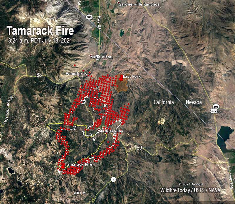
The Tamarack Fire in Northern California crossed Highway 89 Saturday, burning past Markleeville prompting additional evacuations of Woodfords and Alpine Village. The fire crossed the East Fork of the Carson River near the East Fork Resort and moved into lighter fuels which aided in the growth to the north and northeast during the afternoon hours, spreading approximately three to five miles in 24 hours.
Saturday at 5 p.m. the Incident Management Team reported that the fire had burned an estimated 21,000 acres, and that mandatory evacuations were in place for the following areas: Grover Hot Springs, Shay Creek, Marklee Village, Markleeville, Carson River Resort, Poor Boy Road area, Wolf Creek Campground, Silver Creek Campground, Sierra Pines, Upper and Lower Manzanita, Crystal Springs, Alpine Village, Diamond Valley Road and Hung-a-lel-ti.
Residents can sign up for evacuation notifications by clicking on a link at https://alpinecountyca.gov/204/Sheriff. However, we checked it at 8:50 a.m. Sunday and the site was down.
The number of reported structures destroyed remains at two. The fire continues to impact Markleeville and the surrounding areas. Firefighters are actively suppressing the fire where they can safely do so utilizing a variety of tactics and natural barriers.
In the photo below taken at 9:15 a.m. Sunday, the Tamarack Fire appears to already be creating pyrocumulus clouds. This is not common a few hours after sunrise.

The fire started from lightning on July 4. It was monitored for 13 days remaining at about a quarter of an acre, but not suppressed. It grew very large on July 16. Since then, the Humboldt-Toiyabe National Forest has attempted to suppress it, reporting zero containment on July 17.
The fire is in an area of California suffering from extreme drought and is being driven by very low fuel moistures, low humidity, and strong winds. It is burning in an area which, for the most part, has not been visited by fire for more than 30 years.

The temperature Saturday reached 85 degrees while the relative humidity was in the high teens. The wind in the morning at a weather station near Woodfords was fairly benign. But from 3 p.m. Saturday until 3 a.m. Sunday it increased, coming from the south-southwest at 3 to 13 mph with gusts of 10 to 25 mph. From 4 a.m. until 7 a.m. Sunday it was calm.
A Red Flag Warning is in effect for the area until Monday morning. But compared to Saturday, there will be less wind, slightly higher relative humidity, and some shading from clouds. The forecast for Sunday calls for 3 to 6 mph winds out of the southeast until 2 p.m., which will put additional pressure on Woodfords and the nearby Highway 88 corridor. After 2 p.m. the wind will be generally from the southwest all the way through Friday, unless affected by passing thunderstorms. Wind speeds of 6 to 10 mph are expected Sunday afternoon with a high of 85 degrees and 20 percent relative humidity. On Sunday and Monday it will be mostly cloudy in the afternoons with a chance of thundershowers.

Video credit: Craig Philpott via Storyful


