UPDATED 11:41 a.m. MDT, May 16, 2012
We will update the information and the maps of the fires in Arizona throughout the day on Wednesday. Check back for additional information, which is gathered from various sources, including the US Forest Service, Arizona state agencies, and the National Interagency Fire Center.

GLADIATOR FIRE
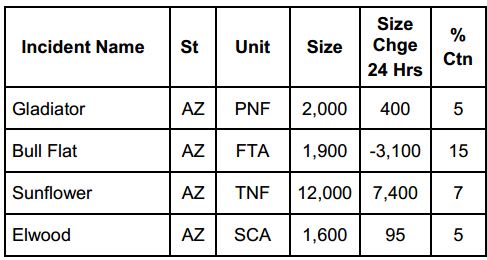
36 miles north of Phoenix, and 8 miles southwest of Mayer. It started as a structure fire in the community of Crown King.
Predicted drier weather and associated strong winds continue to complicate suppression efforts on the Gladiator Fire. Winds from the southeast and south are expected to push the fire north and northwest today.
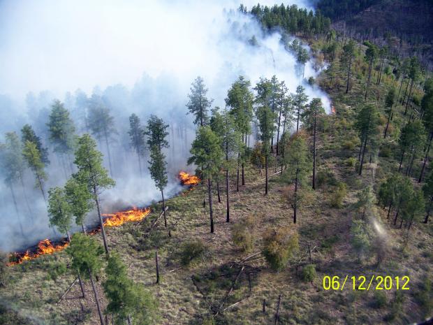
Fire behavior is expected to be extreme. Firefighters continue working to suppress the fire and provide structure protection to homes. Firefighting resources will focus on perimeter control when they can do so safely. Crews are also working to protect structures and communication sites west of the fire. In areas where direct attack is not feasible, they will focus on protecting individual structures ahead of the fire.
An evacuation order remains in effect for the community of Crown King.
A Type 1 Incident Management Team (Incident Commander, Joe Reinarz) assumed command of the fire Monday afternoon.

(Additional information and maps about other fires in Arizona is below.)
SUNFLOWER FIRE
The fire is located 1 mile west of Hwy 87 near Sunflower; 34 miles northeast of Phoenix; 19 miles southwest of Payson.
Strong winds, shifting from the east to the south greatly influenced the Sunflower Fire yesterday. As anticipated, the fire became very active during the afternoon with as the fire advanced to the north, northwest and west. Several dense pockets of fuel in the fire’s interior burned intensely resulting in three large plumes of smoke. In spite of this, the fire remained within established containment lines.
Actions taken by firefighters on the Sunflower Fire Monday significantly affected the results of suppression efforts Tuesday. When winds shifted Monday, blowing from the northeast, the decision was made to discontinue line preparation along Forest Road 201 and initiate firing operations, taking advantage of the wind to push the burn through the ground fuels into the interior of the fire. This created a wide black line along the perimeter. When the expected wind shift to a south wind occurred yesterday, the fire was prevented from reaching the road. Had these actions not been taken, there is a substantial possibility that the fire would have crossed the road, leaving firefighters no alternative but to move back to State Route 87. With no roads available between FR201 and SR 87, it would have been unsafe to place firefighters in between. The highway and the power lines would have been compromised.
Pushed by the same wind that helped with the black line operation on Monday, the fire moved rapidly to the southwest. It burned up to the seventeen year old fire scar of the Basin Fire and stopped at that point. This same influence may be expected when the Sunflower Fire reaches the scar of the eight year old Willow Fire. The thinner fuels in the fire scars reduces the fire intensity and slows the growth of the fire.
A Type 2 Incident Management Team, Incident Commander Clay Templin, is assigned to the fire.

BULL FLAT FIRE
20 miles northwest of Cibecue, AZ; South of Canyon Creek Fish Hatchery.
On Wednesday, crews will focus on extinguishing hot spots along the fire’s perimeter and construct containment line on the northeast corner of the fire in preparation for a burnout that will help to secure that portion of the line.
A Type 2 Incident Management Team (Incident Commander, John Philbin) is assigned to the fire.