


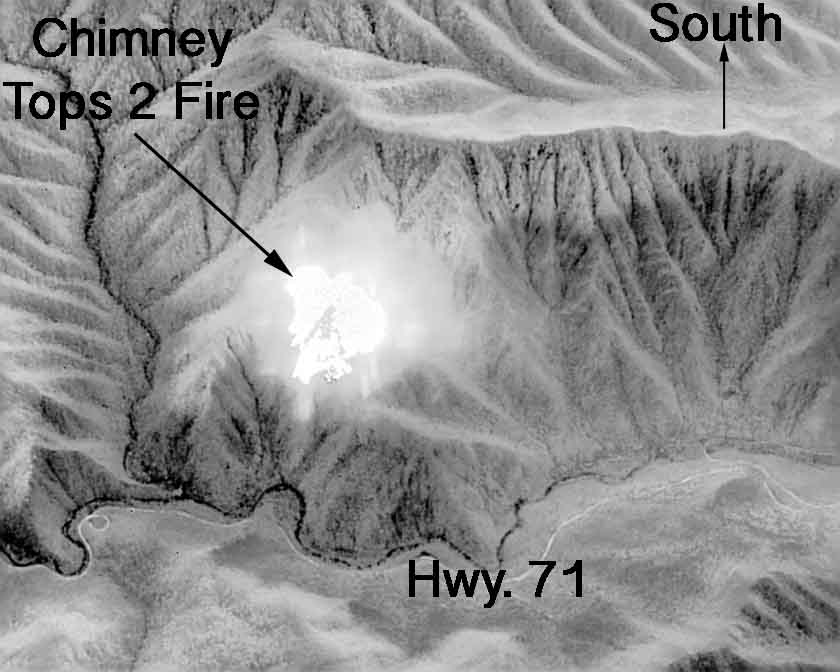
Above: Infrared map of the Chimney Tops 2 Fire, November 27, 2016. By Colorado’s MultiMission Aircraft.
For the most current information about the Chimney Tops 2 Fire at Gatlinburg, see our articles tagged “Chimney 2 Fire”.
(UPDATED at 11:05 p.m. EST November 29, 2016)
Sevier County officials reported that there have been three fatalities related to the fires in the Gatlinburg, Tennessee area. Sevier County includes Pigeon Forge, Gatlinburg, and part of the Great Smoky Mountains National Park. At least 14 people have been injured.
Three individuals with severe burns were transferred from the University of Tennessee’s Knoxville (UTK) Hospital to Vanderbilt Medical Center in Nashville Monday night. A fourth person with burns to their face continues to be evaluated at UTK.
Pigeon Forge officials estimate 500 people were evacuated on Monday night. Approximately 125 people remain displaced and in local shelters in Pigeon Forge. About 14,000 residents and visitors evacuated from Gatlinburg.
The National Park service estimates that a total of 15,000 acres have burned in Great Smoky Mountains National Park and in the areas in and around Gatlinburg and Pigeon Forge. On Wednesday the NPS will transfer command of the fires within the park to a Type 1 Incident Management Team run by Mike Dueitt. Teams like this are made up of federal and state interagency team members from across the country who collaboratively manage wildland fires and other natural disasters.
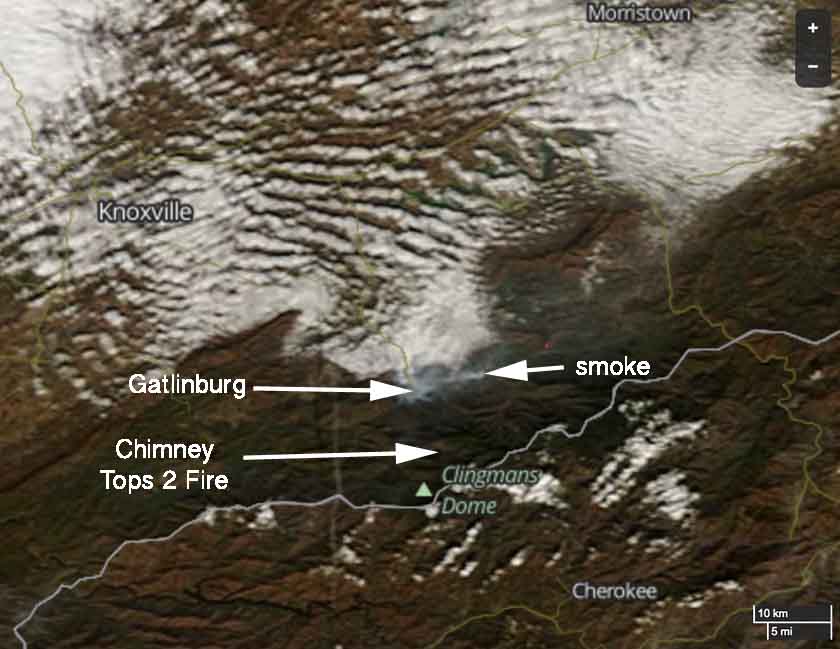
Eventually we hope to obtain a map, much better than the one above, of the fires in the Gatlinburg area. Check back later. (UPDATE: we posted a much better map on November 30.)
We do not yet have complete information about how many fires are burning, where they are, the causes, and where all of the fire(s) started that eventually burned into the communities of Gatlinburg and Pigeon Forge.
The NPS reported Tuesday morning that 80 mph winds gusts, low humidities, and drought conditions…
…caused the fire burning in the National Park to spread rapidly and unpredictably, in spite of suppression efforts on Sunday that included helicopter water drops. Wind gusts carried burning embers long distances causing new spot fires to ignite across the north-central area of the park and into Gatlinburg. In addition, high winds caused numerous trees to fall throughout the evening on Monday bringing down power lines across the area that ignited additional new fires that spread rapidly due to sustained winds of over 40 mph.
Presumably the fire within the park was the Chimney Tops 2 Fire, which started November 23 and was reported to be 10 acres Sunday evening, November 27. Apparently the NPS was not able to completely suppress the fire during that four-day period.
The Tennessee Emergency Management Agency, in their Tuesday update, wrote:
The Chimney Top Fire, which began in the Great Smoky Mountains, spread very rapidly yesterday evening as high winds pushed flames onto private property.
They were probably referring to the Chimney Tops 2 Fire.
****
(UPDATED at 10:13 a.m. EST November 29, 2016)
About 100 homes in Seiver County Tennessee have been either damaged or destroyed in wildfires that started in or near Great Smoky Mountains National Park in eastern Tennessee. The state’s Emergency Management Agency (TEMA) which conducted a quick preliminary survey, reported at 3 a.m. ET Tuesday that about 10 of those homes were in Gatlinburg. In addition, 30 other structures in Gatlinburg have been damaged or destroyed, including a 16-story hotel on Regan Drive and the Driftwood Apartments near the Park Vista Hotel.
State Highway 441 heading into Gatlinburg is closed, except for emergency traffic but it is open for evacuating residents.
There are no reports of fatalities. TEMA reports that three persons with severe burns were transferred form University of Tennessee’s Knoxville (UTK) hospital to Vanderbilt Medical Center in Nashville overnight. A fourth with burns to their face continues to be evaluated at UTK. Currently, there are no reports of fatalities.
An accident involving a fire truck resulted in minor injuries.
Over 12,000 residents are without power and 1,200 are being sheltered at the Gatlinburg Community Center and the Rocky Top Sports Park.
From Great Smoky Mountains National Park Tuesday morning:
Unpredicted, extreme weather conditions on Sunday afternoon through Monday led to the exponential spread of fires both inside and outside of the National Park. Severe wind gusts of over 80 mph, unprecedented low relative humidity, and extended drought conditions caused the fire burning in the National Park to spread rapidly and unpredictably, in spite of suppression efforts on Sunday that included helicopter water drops. Wind gusts carried burning embers long distances causing new spot fires to ignite across the north-central area of the park and into Gatlinburg. In addition, high winds caused numerous trees to fall throughout the evening on Monday bringing down power lines across the area that ignited additional new fires that spread rapidly due to sustained winds of over 40 mph.
The Tennessee National Guard is in the process of mobilizing 100 personnel from East Tennessee to assist Sevier County with transporting 1st responders, removing light debris, and assisting with welfare checks.

At least 50 to 60 engines from fire departments in east Tennessee have responded to assist.
Great Smoky Mountains National Park officials have closed all facilities in the park due to the extensive fire activity and downed trees.
The video below shows multiple structures burning in Westgate Resort.
WATCH: Incredible video from @wbir viewer Aaron Gholston of flames completely taking over Westgate Resort in #Gatlinburg pic.twitter.com/w4M0GNmNiv
— Madison Wade (@madisonwadeWBIR) November 29, 2016
****
(UPDATED at 12:25 a.m. EST November 29, 2016)

****
(UPDATED at 12:09 a.m. EST November 29, 2016)
Pigeon Forge, north of Gatlinburg, is being evacuated. This notice was sent at 11:47 p.m. EST November 28:

About a tenth of an inch of precipitation has fallen in the last hour at several weather stations in the Gatlinburg and Great Smoky Mountains area. But that wave of rain was short-lived, and Brad Panovich (@wxbrad) reports that it only briefly slowed the spread of the fires. But more is on the way.
The video below was shot from inside the Park Vista Hotel in Gatlinburg, TN.
****
(UPDATED at 10:48 p.m. EST November 28, 2016)
The voluntary evacuation for Gatlinburg has escalated to an urgent evacuation of the entire city.
The Sevier County Emergency Management Agency sent the following message via the National Weather Service Monday night:
Urgent – immediate broadcast requested
Evacuation Immediate
Sevier County emergency management Agency
Relayed by National Weather Service Morristown TN
903 PM EST Mon Nov 28 2016The following message is transmitted at the request of the Sevier County emergency management Agency.
The city of Gatlinburg and nearby communities are being evacuated Due to wildfires. Nobody is allowed into the city at this Time. If you are currently in Gatlinburg and are Able to evacuate…Evacuate immediately and follow any instructions from emergency officials. If you are not instructed to evacuate…Please Stay off The Roads.
****
(Updated at 8:30 p.m. EST November 28, 2016)

At least two wildfires burning in Great Smoky Mountains National Park are causing problems in the park and in nearby Gatlinburg, Tennessee. The Chimney 2 Fire has been burning since November 23 and was reported to be 10 acres Sunday evening, but overnight 40 mph winds gusting to 74 mph caused the fire to spread more quickly. Park officials on Monday morning estimated it had grown to about 500 acres.
A second fire was discovered Monday near the Twin Creek Picnic Pavilion off Cherokee Orchard Road two miles south of Gatlinburg.

Officials have ordered the evacuation of the Twin Creeks area, as well as the Elkmont and Park Headquarters housing areas.
An incident management team and four 20-person hand crews should be arriving Monday and Tuesday.
These fires are sending large quantities of smoke into nearby Gatlinburg, Tennessee. According to WJHL, on Wednesday afternoon the Gatlinburg Fire Department was going door to door asking residents to voluntarily evacuate.
The weather forecast for Gatlinburg calls for very strong winds, 25 mph gusting to 41 mph, to continue Monday night, but there is an 80 to 100 percent chance of rain during the night, possibly as much as 0.8 inch. The rain is expected to continue through Wednesday night. If the National Weather Service forecast is correct, Gatlinburg could receive over 2 inches of rain during this 48-hour period. If it does not put out the fires in Great Smoky Mountains National Park, it will certainly slow them down for an extended period of time.
For the most current information about the Chimney Tops 2 Fire at Gatlinburg, see our articles tagged “Chimney 2 Fire”.


