


Above: Wildfire preparedness, according to StatesAtRisk.org
Two organizations have collaborated to develop what they call America’s Preparedness Report Card (StatesAtRisk.org), laying out their scores for how America’s 50 states are preparing for a changing climate. They came up with ratings in five categories:
- Extreme Heat
- Drought
- Wildfires
- Inland Flooding
- Coastal Flooding
According to their web site, ClimateCentral.org, one of the two organizations, is “An independent organization of leading scientists and journalists researching and reporting the facts about our changing climate and its impact on the public.” The other, ICF International, is a private company that appears to offer a very broad range of consulting services.
We were most interested in their analysis of wildfire issues. The states colored gray on the map above are labeled “n/a”, which means wildfire was not identified as a threat. The methodology used was to determine the average number of days each year when the Keetch-Byram Drought Index exceeded 600. This was weighted by the county-level population living in the wildland-urban interface (WUI). They did not take into account fire history, the number of homes destroyed by fire, or vegetation.
We noticed, for example, that wildfire was not identified as a threat in Colorado in spite of the fact that in 2012, the Waldo Canyon Fire burned more than 18,000 acres, destroyed 347 homes in Colorado Springs and killed two people. Almost exactly a year later, the Black Forest Fire ignited east of the city and burned more than 15,000 acres, 486 homes and killed two people.
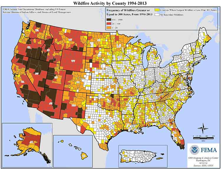
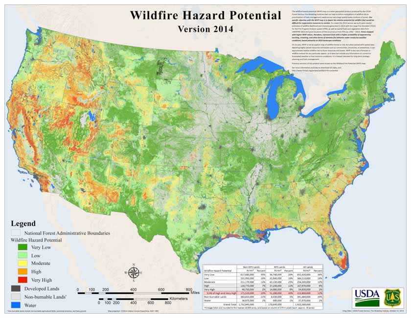
Their map is different from the ones below created by the U.S. Forest Service (showing the frequency of wildfires greater than 299 acres from 1994 to 2013) and FEMA’s map of wildfire hazard potential.
In looking at two other states, Alabama was given an “F” in wildfire preparedness while California earned an “A”.
The list of factors that were considered in determining the grades included:
- Current wildfire vulnerability assessments and hazard mitigation and emergency response plans;
- Guidelines or requirements for resilient activities (e.g., construction);
- Wildfire adaptation policy or guidelines;
- Communication with residents about mitigating for wildfire.
Below are graphical wildfire preparedness summaries from StatesAtRisk.org for Alabama and California:







