A wind-driven wildfire ignited late Thursday night outside the Alaskan village of Chiniak, on Kodiak Island off the coast from Anchorage.
Village residents began evacuating around 11 p.m. on Thursday, and by early Friday morning local police were urged those remaining to leave as the fire spread, according to reports by the Alaska Dispatch News.
By Friday morning, crews estimated that the fire had burned 2,000 acres. A handful of homes and the local library were destroyed; reports did not say how many homes were burned.
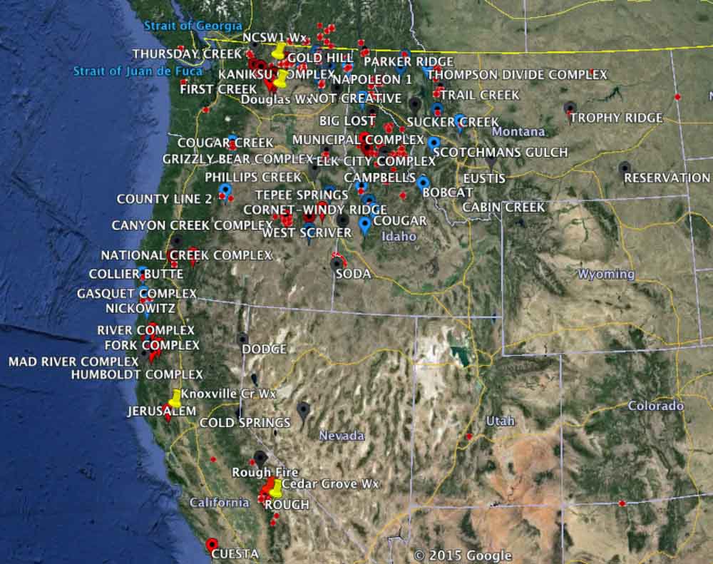
Map, large uncontained wildfires in the West, August 19, 2015.
This update from Pacific Southwest Regional Forester Randy Moore was circulated this week. The report covers the fire siege update for the U.S. Forest Service’s Region 5.
****
The personnel working our fires are making significant progress towards containment. Although clear skies did increase fire behavior good progress continues with resources on hand.
Up north the Mad River Complex is on top of our priority list. The complex is being managed by the Northern Rockies IMT1 (Turman). The team is also managing the Route Complex.
Both complexes are experiencing active burning throughout the night with single tree and group tree torching. Containment percentages on both complexes are rising and hopefully this incoming weather will help increase those numbers.
If everything goes as planned we will be demobilizing Area Command over the weekend. All indications are that the Area Command Team was an asset and benefit to the Shasta-Trinity and Six Rivers. The coordination between the Forest Agency Administrators, Fire Staff, the Coordination Center, and the Area Command Team worked very well and provided clarity for roles and responsibilities during large incidents.
In South Ops the Rough Fire is our top priority. CA Type 2 IMT (Cooper) remains in command of the North Zone of the fire and CA Type 1 IMT 3 (Vontillow) remains in command of the South Zone of the fire. Unfortunately Hwy 180 remains closed to through traffic and all forest closures remain in place.
In the South Zone, efforts in the Ten Mile drainage have significantly reduced the structure threat to commercial and residential structures in the Hume Lake area. Critical line construction is near completion from Hwy 180 to the Kings River. The fire does continue to spread east and into the Boulder Creek drainage. In the North Zone, the corner of the fire at the confluence of the Middle and North Forks of the Kings River has been secured. The fire reached the river mid-morning Wednesday.
This fire is receiving a lot of attention from many interested individuals and groups. I think it’s important to remember that all fires on NFS lands in California have protection objectives, and none are being ‘managed’ specifically for additional resource benefit Forest Plan objectives. Safety and fiscal risks relative to strategies and tactics with low probabilities of success are not being pursued: all fires have suppression strategies, including the Cabin Fire on the Sequoia NF which is using a ‘confinement’ suppression strategy. The Rough Fire on the Sierra NF, and now on the Sequoia NF, from its inception has had a suppression strategy, as have all fires on the Shasta Trinity and Six Rivers National Forests.
We have been quite successful in implementing salvage efforts for the past few years. We have completed the NEPA process for several large projects in less than a year and although litigated we have prevailed in both District Court and the 9th Circuit Court of Appeals. With the experience we gained, the region has worked to develop a streamline approach to request and get approvals for Emergency Situations Determinations from the Chief. We have received approval from the Chief on 100% of all ESDs (possibly Ecological Site Descriptions) requested in the last three years, which effectively shortens the time from planning to project advertisement.
In addition we have been successful with requesting and obtaining approvals from the Council of Environmental Quality for alternative arrangements. As a region, over the past 2 years, alternative arrangements have been granted by CEQ for the Rim Fire (Stanislaus) and King Fire (El Dorado NF).
With this emphasis on fire salvage, we do have some challenges that we are working to overcome. One item that has been an issue is industry capacity, especially due to the amount of salvage available from private land. Another issue has been capacity of personnel; currently we have most of our resource specialists serving as resource advisors or they are on Burned Area Emergency Rehabilitation Teams. This other priority work for our specialists does have an effect on our startup time for the salvage analysis efforts.
Although, these challenges exist, the region will continue to emphasize salvage as this tool is vital to making our communities, roads, administrative sites and trails safe for our publics. However important, we must balance salvage, reforestation and proactive forest restoration treatments in order to recover resilient forests. To achieve timely and legally defensible projects, we will use all the tools (ESDs, Alternative Arrangement, and Categorical Exclusions) to restore our nation’s forest. Your voice and written support for these salvage efforts will strengthen the rationale and importance of these projects.
As I close I want to mention that many of the out of state resources that came to help us have been returned to their home units to supplement thinly stretched firefighters in their local unit suppression efforts. We really can’t say “thank you” enough to all those who responded during our time of critical need. I am sure we will be returning the favor down the road. I am also sure we can all remember what it felt like to be working on a fire and knowing that your town back home was threatened. It shows some real professionalism and grace to keep working while you’d rather be back home.
As might be expected all of the complexes have postponed repair work for now. The R5 GACC’s have made resources typically held for repair work available for reassignment in the other geographic areas with critical needs. When fire activity has calmed we will get the crews back for repair work and I am anticipating we will be hosting them for some time.
The National Weather Service has issued Red Flag Warnings or Fire Weather Watches for areas in California, Washington, Nevada, Wyoming, Idaho and Montana.
The map was current as of 9 a.m. MDT on Friday. Red Flag Warnings can change throughout the day as the National Weather Service offices around the country update and revise their forecasts and maps. For the most current data visit this NWS site or this NWS site.
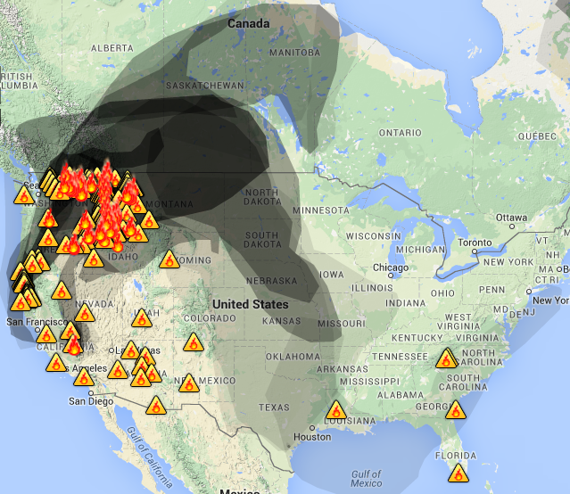
Heavy smoke from northwestern fires continues to drift into Canada, although as of Friday morning, the smoke was less severe than it had been in previous days.
Smoke Map, Aug. 28, 2015. AIRNow.gov
To see the most current smoke reports on Wildfire Today, visit the articles tagged “smoke” at https://wildfiretoday.com/tag/smoke/
Anticipating a budget shortfall, the U.S. Forest Service has begun transferring money from its various branches to fuel its dwindling fire suppression fund.
This summer, the agency announced that for the first time in its 110-year history, it will spend more than 50 percent of its budget on fire suppression, a figure that has shot up from around 16 percent in the mid-1990s.
The first withdrawals from programs were set to begin this week, according to an internal memo sent to Forest Service employees from Chief Tom Tidwell. The memo, sent on Aug. 25, said that the agency has only $174 million left in its budget for fighting wildfires, of $1.01 billion that was set aside.
The Forest Service will transfer the funds in two increments, the first of $250 million this week and the second of $200 million at a later date.
“The Washington Office budget staff will work directly with your budget staffs to collect information on significant impacts these transfers will have on your units,” Tidwell said in the letter.
Historically, fire prevention programs have suffered due to the fire transfer, also known as fire borrowing. In 2014, the Forest Service released a state-by-state study showing the impacts of the transfer on various land management projects throughout the country.
“The multitude of benefits that forests provide to the public—including clean air and water, recreation, forest products, and jobs—are at risk because of the broken federal wildfire funding system,” said Florida State Forester Jim Karels in a statement on Friday. Karels is president of the National Association of State Foresters.
“It’s too late for Congress to act to prevent transfers this fire season. But Congress must act soon to ensure this is the last time we rob resources to fund fire suppression at the expense of our nation’s forests’ long-term health.”
The National Weather Service has issued Red Flag Warnings or Fire Weather Watches for areas in Washington and Montana.
The map was current as of 9 a.m. MDT on Thursday. Red Flag Warnings can change throughout the day as the National Weather Service offices around the country update and revise their forecasts and maps. For the most current data visit this NWS site or this NWS site.
Smoke map, Aug. 27 2015. AIRNow.gov.
Heavy smoke from northwestern wildfires is continuing to blanket southern Canada. Unhealthy levels of smoke have been forecasted for central and western Canada, in Alberta and British Columbia, as well as northern Washington, Idaho and Montana.
Air Quality map, Aug. 27, 2015, AIRNow.gov
To see the most current smoke reports on Wildfire Today, visit the articles tagged “smoke” at https://wildfiretoday.com/tag/smoke/
Kenji Kato has been posting daily Google Earth flyover updates on the Washington wildfires on his youtube.com channel. It’s a long video but worth the trip — using data from the U.S. Forest Service, Kato’s video looks at fire perimeters, hot spots, evacuation zones and homes burned among the series of large fires in Washington.
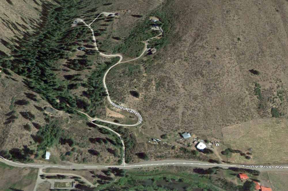
The general area of the fatalities. They were found 40 feet off Woods Canyon Road. The 3-D map is looking north.
Three firefighters who were killed on Aug. 19 will be honored in a memorial service in Wenatchee, Washington on Sunday, Aug. 30.
Firefighters Tom Zbyszewski, 20, Richard Wheeler, 31, and Andrew Zajac, 26, died last week when their apparatus crashed as they were trying to escape a fire near Twisp, Washington. One firefighter, Daniel Lyon, 25, of Puyallup, Washington, is in critical condition with third degree burns over over 60 to 65 percent of his body.
Since their deaths, at least six investigations of the incident have been launched. On Aug. 23, the U.S. Forest Service released more information about the deaths of the three firefighters. Read that post here.
The service for the firefighters will begin at 1 p.m. at the Town Toyota Center in Wenatchee.
A group of horses pay no attention to a firing operation going on behind them on Division X of the Okanogan Complex August 25, 2015. Firefighters were using drip torches and incendiary devices (sausages) shot from a verry pistol to burn out the hillside to the west of Spring Coulee Road in Okanogan, WA connecting areas to the north and south that had previously burned to protect homes in the area.
Here is his dispatch from the Hopps Helibase on Aug. 25, 2015.
****
Walker’s Area Command, based in Colville, WA, in August of the 2015 fire season, has setup a large helibase on farmland south of town. The property is owned by the Hopps family, thus giving the base it’s name. The facility allows both civilian contract helicopters a base and a location for military ships to stage until needed on the numerous fires in the area.
At Hopps this morning; August 25th, were a pair of Bell 205 A1++, two AStar A350s, one Bell 206 L4 as well as one of Columbia Helicopters Boeing Vertols joined by a couple of Blackhawks and a Chinook flying in from their overnight base at Fairchild A.F.B outside of Spokane.
The Federal Aviation Administration is operating a temporary tower at the helibase since up to 20 helicopters are anticipated to be using the base as the fire season continues in northeast Washington.
With the FAA control tower in the background and a Bell 205 A1 ++ in the foreground, a Bell 206 L4 carrying members of Swan Valley Helitack from the Caribou-Targhee National Forest, take off for a mission on the Carpenter Road Fire. Members of Swan Valley Helitack from the Caribou-Targhee National Forest prepare for a mission to the Carpenter Road Fire near Colville, WA August 25, 2015. An Army Chinook lumbers overhead on final approach for a landing at the Hopps Helibase over a Columbia Helicopters Boeing Vertol.
Smoke map, Aug. 26. 2015. Source: wunderground.com
Areas of Washington, Idaho, Oregon and Montana are in the center of the worst smoke being generated by local fires, as of 8:45 a.m. MDT. Air quality forecasts show unhealthy levels of smoke in all four states, with unhealthy advisories extending into Canada.
Air quality advisories, Aug. 26, 2015. AIRNow.gov
As of 8:45 a.m. MDT, there were no Red Flag Warnings. These warnings can change throughout the day as the National Weather Service offices around the country update and revise their forecasts and maps. For the most current data visit this NWS site or this NWS site.
UPDATE:
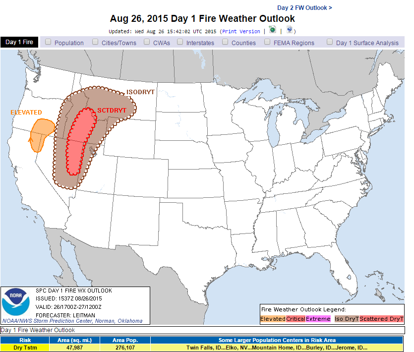
While there were no Red Flag Warnings issued as of 12:40 p.m. MDT, fire weather forecasts show elevated risk for southeastern Oregon and northeastern California. A second-day forecast showed critical fire weather risk spreading into Idaho and Montana.
Fire Weather Outlook, Day 1, noaa.gov Fire Weather Outlook, Day 2, noaa.gov
To see the most current smoke reports on Wildfire Today, visit the articles tagged “smoke” at https://wildfiretoday.com/tag/smoke/
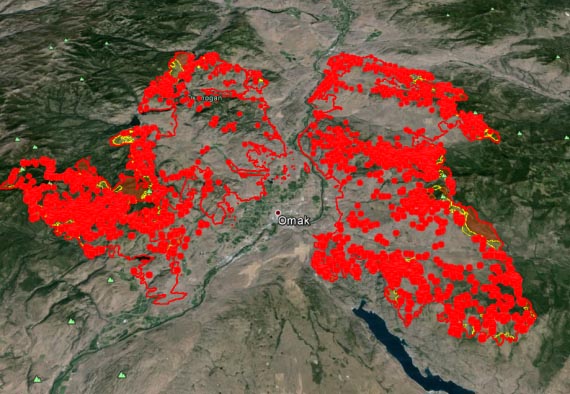
Okanogan Complex. Fire perimeter as of Aug. 24, 2015.
The Okanogan complex fires have grown into the largest wildfire in Washington history at more than 256,567 acres, surpassing last year’s record-setting Carlton complex fires, which burned 256,108 acres.
The complex is now made up of what were five fires — the Twisp River fire, the Lime Belt fire, the Beaver Lake fire, the Blue Lake fire and the Tunk Block fire. The Lime Belt, Beaver Lake and Blue Lake fires have merged, according to the latest perimeter information from the U.S. Forest Service.
The two main branches of the fire — the merged Lime Belt fires and the Tunk Block fire — have burned more than 100,000 acres each.
The latest perimeter maps for the complex, taken from infrared data on Aug. 24, do not include the Twisp fire.
As of Aug. 24, more than 500 utility customers remain without power in Okanogan County, since the fire complex has destroyed more than 500 utility poles, according to the Okanogan County Public Utility District. It will take a week to restore power to some areas, while it could take a few weeks to restore power to others.
The Chelan complex fires (see below) also continued to rage south of the Okanogan complex. Infrared flights on Aug. 24 showed that the fire had grown 509 acres, expanding the fire perimeter to 87,830 acres.
Overall, the fire’s heat has dropped, particularly in the perimeter’s southern and eastern quadrants (highlighted blue area on the map). These quadrants were not scanned by IR flights on Aug. 24, since there has been little heat in those areas for several nights, according to flight information.
Chelan complex fire perimeter as of Aug. 24, 2015.