(UPDATE at 9:25 a.m. MT, June 18, 2013)
The video below was shot by KKTV chief photojournalist Mike Petkash. It was posted Tuesday morning, June 18.
An update from the El Paso County Sheriff’s office lists 502 primary residences that were destroyed in the Black Forest Fire and another 18 with partial damage.
American Red Cross Disaster Assistance Teams are doing assessments within the fire perimeter. Utility crews continue assessing and securing service to residences for future re-entry. Excess resources are being released as incident objectives are being met. Firefighters continue to mop up and secure around structures to prevent further loss.
****
(UPDATE at 11:47 a.m. MT, June 17, 2013)
A tweet from KKTV in Colorado Springs:
That is the first time I have heard of this happening — survivors from a massive, very destructive wildfire less than a year before hold a picnic for survivors of another even more destructive wildfire that occurred just a few miles away.
Thunderstorms on Sunday brought 0.11 inches of precipitation to the Black Forest Fire area, which aided firefighters in their mop up efforts. The storm also produced lightning that ignited three new fires in the burn area which were quickly suppressed by firefighters, according to Incident Commander Rich Harvey.
The size of the fire has been more accurately determined to be 14,280 acres; on Saturday it had been listed at 15,500 acres. The cost of fire suppression is estimated at $5.5 million and 4,100 people are still under mandatory evacuation orders. The Denver Post has a map showing evacuation areas and the locations of structures that have burned.
Firefighters are placing flagging at residences, and writing on it the the date, time, and the name of the crew that checked and mopped up the area.
Incident Commander Rich Harvey told CNN on Sunday, June 16:
The perimeter work is done, now we’re focused on coming interior and making sure that all the heat that could eventually create sparks that could get over our line are done — we call it mop up.
At an 11:15 a.m. MT briefing on Monday, IC Harvey said the fire is 75 percent contained. (More information about “containment”.)
A Monday morning news release from the IMTeam detailed some of their plans for the day:
A continuing threat exists to structures within the fire perimeter due to the potential for extreme fire behavior from gusty winds from developing thunderstorms. The potential for re-burn from remaining hot spots within the ground fuels remains a concern. Firefighters will continue to grid the fire area for hotspots, especially around structures.
A media tour scheduled for Monday morning during which members of the press were going to be transported around the fire in a bus was postponed and no new date was established.
****
(UPDATE at 9:50 a.m. MT, June 16, 2013)
Photos we took at the fire June 14 and 15 can be found HERE.
Colorado 83 is now open in both directions from Powers Boulevard to Walker Road. The County has published a map of the fire.
When we were in the burned area on the south part of the fire Saturday, it was evident that firefighters had done an excellent job of mopping up. In the portions of the fire we saw, only a few areas producing smoke could be seen.
****
(UPDATE at 7:40 p.m. MT, June 15 2013)
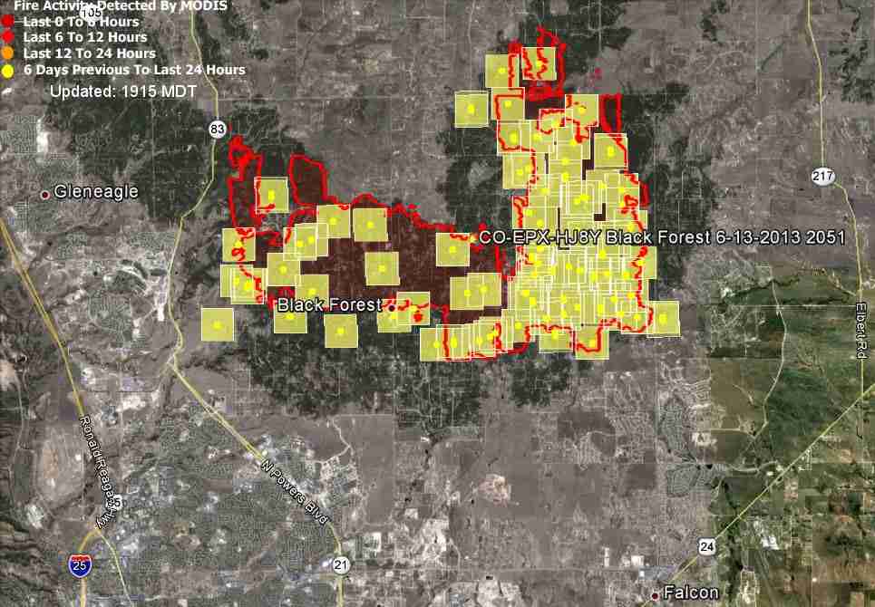
The map above shows the approximate location of heat detected by a satellite on the Black Forest Fire. The squares can be a mile in error. The satellite was not able to detect any major heat sources within the 24 hours prior to the flyover at 2:13 p.m. today. Small concentrations of heat can’t be detected by the satellite as it passes over about 200 miles above the Earth. The red line is the last fire perimeter that was released by the Incident Management Team, on June 13
At a press briefing Saturday evening, County Sheriff Terry Maketa said evacuations have been lifted for some areas and Colorado 83 would re-open in both directions Saturday night.. The Incident Management Team said the control containment has increased to 55 percent.
The number of structures destroyed has also increased, to 483. There was no breakdown this time of homes vs. other structures. The previous update was 473 structures, with 419 being homes.
****
(UPDATE at 8:40 a.m. MT, June 15, 2013)

While cooler weather and even a little rain helped firefighters make progress on the Black Forest Fire Friday, the reported number of structures destroyed has increased to 473. Of those, 419 are homes. An additional 17 structures had partial damage. The official list of affected structures is at the El Paso Sheriff’s web site.
The size of the fire remains about the same, at 15,700 acres, but the Incident Commander said the containment has increased from 5 to 30 percent.
All evacuations for the city of Colorado Springs have been lifted, however other areas are still under evacuation orders. The El Paso County web site has more details.


Later today we will post more information and hopefully some photos from the fireline.
****
(UPDATE at 9:20 a.m. MT, June 14, 2013)
At a 9:10 a.m. press briefing today the Sheriff led off by asking people to wash their cars — so that it would rain. The Sheriff and Incident Commander Rich Harvey were optimistic overall, after a night that had less fire activity than in previous days. No additional structures burned yesterday. The northern side of the fire is looking much better. There are still about 38,000 people impacted by the fire due to evacuations.
The fire is listed at 15,702 acres and the containment percentage remains at five. The Sheriff’s Department reports that 384 homes have burned. Approximately 800 personnel are working on the fire.
The major focus today will be on the west side, and there is still some work left to do on the east side.
****
(UPDATE at 5:55 p.m. MT, June 13, 2013)
In a briefing at 5 p.m today Sheriff Terry Maketa said the remains of two people were found. They had been talking on the phone with friends not long before they were entrapped, saying they were packing belonging in their vehicle and were preparing to evacuate. The friends could hear fire crackling in the background. The remains were found in a garage near their car. The garage door and the car doors were open.
The fire has burned 15,700 acres (24 square miles) and is 5 percent contained. Approximately 38,000 people have evacuated from 13,000 homes.
The incoming Incident Commander from the Great Basin Type 1 Incident Management Team #2, Rich Harvey, said 750 personnel are working on the fire. He praised the help being provided by local fire protection districts that are supplying local knowledge.
Higher humidity today moderated the fire behavior and it did not grow as much as in past days.
The Sheriff is not aware of any additional homes that were lost today.
The DC-10 (Tanker 911) and Minden’s P2V (Tanker 48) were seen dropping on the fire in the afternoon.

****
(UPDATE at 9:41 a.m. MT, June 13, 2013)
In this morning’s briefing by El Paso County Sheriff Terry Maketa that just concluded, the following information emerged:
- 360 homes have burned and are considered a total loss, 14 are partially damaged, 79 homes could not be accessed and their status is unknown, and 1,200 are unaffected. A list of the homes has been provided by the Sheriff’s office. (347 homes burned in the 2012 Waldo Canyon fire in Colorado Springs)
- 15,000 acres (23 square miles) have burned. They are making no estimate of containment. The acreage figure provided yesterday afternoon was 8,500.
- 38,000 people have been evacuated from 13,000 homes, covering 94,000 acres.
- The fire is revisiting and reburning some areas
- One person has been reported as missing, There have been no reports of serious injuries or fatalities. (UPDATE at 1:55 MT: the Denver Post reports the missing person has been found.)
- In spite of the fact that pre-evacuation and voluntary evacuation areas border Interstate 25 (map), the highway is not closed.
- No one from the Type 1 Incident Management Team that assumed command of the fire at 6 a.m. today spoke at the briefing this morning.
****
(UPDATE at 9:07 a.m. MT, June 13, 2013)
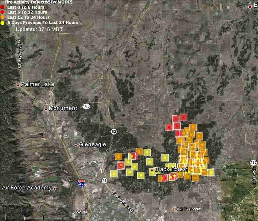
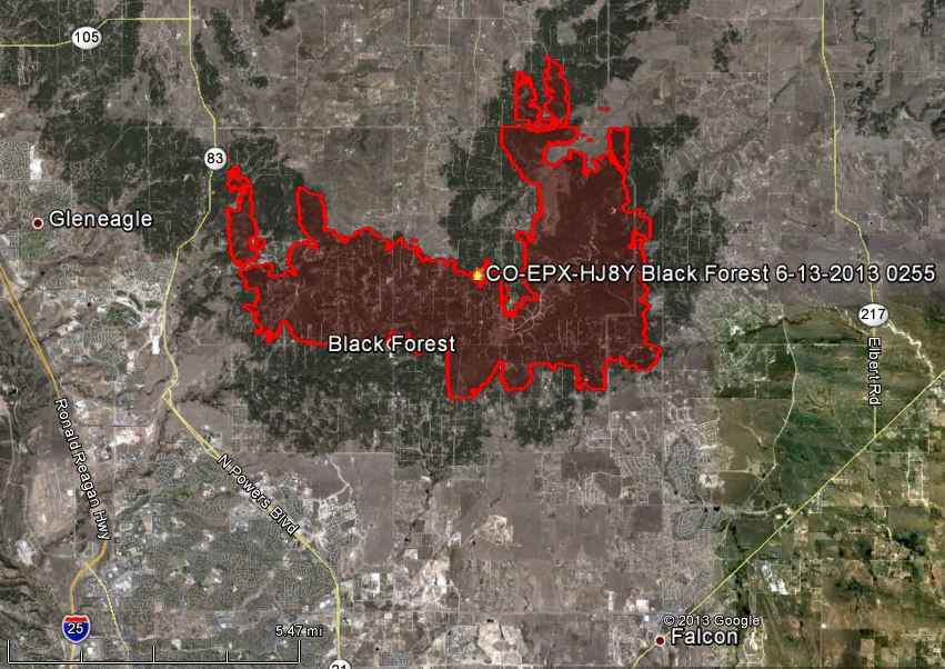
The map of the Black Forest Fire above shows the approximate location of heat detected by a satellite at 11:06 p.m. MT, June 12, 2013. The locations are not exact and can be off as much as a mile or so. The red squares were the most recently burned.
On Wednesday the fire continued to spread on the northeast side.
Overnight the evacuation area expanded and law enforcement officials went door-to-door notifying residents they had to leave. The evacuation area designations are changing many times a day, producing an even more confusing environment for local residents. The KKTV Facebook page is doing a good job of displaying the ever-changing maps of the areas under evacuation notices.
The El Paso County Sheriff has posted the status of homes in the fire area.
Something has to change for firefighters to be successful — either the weather or the fuels (vegetation). The fire is following the concentrations of pine trees. Where the fuel thins or changes to a lighter form of vegetation that is easier for firefighters to deal with, such as grass or brush, they stand a better chance of stopping the fire.

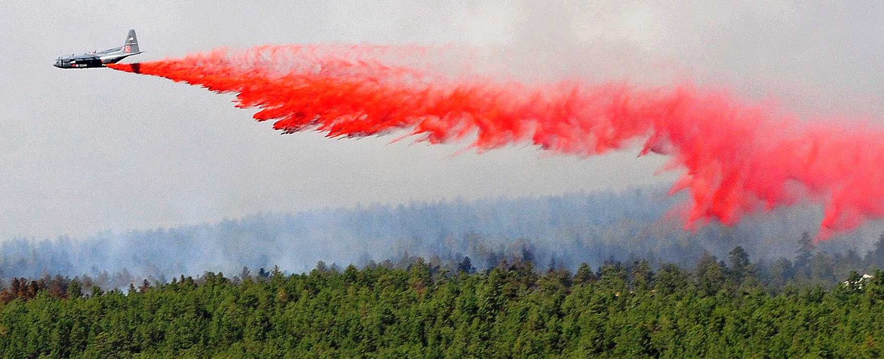
More firefighters arrived to fight the fire Wednesday and they were assisted by aerial resources, including about half a dozen military helicopters (photos), Korean War vintage P2V air tankers that carry about 2,000 gallons of retardant, and one of the DC-10 Very Large Air Tankers that holds 11,600 gallons. They were joined by two Modular Airborne FireFighting Systems (MAFFS) C-130 air tankers from the nearby Peterson Air Force Base which have a maximum capacity of 3,000 gallons — less at high altitudes or in hot weather.
The Black Forest Fire area is affected by a Red Flag Warning today from 11 a.m. until 7 p.m. Firefighters can expect south winds of 10 to 20 mph gusting up to 35 mph, relative humidity as low as 11 percent, and isolated thunderstorms after 2 p.m. producing lightning and even stronger winds. These conditions will be conducive to additional fire spread to the north.
Rich Harvey’s Type 1 Incident Management Team from the Great Basin Geographic Area was scheduled to assume command of the fire today at 6 a.m. This team also managed the Waldo Canyon Fire that burned into Colorado Springs in 2012.
FOX31 in Denver has some interesting photos of the fire, including one of a firefighter holding a deer, a fawn, that he rescued.
****
(UPDATE at 5:30 p.m. MT, June 12, 2013)
A news conference just concluded, in which the following information emerged:
- 92 homes have been destroyed in the fire and five have been damaged; 315 homes in the area are not affected. [KVDR has posted the list on their web site]
- Approximately 8,500 acres have burned. Potentially another 3,000 could burn. It is zero percent contained.
- Rich Harvey’s Type 1 Incident Management Team from the Great Basin Geographic Area is on site and will have their in-briefing today at 6 p.m. They will assume command of the fire Thursday at 6 a.m. This is the same team that managed last year’s Waldo Canyon fire that burned into Colorado Springs destroying 347 homes.
- Earlier today the fire moved toward the northwest, but in recent hours has been moving to the northeast, due to a shift in the wind direction.
- Approximately 9,00 to 9,500 residents are affected by the evacuation and pre-evacuation.
- 487 fire personnel from 28 fire districts, and 412 law enforcement personnel are working on the fire.
In watching the streaming live video this afternoon from KKTV, and seeing house after house burn, we have seen no crown fires moving through the tops of the trees. The fire is confined to the ground, moving at moderate speed across the forest floor beneath the pine trees. It appears that the houses would have had a much better chance of survival if they had been prepared to minimize their risk.
****
(UPDATE at 4:58 p.m. MT, June 12, 2013)
KKTV reports they were just given a list of 92 homes that are total losses, burned in the fire. KVDR has posted the list on their web site.
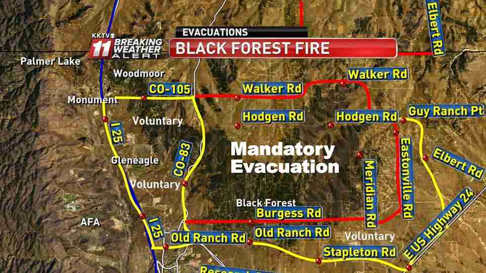
KKTV compiled the current evacuation information about the Black Forest Fire into the map below. The mandatory and voluntary evacuation areas continue to expand.
The house below is one that was consumed by the fire Wednesday afternoon.

The weather at the nearby WE1A weather station recorded at 4:35 p.m., 84 degrees, 15 percent relative humidity, and south-southeast winds of 9 mph gusting to 20 mph
****
(UPDATE at 3:09 p.m. MT, June 12, 2013)

****
(UPDATE at 2.42 p.m. MT, June 12, 2013)
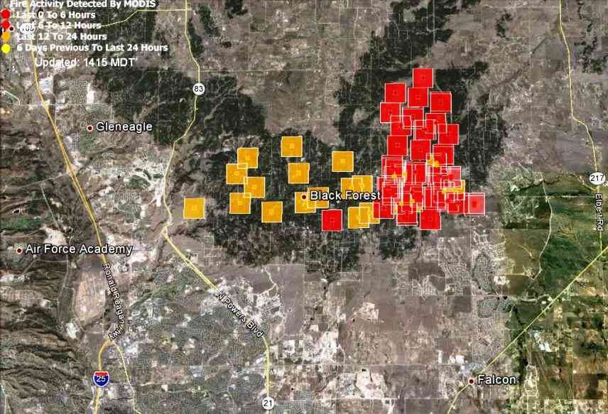
The above map contains new data on the location of the Black Forest Fire. It shows the approximate location of heat detected by a satellite collected at 12:01 p.m. MT today. The locations of the squares can be as much as a mile in error. The data indicates that the east side of the fire moved quite a bit to the north, pushed by the winds out of the south.
****

(UPDATE at 2:22 p.m. MT, June 12, 2013)
The New Life Church which had been used to shelter evacuees, has been evacuated due to heavy smoke.
KKTV is live-streaming continuous video coverage of the Black Forest Fire. They are doing excellent work!
****
(UPDATE at 1:32 p.m. MT, June 12, 2013)
Five air tankers are inbound, and the plans are to “pound the whole north flank with retardant”.
As we reported yesterday, the two Modular Airborne FireFighting Systems (MAFFS) C-130 air tankers at Peterson Air Force Base in Colorado Springs have been activated for this surge in wildfire occurrence and were seen in the air near the Black Forest Fire an hour or two ago on the Black Forest Fire. More information about the MAFFS activation and how they were used in Colorado in 2012 is at Fire Aviation.
****
(UPDATE at 1:12 p.m. MT, June 12, 2013)
The Black Forest Fire continues to spread this afternoon threatening more structures. Some firefighters in the field are requesting more fire engines to protect homes and retardant drops from heavy air tankers “to drop between this subdivision and the fire”. There are reports that additional structures have burned in the last two hours.
At 1:11 p.m. firefighters were given a heads up that heavy air tankers were inbound to drop on the fire.
****
(UPDATE at noon MT, June 12, 2013)
In listening to the radio traffic, the fire is very active this morning. In one area firefighters were describing “extreme fire behavior” and resources were ordered to withdraw to a safe area. Other radio traffic includes information about houses being threatened.
The National Weather Service weather forecast for the Black Forest area predicts 86 degrees, 11 percent relative humidity, and 20 mph winds gusting up to 30 out of the south, with the wind speeds peaking between 4 and 5 p.m. A nearby weather station (WE1A Colorado Springs) at 11:40 a.m. MT recorded 79 degrees, 16 percent relative humidity, and a 5 mph south wind gusting up to 10 mph. The maximum humidity overnight was 28 percent, which is very low, and helps to explain the continued fire activity last night and this morning.
****
(UPDATE at 9:30 a.m. MT, June 12, 2013)
In a news conference at 9 a.m. Wednesday morning El Paso County Sheriff Terry Maketa said the estimated number of homes that have been damaged or burned in the fire is 80 and eventually that number may be as high as 100. He said they hope to have a list of destroyed and damaged homes by Wednesday afternoon.
There are no reports of injuries or deaths, but as emergency management officials have a chance to go into the fire area and examine the burned homes, that information could change since some residents refused to evacuate.
The Sheriff said the fire was very active during the night and there is zero containment. Pushed by the strong winds, it ran for eight miles, he said.
****
(Originally published at 8:14 a.m. MT, June 12, 2013)
The Black Forest Fire on the northeast outskirts of Colorado Springs raced across thousands of acres Tuesday destroying dozens of homes.
The map of the Black Forest Fire above shows the approximate location of heat detected by a satellite at 2:35 a.m. MT, June 12, 2013. The locations of the squares are not exact and can be off by a mile or so.
In a 10 p.m. news conference Tuesday night, Terry Maketa, the El Paso County Sheriff, said the fire had burned 7,500 to 8,000 acres, a Type 1 Incident Management Team has been ordered, and 40 to 60 “primary structures” have burned. About 5,400 residents have been evacuated from 1,900 homes.

The sheriff said the Governor has activated the two Modular Airborne FireFighting Systems (MAFFS) C-130 air tankers at Peterson Air Force Base and they should be available by mid-morning Wednesday. Those aircraft are operated by the 302nd Airlift Wing of the Air Force Reserve, rather than the state national guard like the other three units that have MAFFS, so it would be unusual for a governor to have the authority to activate them without going through the National Interagency Fire Center.
The Sheriff also reported the following resources were working on the fire Tuesday: 16 water tenders, 36 engines, 4 dozers,and 1 Type 1 air tanker.
Military helicopters, two UH60s and two CH47s, from Ft. Carson and the Colorado Army National Guard have mobilized and are joining the fire fight.
Ordering the Type 1 Incident Management Team is a significant change from a year ago, when the City of Colorado Springs was very hesitant to accept any help or support from the Type 1 IMTeam that was suppressing the Waldo Canyon Fire that blackened 18,247 acres and destroyed 346 homes in the city.
The weather Wednesday will not be in favor of the firefighters. The Colorado Springs area is under a Red Flag Warning from 2 p.m. until 8 pm. MT for gusty winds and low relative humidities. The wind should be out of the southwest at 10 to 20 mph with gusts up to 30 mph, while the relative humidity will reach down to 9 percent.
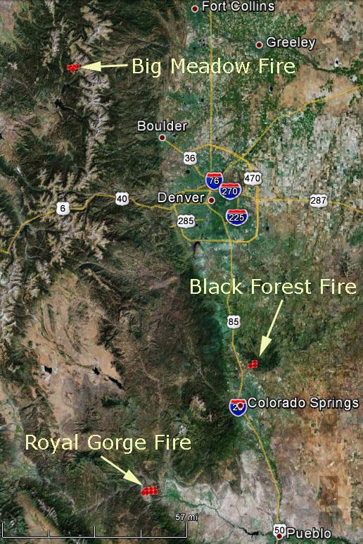
The map below shows the location of the three large fires burning in Colorado.