


Wildfires burning in Indonesia’s peatlands, forests, and agricultural land since July caused the country to produce the world’s highest levels of emissions for September. Now a month later, the fires are still burning, and they continue to reduce the air quality for neighboring countries.
Vast plumes of smoke from the wildfires have been affecting air quality across neighbouring Malaysia and Singapore since the burning began, but recent satellite data from the European Union’s Copernicus Atmosphere Monitoring Service shows the smoke is also deteriorating air quality in countries much further away. The Service’s Fire Emissions Watch found the fires’ densest smoke over southern Sumatra, southern Kalimantan and southern Papua New Guinea, while thinner smoke extends over the Indian Ocean, mainland South-East Asia, the western Pacific and as far as north-west Australia.
“Emissions from wildfires in Indonesia from January to September 2026 were among the highest of the past 24 years,” the Service said on its website.
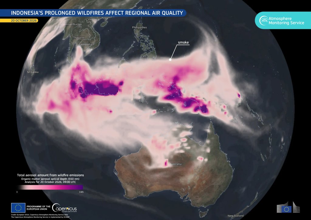
Severe drought across Indonesia’s peatlands caused the months-long outbreak of wildfires encroaching on the site of the country’s new capital city on the island of Borneo.
Over 36% of the world’s tropical peatlands are contained within Indonesia’s borders, and the country’s ongoing drought has made the normally wet landscapes dry enough to ignite, according to NASA’s Moderate Resolution Imaging Spectroradiometer, or MODIS. Droughts have repeatedly produced long-lasting fires that blanket large areas in smoke over the past three decades. The ongoing “super El Niño” has made conditions this year even worse.
“Wildfires occur in Indonesia every year, but some of the most destructive seasons in recent decades came during El Niño, particularly in 1997 and 2015,” NASA’s Earth Observatory said. “The strong El Niño is making the dry season drier over the fire-prone parts of the country and exacerbating burning – just as we anticipated it would.”
PREVIOUS COVERAGE: Underground wildfires in Indonesia trigger world’s highest emissions, spike in respiratory infections







No comment yet, add your voice below!