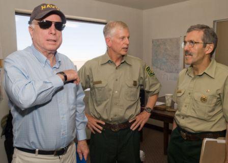
Managers of the Wallow fire spent parts of Saturday and Monday briefing dignitaries that visited the fire area.

More information about the Wallow fire.
Updated progression map of the Wallow fire.

Managers of the Wallow fire spent parts of Saturday and Monday briefing dignitaries that visited the fire area.
More information about the Wallow fire.
Updated progression map of the Wallow fire.


Strong winds on Saturday caused the Wallow fire to cross the fireline along U.S. 180 west of Luna, NM and run for about four miles causing the evacuation of the town. Saturday night the fire was north of the town and had crossed Forest Road 220 between the community and the earlier fire perimeter.
The wind recorded at the Luna weather station during the big fire run on Saturday afternoon was WSW and SW at 16-19 with gusts of 35-38. Saturday’s Red Flag warning is coming in for a repeat performance Sunday from 10 a.m. until 8 p.m. The weather forecast for Luna predicts winds out of the southwest at 32-37 mph with gusts of 47-52. The relative humidity will be in the single digits with a temperature around 80. In other words, the fire behavior on Sunday could be even more extreme than Saturday.
Here is an excerpt from an update the incident management team posted on InciWeb Sunday morning:
Strong southwest winds have caused the Wallow Fire to breach containment lines along US 180, on the east side of the fire. The town of Luna, N.M. has been evacuated. Air resources in defense of Luna were grounded yesterday due to high winds. Structural protection is in place for Luna and also in the broad Blue River drainage, where fire has become established in the San Francisco drainage, Raspberry Creek, Steeple Mesa, Quebec drainage and Horse Canyon areas. Air support began early this morning to work on objectives before the expected wind gusts arrive and air support is forced to be grounded.
InciWeb has more information about the fire and the evacuations.
The map of the east side of the Wallow fire below shows the approximate location of Saturday’s fire run near Luna. The Wallow fire Area Command has posted a map of the fire that was produced after the infrared mapping flight Saturday night. The new updated size of the fire is 511,118 acres.

Update at 7:48 p.m. MT, June 18, 2011:
The Wallow and a new fire, Pacheco Canyon, 6 miles Northeast of Tesuque, New Mexico, (north of Santa Fe) are both putting up a great deal of smoke.

========================================================
Update at 5:36 p.m. MT, June 18, 2011:
The winds have indeed caused a problem on the Wallow fire. A slopover across Hwy. 180 is up and running. Area Command Tweeted this information within the last hour:

The wind at the Luna, NM weather station for the last couple of hours recorded winds out of the southwest or west-southwest at 17-18, gusting up to 37-38 mph. The direct effect of the wind on the air tankers might be enough to make flying 150 above rugged terrain unsafe for the flight crews. The wind would also make it very difficult for the retardant to land on the intended target, blowing horizontally for hundreds of feet before it hits the ground.
The map below shows the area where the fire most likely crossed the fireline and caused the evacuation of Luna. The red squares represent heat detected by satellites at 2:00 p.m. MT on Saturday. Click the image to see a larger version.

==========================================================

The massive, record-breaking Wallow fire in eastern Arizona yesterday reached the dubious distinction of burning over a half-million acres — 500,409 to be exact. Officially, containment is at 38%, a figure not to be confused with the amount of fireline that is being held, which is much higher, at least for now.
Firefighters are worried about the Red Flag warnings that started Friday and go through Sunday, which Wildfire Today covered yesterday. The Luna, NM weather station recorded strong winds on Friday, 17 mph gusting up to 34 at about 5:00 p.m. The firefighters made it through that OK, but the updated forecast for the winds at Luna on Saturday are 28 mph gusting up to 39, and for Sunday, 33 gusting up to 47. On Monday they die down to the 16 mph range.

We have not posted any photos of the Wallow fire for a while, so today we will catch up. Except for the last one, they were all taken on the Wallow fire by Kari Greer for the U. S. Forest Service, who has been taking some great photographs of the fire. More photos are at Flickr. More photos are below.
Continue reading


Updated at 5:32 p.m. MT, June 6, 2011; added updated map of Wallow fire and info about more evacuations.
Arizona is dealing with at least three major fires, Wallow, Horseshoe 2 and Murphy:
Wallow fire
Pushed by strong winds from thunderstorms, the Wallow fire at Alpine, Arizona crossed highway U.S. Hwy. 191 resulting in a flurry of fire activity around Alpine, Nutrioso and Escudilla Mountain. The fire has burned 192,746 233,522 acres according to InciWeb. (The revised acreage is the result of an infrared mapping flight Sunday night.) Containment is at 0%.
More evacuations have been ordered, this time for the communities of Greer and Sunrise. More information is at InciWeb and at the White Mountain Joint Information Center; the phone number is (928) 333-3412, and their web site is 593.org.

Assigned to the fire are:
A red flag warning is in effect on Monday between 10 a.m. and 8 p.m. for low humidity — not good news for firefighters.
Area Command Team 3, with Jim Loach as Area Commander, was dispatched Monday morning to the fires in Arizona. Area Command Teams coordinate activities and firefighting resources among multiple fires and incident management teams.
Some very rough estimates, very rough, based on heat shown in satellite images early Monday morning, indicate that the fire is approximately 6 air miles from Greer, 11 miles from Eagar, 7 miles from Luna, and 35 miles from Morenci.
A call center has been established by the White Mountain Joint Information Center for information, including evacuation information, regarding the Wallow fire. Their phone number is (928) 333-3412, and their web site is 593.org. InciWeb is another source.
(Scroll down to see maps and more information about the Wallow, Horseshoe 2, and Murphy fires.)
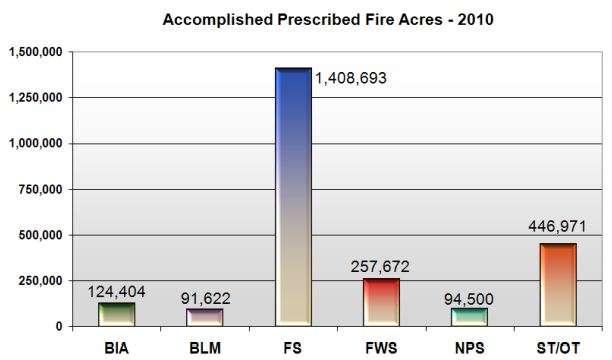
The National Interagency Coordination Center has released a massive compilation of wildfire occurrence and mobilization statistics for 2010. The 70 pages of data is broken up into 5 .pdf documents that can be found HERE. Much of it is very interesting and points out the fact that the 2010 fire season was much less active than normal. (We provided some data on this subject on December 10.)
Below we include some excerpts from the report:
Richard T. Gale passed away at his home in Boise, Idaho Friday night, March 27.
Rick had been an icon in interagency fire management and in the National Park Service for decades. He was one of the first Type 1 Incident Commanders and Area Commanders, was Chief Ranger at Santa Monica Mountains National Recreation Area north of Los Angeles, Chief Ranger of the National Park Service, and the National Fire Management Officer for the National Park Service.
Rick was the Area Commander during the 1988 Yellowstone fires and was the Incident Commander of the first Type 1 All-Risk Incident Management Team formed by the National Park Service in 1991. (The team is shown in the photo below.)
For 25 years he was involved in S-520, Advanced Incident Management and S-620, Area Command as an instructor, evaluator, and Steering Committee Chairperson.

After his retirement in 2002 following 41 years with the NPS he continued his involvement in wildfire by consulting. He served two 3-year terms on the Board of Directors of the International Association of Wildland Fire, retiring from the board in December, 2008 after serving the maximum number of consecutive terms allowed.
I worked with Rick many times in a large variety of situations and incidents. He had the willingness to do the right thing even if it meant battling stupid rules.
When he worked in the NPS Washington office there was a sign on the wall at the end of the hall that said: “What have you done for a park today?”… a concept that is a little too rare in Washington these days.
UPDATE, March 30
The remembrance celebration for Rick Gale will be scheduled for mid-day on Friday, April 3 in Boise, for those who may be making travel arrangements. When more specific details are available, we will post them here.
UPDATE, March 31
THIS POST has the details about the funeral or remembrance service.
House approves $900 million for firefighting
The Associated Press
Article Launched: 09/24/2008 03:01:46 PM PDT
WASHINGTON—The House of Representatives has approved over $900 million for firefighting measures nationwide as part of a massive year-end budget bill.
Included is $610 million for fighting fires, $175 million to get rid of dry brush and other fire fuels, $100 million for rehabilitation and $25 million for firefighter recruitment and retention.
The money was sought by Senator Dianne Feinstein in the wake of lightning-sparked fires in Northern California this summer that charred thousands of acres across the region.
The money is part a $630 billion-plus spending bill. It still must pass the Senate.
Yellowstone Conference
The IAWF/NPS conference, “The ’88 Fires: Yellowstone and Beyond”, started Tuesday in Jackson Hole, Wyoming. Hampered at the last minute by a ban on travel by the U.S. Forest Service, they expect to have 400-500 people there to talk about those fires 20 years ago, and where we go from here.
Rocky Barker, a reporter with the Idaho Statesman and author of “Scorched Earth: How the Fires of Yellowstone Changed America”, is one of the speakers and has an article in the Wednesday edition of his paper. You should read the whole article, but here is an excerpt:
….Today, when a new fire is reported, a ranger decides either to put it out as fast as possible or, if it was started by lightning, he could declare it a “fire-use fire,” such as the South Barker fire near Featherville. There, firefighters act like peacekeepers, monitoring the fire so that it reduces fuels, improves habitat but doesn’t destroy homes, historic cabins or key wildlife features.
But managers want a clear system that allows them to use many different strategies on fires, even if they were started by people. Explaining this new policy and building public support is the key, said Tom Nichols, the National Park Service director of fire and aviation at the National Interagency Fire Center.
So is planning, so managers know before a fire strikes what they want to accomplish across the landscape.
“If we are going to put firefighters in harm’s way, we are going to optimize what we put them there to do,” Nichols said.
Yellowstone officials did not expect the low humidity, the hot weather and most of all the repeated windy days that made the 1988 fires so fierce. They only stopped Sept. 10 when rain and snow finally came.
Politicians and local officials called for the firing of both Daniels and Barbee in 1988. But they both survived and thrived as the public began to recognize the fires were renewing the lodgepole pine forests that burned.
[…]
One after another, fire bosses from the 1988 fires told of how their own views were changed by the size, scale and scope of the 1988 fires. Most of all they spoke with humility.
“Eighty-eight was the first time I saw the world’s best firefighters get their butts kicked,” said Rex Mann, who was an area commander over dozens of fire crews during the Yellowstone fires.
He and others spoke of how they first saw the extreme fire behavior we now take for granted. But eight of the last 10 years have been worse fire years than that seminal year – despite firefighting agencies spending billions of dollars a year and extinguishing 98 percent of all fires.
California: Serial arsonist in Murrieta
An arsonist set six vegetation fires in Murrieta within a 24-hour period, according to spokespersons from the police and fire departments. The largest was 10 acres.
Fire management at Lake Tahoe
Wildland fire at Lake Tahoe, on the California/Nevada border, has been a hot topic for the last few years. They have had their share of fires, smoke is always an issue, and many of the residents are hesitant to create a fire safe barrier around their house or vacation retreat by cutting down a tree or two.
Terri Marceron, the forest supervisor of the Lake Tahoe Basin Management Unit of the U. S. Forest Service, wrote a very clear and lucid article for the Tahoe Daily Tribune that explains the current fire management issues and practices.
More agency administrators should do this.