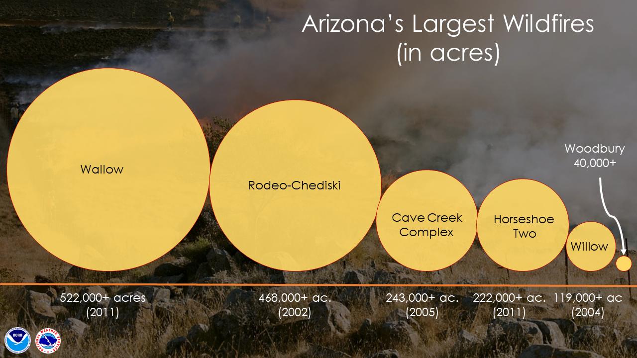
The 40,000-acre Woodbury Fire 12 miles east of the Phoenix suburbs is large, but it is nowhere near as big as the five largest in the recorded history of the state, according to the graphic prepared by the Phoenix office of the National Weather Service.
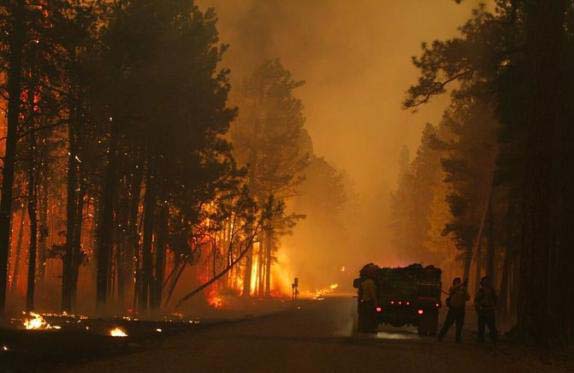
Engine crew works on the Wallow Fire in 2011. Photo by Jayson Coil.
On a recent October day south and west of Alpine, AZ, James Nesslage and Brandon Billy were harvesting a bumper crop of cones from the top branches of a 100-foot tall ponderosa pine. That tree and others like it are survivors of the 538,049-acre Wallow Fire that burned in eastern Arizona and western New Mexico in 2011, most of it within the Apache-Sitgreaves National Forest. The cones being picked will yield the seeds needed to continue the restoration of parts of that vast burn.
James Nesslage climbs a rope rigged in a 100-foot ponderosa pine tree as as he and his crew prepare to harvest seed cones on the Apache-Sitgreaves National Forest southwest of Alpine, AZ. Photo by Tom Story.
Plans to restore the forest began before the Wallow Fire was contained. Initial estimates were that high burn severity over much of the fire area would result in natural regeneration being hampered by a lack of available seed trees.
To have the best chance of survival, seedlings must be grown from cones taken from parent trees in the area. Patrick Murphy, silviculturist on the Apache-Sitgreaves, explained:
Several factors are used in determining where cones are harvested and from which trees seed is collected. The forest has pre-established “seed zones”. These seed zones are geographic locations found throughout the forest. In collecting seed we take into consideration if the parent tree is free from insects, disease, defects, deformity, or forking. The tree should also exhibit superior height and diameter growth. We will plant seedlings in the same seed zone and elevation band where the parent tree is located.
Earlier in the year, there was a larger crew of 20 people harvesting the seed cones. Now as the cone picking season, which began in mid-August, was winding down, there were only two other people; father and son Randy and Brandon James, working that day. It would take two to three hours for each team to completely strip the tree of its cones. “The contract specifies eighty-percent (of the cones on each tree)” said Mr. Nesslage, “but we try to do better than that”. The pine that the James duo picked that morning barely produced a bushel of good cones while the tree that Mr. Nesslage and Mr. Billy harvested yielded over three bushels.
Brandon Billy works his way out on a limb as James Nesslage (mostly hidden at right) uses a hook to pull the cone laden tip of a limb close to Mr. Billy during the seed cone harvest. Photo by Tom Story.
A general contractor in the construction business, Mr. Nesslage came across a solicitation for a seed cone harvesting contract on the Federal Business Opportunities website and thought it was a chance to put some of his climbing experience to good use. “Go camping, climb trees and get paid for it! Sweet!” was his reaction. He was awarded a contract and started picking in 2012. He admitted that the learning curve was a little steep at first but was able to complete the harvest. The cone crop in 2013 was poor and was not picked, so when Mr. Nesslage’s teams returned to the woods this year, not only was there more to harvest, they had a larger crew and more knowledge of how to do the job better and more efficiently.
A report has been released that had the objective of determining if fuel reduction treatments are effective in reducing the severity and cost of wildland fires. It was prepared for the U.S. Department of Interior’s Office of Wildland Fire by the Ecological Restoration Institute at Northern Arizona University. The reason it was written is interesting, according to the report: (emphasis added)
The Office of Management and Budget, Government Accountability O ffice and the United States Congress have repeatedly asked the Offi ce of Wildland Fire in the Department of Interior and the United States Forest Service to critically examine and demonstrate the role and eff ectiveness of fuel reduction treatments for addressing the increasing severity and cost of wildland fi re. Federal budget analysts want to know if and when investments in fuel reduction treatments will reduce federal wildland fire suppression costs, decrease fi re risk to communities, and avert resource damage.
The report has a catchy title: The efficacy of hazardous fuel treatments: A rapid assessment of the economic and ecologic consequences of alternative hazardous fuel treatments: A summary document for policy makers.
Here are a few of the conclusions reached by the 12 authors and researchers:
Studies that use the avoided cost approach to examine the cost of fire demonstrate that treatments result in suppression cost savings.
Modeling studies that evaluate the effectiveness of fuels treatments in terms of changes in wildland fi re size, burn probabilities, and fi re behavior demonstrate that fuel treatments applied at the proper scale can influence the risk, size, and behavior of fire therefore reducing suppression cost.
Modeling demonstrates that fuel reduction treatments are effective at reducing fire behavior (severity) where implemented, and can successfully reduce fire risk to communities.
Although few studies exist on the topic, fuel reduction treatments significantly enhance the price of adjacent real estate, whereas homes in close proximity to a wildfire experience lower property values.
Two men who are cousins have been ordered to pay $3.7 million for accidentally starting what became the largest fire in Arizona history. Last May David and Caleb Malboeuf left a campfire unattended in the eastern part of the state which escaped and became the Wallow Fire, eventually burning 538,040 acres, which includes 15,407 acres after it crossed the border into New Mexico.
The Malboeufs have asked the U.S. Magistrate to set the monthly payments for Caleb at $500 and $250 for David. At that rate it will take them about 4,900 years to pay it off.
The $3.7 million only includes claims that have been filed and approved by the court for actual damages that occurred, mostly on private land. The U.S. Forest Service agreed not to seek repayment for $79 million in suppression costs. However the agency and any of the victims could later initiate civil actions against the Malboeufs.
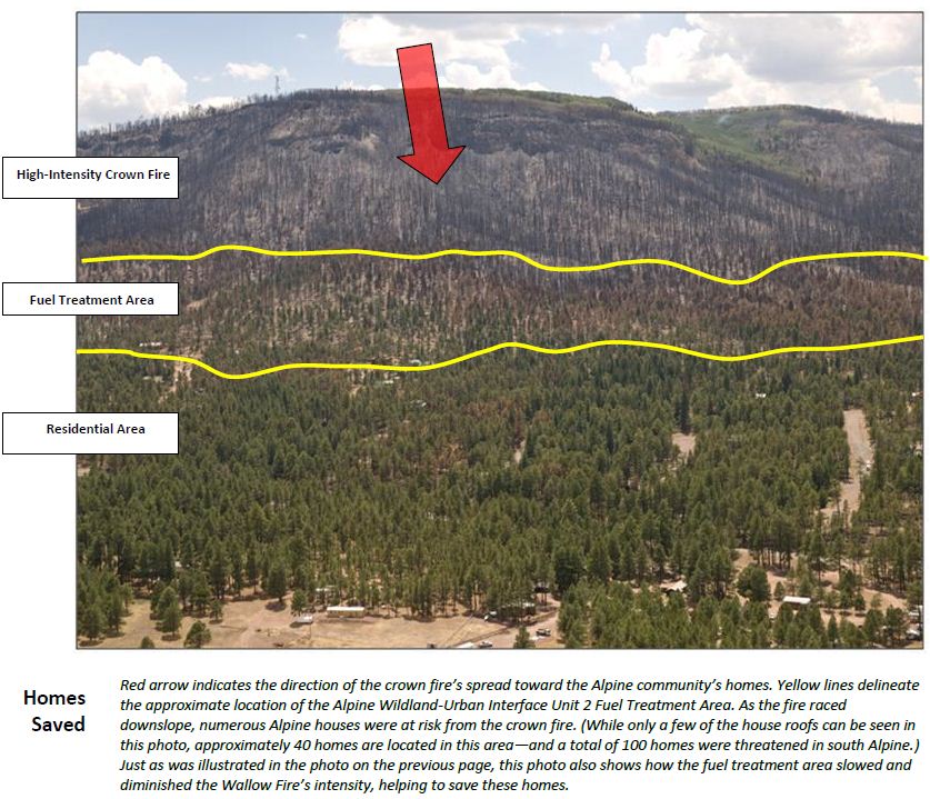
A report has recently been released that highlights several examples during the Wallow fire when fuel treatments, modifying the vegetation near populated areas, were effective in reducing the intensity of the fire, making it possible for firefighters to remain in the area and prevent structures from burning. The fire burned in eastern Arizona in May and June, 2011. It burned 522,900 acres and 32 homes, becoming the largest fire in the history of the state.
Fuel Treatment Units Slow the Wallow Fire– Allow Firefighters to Safely Attack
As the main fire enters the ½ mile-wide White Mountain Stewardship Fuel Treatment units located above Alpine, the blaze drops from up in the tree crowns down to the surface level. The fire’s rate-of-spread dramatically slows. Thanks to the influence of these previously developed treatment units—implemented beginning in 2004—flame lengths are now low enough to allow firefighters to safely attack the fire and protect homes and property.
Engines and crews successfully extinguish the spot fires. To further protect residents’ houses, these firefighters also conduct low-intensity “firing operations” from roadways and other fuel breaks. These aggressive firefighting suppression actions continue throughout the evening—successfully halting the spread of the Wallow Fire into the community of Alpine. In fact, all of this community’s structures—but one—are saved from the fire’s attack. (Actually, this single structure burned several days later when an ember—most likely transported downwind during the June 2 crown fire run—smoldered for several days before flaring up.)
An image from the Wallow fire fuel treatment report. Click to enlarge.
The report was written by Pam Bostwick, Jim Menakis, and Tim Sexton, all of the U. S. Forest Service.
The International Association of Fire Chiefs published an article today about a Liaison Officer being used on the record-setting, 532,086-acre Wallow fire in eastern Arizona. It is not uncommon for a Liaison Officer to be assigned to large, complex, multi-jurisdictional fires, but the article makes the point that this is the first time since the 2002 Rodeo-Chediski fire that the Arizona Fire Chiefs Association has provided one to a fire. Serving in that role was Assistant Fire Chief Chris Jessop of the Show Low Fire District until he was relieved by Northwest District Fire Chief Jeff Piechura. They have been serving as points of contact for the five fire departments and other local agencies in the Wallow fire area.
The Liaison Officer is assigned to the Command Staff and works directly for the Incident Commander, though in this case they may be working for the Area Commander.
Officially, this is how the position is described:
Incidents that are multijurisdictional, or have several agencies involved, may require the establishment of the Liaison Officer position on the Command Staff.
The Liaison Officer is the contact for the personnel assigned to the incident by assisting or cooperating agencies. These are personnel other than those on direct tactical assignments or those involved in a Unified Command.
Liaison Officer major responsibilities and duties:
Be a contact point for Agency Representatives.
Maintain a list of assisting and cooperating agencies and Agency Representatives.
Assist in establishing and coordinating interagency contacts.
Keep agencies supporting the incident aware of incident status.
Monitor incident operations to identify current or potential inter-organizational problems.
Participate in planning meetings, providing current resource status, including limitations and capability of assisting agency resources.
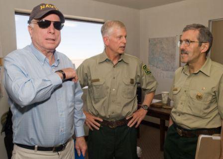
Area Commander Jim Loach, on the left, briefs Rep. Jeff Flake, Sen. John McCain, and Tom Harbour, Director of Fire and Aviation for the USFS. June 18, 2011. Photo by USFS.
Managers of the Wallow fire spent parts of Saturday and Monday briefing dignitaries that visited the fire area.
Sen. John McCain, Thomas Tidwell (Chief of the Forest Service), and Tom Harbour (Director of Fire and Aviation, USFS). June 18, 2011. Photo by USFS.Norm Walker, one of the four Incident Commanders on the Wallow fire, briefs Secretary of Interior Ken Salazar on June 20, 2011. Photo: US Army Pfc Danielle J. Sargent AZNG
The Wallow fire has been burning for three weeks, becoming the largest fire in the history of Arizona. When a new fire started on Sunday on the same national forest, someone named it “Willow”. An interesting choice.
InciWeb, June 20, 2011
A spokesman for the Wallow fire told us today that the Wallow fire got its name from the Bear Wallow Wilderness where it started.
Smoke from the Wallow fire, June 16, 2011. USFS photo
Strong winds on Saturday caused the Wallow fire to cross the fireline along U.S. 180 west of Luna, NM and run for about four miles causing the evacuation of the town. Saturday night the fire was north of the town and had crossed Forest Road 220 between the community and the earlier fire perimeter.
The wind recorded at the Luna weather station during the big fire run on Saturday afternoon was WSW and SW at 16-19 with gusts of 35-38. Saturday’s Red Flag warning is coming in for a repeat performance Sunday from 10 a.m. until 8 p.m. The weather forecast for Luna predicts winds out of the southwest at 32-37 mph with gusts of 47-52. The relative humidity will be in the single digits with a temperature around 80. In other words, the fire behavior on Sunday could be even more extreme than Saturday.
Here is an excerpt from an update the incident management team posted on InciWeb Sunday morning:
Strong southwest winds have caused the Wallow Fire to breach containment lines along US 180, on the east side of the fire. The town of Luna, N.M. has been evacuated. Air resources in defense of Luna were grounded yesterday due to high winds. Structural protection is in place for Luna and also in the broad Blue River drainage, where fire has become established in the San Francisco drainage, Raspberry Creek, Steeple Mesa, Quebec drainage and Horse Canyon areas. Air support began early this morning to work on objectives before the expected wind gusts arrive and air support is forced to be grounded.
InciWeb has more information about the fire and the evacuations.
The map of the east side of the Wallow fire below shows the approximate location of Saturday’s fire run near Luna. The Wallow fire Area Command has posted a map of the fire that was produced after the infrared mapping flight Saturday night. The new updated size of the fire is 511,118 acres.
The winds have indeed caused a problem on the Wallow fire. A slopover across Hwy. 180 is up and running. Area Command Tweeted this information within the last hour:
The wind at the Luna, NM weather station for the last couple of hours recorded winds out of the southwest or west-southwest at 17-18, gusting up to 37-38 mph. The direct effect of the wind on the air tankers might be enough to make flying 150 above rugged terrain unsafe for the flight crews. The wind would also make it very difficult for the retardant to land on the intended target, blowing horizontally for hundreds of feet before it hits the ground.
The map below shows the area where the fire most likely crossed the fireline and caused the evacuation of Luna. The red squares represent heat detected by satellites at 2:00 p.m. MT on Saturday. Click the image to see a larger version.
Map of east side of the Wallow fire, heat data 2:00 p.m. MT, June 18, 2011. MODIS/Google Earth
Firefighter uses a pistol-like firing device to ignite a burnout on June 12, 2011
The massive, record-breaking Wallow fire in eastern Arizona yesterday reached the dubious distinction of burning over a half-million acres — 500,409 to be exact. Officially, containment is at 38%, a figure not to be confused with the amount of fireline that is being held, which is much higher, at least for now.
Firefighters are worried about the Red Flag warnings that started Friday and go through Sunday, which Wildfire Today covered yesterday. The Luna, NM weather station recorded strong winds on Friday, 17 mph gusting up to 34 at about 5:00 p.m. The firefighters made it through that OK, but the updated forecast for the winds at Luna on Saturday are 28 mph gusting up to 39, and for Sunday, 33 gusting up to 47. On Monday they die down to the 16 mph range.
Mormon Lake Hotshots refilling drip torches during a night burn operation on the 275 Road near Alpine, AZ, June 12, 2011.
We have not posted any photos of the Wallow fire for a while, so today we will catch up. Except for the last one, they were all taken on the Wallow fire by Kari Greer for the U. S. Forest Service, who has been taking some great photographs of the fire. More photos are at Flickr. More photos are below. Continue reading