Followup on downgrading the Santa Maria tanker base

On May 2 Wildfire Today covered the downgrading of the Santa Maria, California air tanker base from a full service base to a “call when needed” base.  When the Jesusita fire burned into Santa Barbara 4 days later ultimately destroying 78 homes and burning 8,700 acres, using the Santa Maria base instead of Porterville could have saved 120 miles round trip each time the air tankers reloaded.

S2 being reloaded. Photo: Bill Gabbert

Emergency medical personnel refer to the “Golden Hour”, during which it is crucial that seriously injured victims receive a very high level of patient care. It is also crucial that overwhelming force be used during the first four hours, the Golden Four Hours, of the initial attack stage of a wildland fire.  Quick, efficient suppression during the Golden Four Hours can save many acres, many dollars, and in some cases private property, homes, or even lives.

Closing or downgrading air tanker bases, closing fire stations, or laying off firefighters may cost a lot more in the long run, than the short term dollars that may be saved by short-sighted bureaucrats–some of whom have absolutely no personal knowledge or experience in fire suppression. Fire suppression decisions should be made by firefighters.

Southern California has evolved into having a year-round fire season. With the urban interface they have, their resources and tools need to be geared up all year to contain fires by 10 a.m. the next day. It was a good idea in 1910, and it still is today.

The AP has picked up on the story, and has quotes from Gail Kimbell, the Chief of the U.S. Forest Service:

The head of the U.S. Forest Service said she is reluctant to overturn a policy that caused tanker planes to fly extra distances while fighting a California wildfire because the agency did not yet have a contract in place to use a nearby airport.

The tankers had to fly an additional 120 miles round trip to obtain supplies — delaying response to the fire, which burned 100 homes in Santa Barbara, forced more than 30,000 people to evacuate and torched more than 13 square miles.

Forest Service Chief Gail Kimbell said the agency will review the specifics of the Santa Barbara blaze, but added that she would not want the agency to have year-round contracts with private companies to help fight wildfires.

“A permanent fire season? I hope we never get to that,” she told The Associated Press.

Setting up agreements to provide retardant and other supplies “is an expense of public money. We want to be mindful before we commit to anything,” Kimbell said.

At the same time, she acknowledged that global warming and other factors have led to longer fire seasons that now stretch well beyond mid-May to November.

“Fire season keeps expanding on both ends,” Kimbell said, adding that the length of the fire season is a key factor as officials set up contracts with private companies and airports to assist the government in what has become a billion-dollar-a-year battle against wildfires.

“We try to be prepared … should events occur, and we use the best data we have, but you’ll never have all the answers,” particularly when most contracts are signed a year in advance, Kimbell said.

Three aircraft were able to resupply once at an airfield in Santa Maria, Calif., 60 miles north of the blaze, but they were later diverted to another airport about 120 miles away after officials realized a supply contract wasn’t in place at the Santa Maria airport. State and federal officials say it’s impossible to know what effect the airport confusion had on efforts to stamp out the Santa Barbara blaze, but said that being able to land at Santa Maria would have saved time.

Planes made multiple trips to Porterville, Calif., last week before the Santa Maria airfield was opened to the aircraft on May 6, cutting the length of resupply missions in half. The Forest Service had not completed a contract, which usually runs from May 15 to Nov. 15, with two service providers at the airport, said spokesman Jason Kirchner.

The 8,700-acre Santa Barbara fire destroyed 78 homes and damaged 22 others, fire officials said. The week-old blaze was 80 percent contained as of Tuesday, with costs totaling more than $12.2 million.

Jesusita fire burn over preliminary report

CalFire has released the “Blue Sheet” or preliminary report about four burn overs that occurred on the Jesusita fire last week.  We were aware of the one in which firefighters took refuge in a structure and suffered burns. Two of them remain hospitalized at Grossman Burn Center near Los Angeles.

But it turns out that there were four burn over incidents that involved firefighters sheltering in structures or their vehicles.

Below are the entire contents of the report.

=========================================================

BLUE SHEET

PRELIMINARY SUMMARY REPORT

Firefighter Burn Injury

Wednesday, May 6, 2009

Jesusita Fire

CA-LPF-001479

Firefighter Burn Injury Investigation

CA-CSR-000031

This Preliminary Summary Report is intended as an aid in accident prevention, and to provide factual information from the first 24 hours of the accident review.  To that end it is published and distributed within a short time frame.  Information contained within may be subject to revision as further investigation is conducted, and other reports and documents are received.

Synopsis

On the afternoon of Wednesday, May 6, 2009, several engine companies assigned to structure protection on the Jesusita Fire, North of the City of Santa Barbara, experienced extreme fire behavior related to the surfacing of strong down slope (sundowner) winds typical of the area.  This sudden increase in fire behavior resulted in the burn over of a Ventura County engine company, causing burns and smoke inhalation to the engine crew members.   During this same fire behavior event, several other engine companies and overhead personnel were required to take refuge in structures and apparatus. This event resulted in significant damage to two Type One engines, two light duty vehicles, and minor injuries to fire personnel.

Narrative

Strike Team VNC 1580A was assigned to structure protection in the Spyglass Ridge Road area of Mission Canyon. One of the Engine Companies had deployed two attack lines around structures, and one line for engine protection. At approximately 1610 hrs, a strong down canyon wind spread the fire toward the structure.  The firefighters retreated into the structure and were forced out when the structure became well involved.  Three Firefighters were transported to the Grossman Burn Center in Sherman Oaks where the Firefighters were admitted for burns and smoke inhalation.

Strike Team LFD 1001A was assigned to structure protection in the Holly Road area of Mission Canyon. During the increased fire behavior, individuals assigned to two light duty vehicles took refuge inside structures.  The two light duty vehicles were destroyed by fire.  One minor eye injury was reported.  The individual was treated and released at a local hospital.  Civilians on Holly Road that chose to stay after the evacuation order was given remained in their home through the increased fire behavior event. These civilians were escorted from the area afterwards with no injuries and minor damage to the structure.

Strike Team LFD 1002A was assigned to structure protection in the Palomino Road area.  Strike Team LAC 1240A responded from staging to assist Strike Team LFD 1002A.  In the process of turning around one engine from Strike Team LAC 1240A, the fire behavior increased.  The Engine Company attempted to defend the engine.  As the fire behavior continued to increase, the Engine Company took refuge in the closest structure.  The structure subsequently caught fire.  The Engine Company escaped the structure without injury, returned to the Engine and exited the area.  The engine sustained minor damage.

Strike Team XVE 1550A was assigned to structure protection in the Tunnel Road area.  A Santa Paula Engine from the Strike Team was providing structure protection as the fire behavior increased.  The Engine Company took refuge in a structure.  Due to changing fire behavior the engine was repositioned and received minor damage while backing.  An engine company from Ventura City, also assigned to the Strike Team, took refuge in their engine while engaged in structure protection in the same area. While inside the engine, fire shelters were taken from the plastic containers but not deployed.   No injuries occurred.

Recommendations For Immediate Corrective Actions

  • Assure resources assigned to staging are fully briefed on current and expected weather and fire behavior.
  • Have communications broadcast significant changes in fire weather.
  • Insure all personnel utilize appropriate PPE at all times.


Update on Jesusita fire

Fog has allowed firefighters to make significant progress on the Jesusita fire near Santa Barbara, California. A more refined count on structures burned resulted in the new figures of 31 77 homes and 2 detached garages being destroyed, and 47 22 other homes being damaged (CalFire changed their numbers). About 8,733 acres have burned and the 4,543 personnel assigned to the fire have achieved 55% containment.

All but the residents of 140 parcels have been allowed to return to their homes as mandatory evacuation orders are being lifted.

UPDATE @ 7:40 a.m. PT, May 11

The fire is 65% contained.  According to InciWeb:

With the influence of the fog the fire continues to lay down. No significant fire growth. Foothill Road (HWY 192) opened at 1000 today while HWY 154 remains closed. Some areas on the West side of the fire remain evacuated. Repopulation has occurred resulting in 90% of the evacuated area able to return home.

Joe Waterman, the Incident Commander for the fire, said investigators have concluded that the fire was caused by someone using a power tool to clear brush.  The fire started near the Jesusita trail.

Los Angeles County supervising fire dispatcher Art Marrujo said a private weed abatement crew was using machinery to clear brush when a spark from their equipment started the fire. Other reports said the device being used was a weed wacker.


Map of Jesusita fire perimeter

It’s tough to find maps that show the perimeter of the Jesusita fire, but Northtree Fire put this one together with data from the USGS wildfire viewer, geomac.usgs.gov

The data is from May 6 at 4 p.m, before the big run that burned dozens of homes that evening.

KEYT reported at 8:00 p.m. PT that 2,739 acres and 75 residences have burned in the Jesusita fire.  The fire has jumped some control lines on the west side and is very active on that flank, moving toward Highway 154. The east side is also active.

Jesusita fire: Engine crew takes refuge in house

From the AP:

SANTA BARBARA, Calif. — Battalion Chief Scott Smith’s yellow jacket reeked of wood smoke and his eyes were red with exhaustion at the Emergency Operations Center.

Earlier, one of his crews nearly lost its engine to the flames and Smith fetched them out of a burning home where they had taken shelter Wednesday amid a wildfire near Santa Barbara that had charred 500 acres and driven thousands from their homes.

“The fire front came up the hill fast and got in front of the engine,” which was backed into a driveway at the end of a narrow street, said Smith, a firefighter for 30 years who plans to retire next year.

The four-man crew on the engine — No. 70 out of Malibu — were wetting down a home when they ran out of water, he said. They had no time to hook up to a hydrant down the street as the flames fast approached so the men took shelter in the home’s garage, which Smith said is a standard procedure. When it got too hot in the garage, they moved inside the house.

“They were safe in there for a certain amount of time,” Smith said.

Once the bulk of the fire had passed, Smith and another firefighter went up the hill to get them out.

“When I got there the side of the garage was on fire,” Smith said.

Smith fetched his crew out of the home and they struggled to connect the engine to a water line.

“Heat and smoke had killed the engine and we had to cool it down and restart it,” he said.

“By the time we got done with the engine, the house was already too far gone.”

In the blur of the moment, the 54-year-old firefighter didn’t notice anything about the home, or even which street he was on, because his sport utility vehicle’s GPS didn’t report it.

“No one got hurt, just a little dirty,” he said, spreading his hands as if to demonstrate that he still had all ten dusty fingers. One of the firefighters felt sick because of dehydration, was treated at a hospital and later returned to work.

Engine 70 made it down the hill back to headquarters on its own power. But it was streaked with soot and smoke and its plastic signals had melted slightly in the heat.

“It was either the guys or the house,” Smith said, “and with me it’s always my guys.”

Update on the Santa Barbara Jesusita fire

Photo: Lisa Slavid, 8:45 p.m. PT, May 5

From a press conference that just finished at 7:30 a.m. PT, featuring Chief Tom Franklin, of Santa Barbara County FD.

  • The winds last night were not as strong as expected, so the spread of the fire was limited.
  • The current size is 196 acres.  Earlier estimates of 420 acres were hampered by the smoke obscuring portions of the perimeter.
  • Three helicopters worked the fire last night using night vision equipment. Five helicopters will be working the fire today.
  • The spread of the fire has been slowed by the high live fuel moisture and the moderate relative humidity. But a high live/dead ratio in the area is a factor that accelerates the rate of spread.
  • Winds late this afternoon are expected to be 30 mph with gusts up to 40 to 55.
  • At least 1,200 homes have been evacuated.
  • The fire is about 1/2 mile away from homes.
  • It is between the old Tea and Gap fires.
  • Containment is at 0%.

California: Freeway fire report released

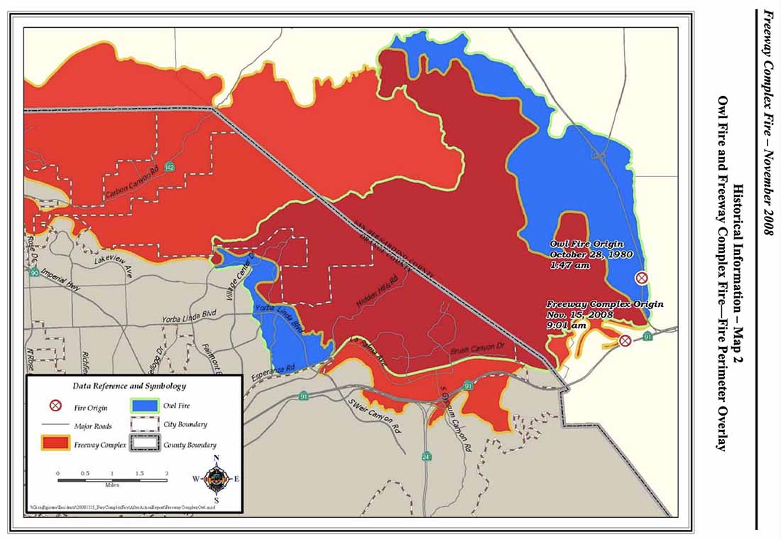
Map, Freeway Complex
Map, Freeway Complex, from OCFA AAR.

The Orange County Fire Authority has released a 128-page report (large 8Mb file) about the devasting Freeway Fire that started November 15, 2008 in southern California and destroyed 203 homes in Orange County, including the communities of Yorba Linda and Anaheim Hills.

The Orange County Register has an excellent article on the report, but here are some excerpts outlining some of the key issues from their account:

=============

The major recommendations include improving radio communications, training crews in battling house fires near wildland areas, working with local water agencies to identify and rectify weaknesses in water systems, and developing a rapid-mobilization plan in large-scale emergency situations.

Yorba Linda fire
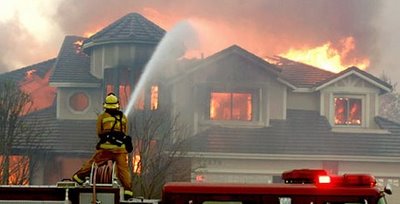
Firefighters try to suppress a fire in a structure in Yorba Linda on the Freeway fire in November, 2008.

Nearly 18 months after the Santiago fire raced through Orange County’s canyons, tight economic times have forced the Fire Authority to postpone several major recommendations after that fire, including replacing its part-time hand crew with a full-time crew and adding a fourth firefighter to wildland engines to meet federal standards. The same recommendations were echoed in the Freeway Complex review.

The plan was to pinch off the fire early. But hundreds of gallons of water destined to be dropped by helicopters on the fire had to be diverted and dropped on a Corona fire engine crew that had been overrun by flames after going off-road to try to fight the flames. The Corona crew’s decision placed them in a “dangerous position,” between the fast-moving fire and unburned brush, the report said. The crew was saved, but flames raced west toward Yorba Linda, throwing embers more than a mile in front of the fire.

Off-duty Fire Authority crews were mounting their own defenses, hijacking three engines and heading to the firefight, creating serious safety and accountability issues. Command staff scrambling for extra engines to send to the firefight spent up to 12 hours trying to find the maverick engines, the report said.  “These firefighters are heroes,” Fire Authority union President Joe Kerr said. “These firefighters came in off-duty to try to do everything they could to save homes. A lot of homes were saved because of them. You’re not going to find more dedication than that.”

“We take crew accountability very seriously,” Concepcion said. “We want to make sure this never happens again.”  The involved firefighters have been interviewed but were not disciplined, Kerr said.

Two strike teams – a total of 10 fire engines – were ordered by Battalion Chief Rick Reeder to stage at Station 53 on East La Palma in Yorba Linda to get ahead of the fire. “In my mind, what was burning in Corona was already done,” Reeder said. “It was not the piece to worry about.”

Strike team leaders ignored Reeder’s order, self-dispatching instead to Corona, the report said. With the original order unfilled, strike teams did not arrive into Yorba Linda until 11 a.m. – nearly 2 hours later. The first Yorba Linda house was already burning. Command officers have a “certain amount of latitude,” Concepcion said. “They must have thought there was something more pressing in Corona,” he said.

Fire stations were emptied to fight the Laguna fire in 1993, but entire OCFA battalions were left fully staffed during the Freeway Complex fire, officials said. “We had two fires burning close to each other, and we didn’t know what caused them,” Concepcion said. Extra strike teams were ordered from other counties, but it took time for them to arrive.

Multiple new fires in southern California

More fires have started in southern California and are being pushed by the Santa Ana winds. We will post maps of the fires as they are available.

“Freeway” fire near Corona and Yorba Linda

UPDATE @ 10:07 p.m. Saturday

The Freeway (or Corona or Yorba Linda) fire and the Landfill (or Brea) fire are still two separate fires and have not burned together yet. However, firefighters are confident that they will merge and it could happen as early as dawn on Sunday. If they merge at Carbon Canyon Road (Highway 142) it will be a real challenge for firefighers to protect the homes in that area if they have fires approaching from two different directions.

UPDATE @ 8:13 p.m. Saturday

Below is a screen capture from infrared imagery taken by a U.S. Forest Service research aircraft at 2:30 p.m. today. the lighter brown areas are burned, and the red is active fire. You can view the original imagery, and zoom and pan, by clicking HERE.

At that site you can then click on “Local Area Map for the Freeway Fire (Google Maps) with thermal overlay” which will overlay the thermal map over a Google street map. Be patient, it takes a while to load. Then you can toggle on or off the overlay by checking the box on the left side (because the overlay obscures the Google map).


The last size reported on the fire late this afternoon at 9:00 p.m. was that it is 2,000 5,870 acres and 5% contained.

Structures lost on the Freeway fire, according to a spokesman on the fire:

  • 14 structures in Corona
  • 10 in Anaheim Hills
  • One 40-unit apartment complex in Anaheim Hills
  • 30 structures in Yorba Linda

More information is available about earlier report about the two firefighters that were injured, from Jon Dorsey of the CalFire Southern Operations Center.

At approximately 10:00 hrs, 1 Fire Captain, 1 Engineer and 2 Firefighters from Corona City Fire were injured while performing direct attack on the fire in the Green River Community. They were overcome by fire and all four suffered minor smoke inhalation injuries, with two receiving minor burns. Two were treated and released from Arrowhead Regional Medical Center, while the others were sent to Corona Regional Medical Center, where one remains at this time.

WEATHER:
The high wind warning has been canceled, but the red flag warning will continue until 4 p.m. Sunday. Temperatures will remain in the 80s until Wednesday, when it should be cooler.

UPDATE @ 4:42 p.m. Saturday

Below is a map showing thermal imagery from a satellite. The red areas are the two fires west of Corona in the Yorba Linda, Brea, and Anaheim areas. The western most one is the Brea or Dump fire. The eastern most one is the Freeway fire. It appears that this imagery is from late this afternoon. The Brea fire seems to have crossed the 57 freeway, and we already knew the Freeway fire was well established south of the 91.

Click on the map to see a larger version.


————————————

UPDATE @ 2:27 p.m. Saturday

A 250-unit apartment complex south of the 91 freeway near Santa Ana Canyon Road and some single family dwellings in the same area are fully involved.

Here is an updated map that shows the approximate location of the Freeway fire west of Corona. Click on it to see a larger version.

————————————-

UPDATE @ 1:45 p.m. Saturday

The fire crossed the 91 freeway in two places and 3,100 homes in the Anaheim Hills area (south of 91 and west of 241) are under an evacuation order.

—————————
11:40 a.m. Saturday

The DC-10 air tanker making a drop on the Freeway fire near Corona. It dropped continuously for 10 seconds, much longer than smaller air tankers. Oddly, there was a smaller twin-engine plane flying closely on the side of the DC-10, unlike lead planes which fly some distance ahead of air tankers.

Here is a map that shows the approximate location of the Freeway fire. Click on the map to see a larger version.

This fire, named Freeway, started late this morning and as of 11:40 a.m. PT has already burned 800-1,000 acres and has damaged or destroyed 12 homes. It is on the north side of the 91 freeway near Green River Road. It has burned into Yorba Linda where evacuations are in progress and some homes burned near Merryweather Circle.

An engine crew was burned over according to LA channel 7. Two firefighters have minor injuries and were treated at a hospital.

Fire in Brea (“Landfill” fire)

UPDATE @ 3:40 p.m. PT Saturday

The fire has burned quite a distance to the west and jumped the 57 freeway for a while but firefighters picked up that portion that crossed the freeway. A reporter from Fox 11 is at the fire edge on Wildcat Way just north of W. Lambert Road in Yorba Linda. HERE is a link to a map of that location.

Farther to the east at Hidden Hills Rd. and Greencrest Dr. many mega-mansions are burning to the ground. The situation is complicated by the fact that there is no water pressure at all in the water system. Firefighters are emptying the tanks in the engines, then leaving the area to get water, then returning again.

The director of the Yorba Linda Water District said that there are multiple pumping stations that pump water into some of the higher elevations that are burning now, and at least one of the pump stations burned. They are investigating the possibility of bringing in a pump to replace the one that burned. So… the fire suppression infrastructure works fine… until there is a fire. Just a idea: Make the pumping stations resistant to fire.

———————————
11:40 a.m. Saturday

This is a new fire a mile or two or three west of the Freeway fire. It is smaller than the Freeway fire, but no additional information is available. It may have been a spot from the Freeway fire.

BTU Complex: 50 homes burn in Concow

At least 50 homes burned Tuesday in the city of Concow, California as the BTU (or Butte) Lightning Complex swept through communities 20 miles east of Chico. The entire east half of the city of Paradise, a city of 26,000, is under evacuation orders, and some areas of Magalia have also been evacuated.

If the weather forecast is accurate, Paradise and Magalia are under a severe threat from the fire. Firefighters hope to stop the fire at the West Branch of the Feather River just east of the city.

This is the third time in the last few weeks that Paradise has had a bulls eye painted on it by fires heading in their direction.

HERE is a link to a very interesting map of the fire in the area made by the newspaper in Chico, the Chico Enterprise Record. This is an amazing use of Google Maps. You might call it groundbreaking. There is a ton of information there—I hope the data is accurate. Click on the icons on the map to get details.

Record high temperatures as high as 115 in the valley on Tuesday contributed to the extreme fire behavior. Foothill temperatures were expected to be in the 90s on Tuesday.

The Weather forecast for Paradisc, CA: (note that the maximum relative humidities at night only go up to 30% and 26%)

Tuesday night: Areas of smoke. Clear, with a low around 79. Northeast wind between 10 and 15 mph, with gusts as high as 18 mph. RH 30%.

Wednesday: Areas of smoke. Sunny and hot, with a high near 110. North northwest wind between 5 and 10 mph. RH 10%.

Wednesday Night: Areas of smoke. Clear, with a low around 77. North wind between 7 and 13 mph. RH 26%

Thursday: Areas of smoke. Sunny and hot, with a high near 108. Northeast wind 6 to 8 mph becoming west. RH 11%.