
Approximately 400 race horses at a training facility were freed from their stalls as the fire rapidly approached in December, 2017.
Continue reading
Approximately 400 race horses at a training facility were freed from their stalls as the fire rapidly approached in December, 2017.
Continue reading
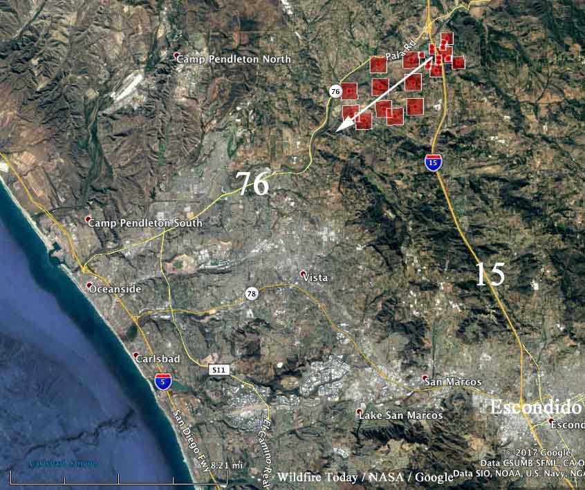
The fire ran for six miles along Highway 76 Thursday afternoon in Southern California.
Continue reading
Above: The view of the Lilac Fire as seen from an HPWREN camera on Red Mountain near Fallbrook, CA, looking south at about 1:45 p.m. PST December 7, 2017.
(UPDATED at 4:25 p.m. PST December 7, 2017)
CAl FIRE reports that the Lilac Fire south of Temecula, CA has grown to 2,500 acres. New evacuation order: South of Hwy 76, West of I-15 Freeway, North of Gopher Canyon Rd, East of East Vista Way & Mission Rd.
Two civilian burn victims were treated & transported.
(All articles on Wildfire Today about the Lilac Fire can be found HERE.)
A temporary evacuation point has been set up at the Carlsbad Forum, and a temporary evacuation center has been established at Great Oak High School, 32555 Deer Hollow Way, Temecula, CA.
Approximately 20 structures have been destroyed.
A horrible sight in San Diego’s North County. The fast-moving #LilacFire ripped through homes in Bonsall, burning the structures to the ground.
We have live, continuing coverage here: https://t.co/9nrs2wwmVu pic.twitter.com/86m5YHTjuT— #NBC7 San Diego (@nbcsandiego) December 8, 2017
Chilling images from SkyFOX
Monserate mobile estates near Bonsall
2,000 acres scorched #LilacFire https://t.co/Ir2XP8Sg8x pic.twitter.com/uxcXvMfyto
— FOX 5 San Diego (@fox5sandiego) December 8, 2017
****
(UPDATED at 2:40 p.m. PST December 7, 2017)
The Lilac Fire south of Temecula, CA “is growing at a dangerous rate of spread with 1,000 structures threatened”, a spokesperson for CAL FIRE said at 2:25 p.m. Five structures have been destroyed and Highway 76 is closed in both directions.
In addition to federal and state aircraft working the fire now, CAL FIRE is making arrangements to use military helicopters from Camp Pendleton and Naval Air Station North Island during the day and night flying helicopters from San Diego Fire-Rescue.