(Originally published at 9:48 PDT, August 1, 2014)
Oregon Gulch Fire, August 31. Photo by Don Hall.
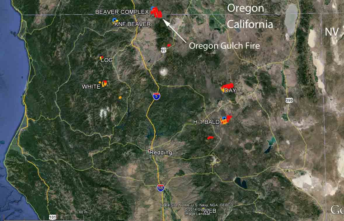
The Oregon Gulch Fire, 18 mile southeast of Ashland, Oregon, was extremely active on Thursday, burning across the California-Oregon border. It is part of the Beaver Complex of fires that started July 30 from lightning. The complex also includes the Salt Creek Fire.
The Oregon Gulch Fire had only burned 100 acres Thursday morning, but by Friday morning it had grown to about 7,500 acres in or near the Cascade-Siskiyou National Monument. Evacuations are taking place in the area. An Oregon Department of Forestry incident management team has been dispatched.
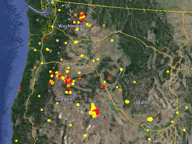
On Thursday morning more than 40 new fires had been reported in the previous 24 hours in Oregon. Almost 500,000 acres are burning in the state.
Several other large fires are burning in northern California:
Day: 4,500 acres,12 miles north of McArthur. Numerous residences are threatened and evacuations are in effect.
H-1 Bald: 3,100 acres, 9 miles northeast of Hat Creek. Residences are threatened.
White: 1,000 acres, seven miles southeast of Sawyers Bar. Residences are threatened.
Log: 130 acres, 8 miles west of Greenview.
KNF Beaver: 400 acres, 9 miles northeast of Horse Creek.
Northern California and southern Oregon fires, Friday morning, August 1, 2014. (Click to enlarge.) Oregon Gulch Fire, with another, much smaller, fire in the foreground. Photo by Joseph.
Several media outlets are reporting that a wildland firefighter died while he was off duty at a fire camp. Matthew David Goodnature, 21, of Phoenix, Oregon was found by another firefighter Tuesday evening, July 29, near Four Mile Lake on the Fremont-Winema National Forest in Oregon. Mr. Goodnature was assigned to the Launch Fire and apparently took a walk away from the camp where an accident occurred.
According to Newswatch 12:
Detective Nick Kennedy with the Klamath County Sheriff’s Office is investigating the case, and said he cannot draw any conclusions until his investigation is done. However, it appears that Goodnature tripped on a large rock and fell backwards. Scruff marks and other traces indicated Goodnature fell on a log that struck him on the small of his back. Detective Kennedy said it appears he died of a broken back.
Mr. Goodnature worked for Pacific Oasis Wildland Firefighting out of Ashland, Oregon.
We offer our sincere condolences to his family, friends,and co-workers.
Previously this year, there have been a total of six wildland firefighter fatalities: one aviation accident (plane crash) and five medical emergencies (heart attack). All six were either state or local jurisdiction employees.
Helicopter 205RH on the Bingham Complex. Photo by Richard Parish.
The photo shows helicopter 205RH inserting firefighters on the Bingham Complex on the Willamette National Forest in Oregon. The ship is operated by Hillsboro Aviation and is on contract for the Grants Pass Heli-rappellers. In the photo, pilot Joseph Berto is at the controls and the firefighters in the foreground are Mayfield, Johnson, Hastings, and England.
The Bingham Complex has burned 452 acres in and near the Mt. Jefferson Wilderness. The incident management team is calling it 55 percent controlled.
These photos of a DC-10 air tanker dropping on a fire near Twisp, Washington were no doubt taken with a telephoto lens with the aircraft on the other side of a ridge. From the vantage point of the camera it appears that the aircraft was very low, but camera angles can be deceiving. Regardless, the photos are interesting.
Two C-130s carrying Modular Airborne Firefighting Systems, which hold up to 3,000 gallons of retardant each, have been called up to help fight fires in Washington state and Oregon.
The National Oceanic and Atmosopheric Administration’s Fire Detection Map is showing smoke from Western fires blanketing most of North America. Check out the map in real time here.
To see the most current smoke reports on Wildfire Today, visit the articles tagged “smoke” at https://wildfiretoday.com/tag/smoke/
Many wildfires in Oregon and Washington state are burning out of control this week, as both states have been issued almost daily fire weather warnings. Here’s a wrap up of some of the major fires burning in both states:
Chiwaukum Creek Fire: Ignited by lightning on Tuesday, this rapidly spreading wildfire had consumed 6,630 acres by Friday morning, and forced nearly 900 residents near Leavenworth, Washington to evacuate this week. The fire forced the shutdown of several miles of U.S. Highway 2.
The fire is part of the Mills Canyon Complex, which includes the Mills Canyon Fire, burning near Entiat and now at 22,571 acres, and the Kelly Mountain Fire, also near Entiat, which has burned between 60 and 80 acres.
Meanwhile, the Carlton Complex in the Wenatchee National Forest in Washington has forced all residents of the small town of Pateros to evacuate. One of the complex’s four fires has already destroyed many homes and made a run that, by Friday morning, put the fire’s size at 260 square miles, The Associated Press reported. That’s about 167,000 acres. Reports vary as to how many homes the fire has destroyed, but the latest estimate seems to be at least 100.
All of the Carlton Complex fires were ignited by lightning on July 14: Stokes Fire, Gold Hikes Fire, French Creek Fire and the Cougar Flat fire. The Stokes Fire and the Gold Hikes fire have merged into one fire, according to Inciweb.
There are currently 14 major fires burning in Oregon. The Moccasin Hill Fire has destroyed an unknown number of homes–at last count, officials said that 33 had been destroyed. Oregon Gov. John Kitzhaber has declared a state of emergency.
When it burned through a rural southern Oregon subdivision on Sunday, the Moccasin Hill fire destroyed many more homes than fire officials initially reported.
Officials announced Wednesday that the fire destroyed 33 structures, up from the initial estimate of 20.
The Moccasin Hill fire ignited on Sunday, and prompted hundreds of people to evacuate from a rural subdivision outside of Sprague River, Eugene-based TV station KVAL reported Wednesday. As the fire spread rapidly over the weekend, officials first estimated that it destroyed six homes and 14 outbuildings.
But on Wednesday officials discovered an additional 17 destroyed homes, and some 16 destroyed outbuildings within the subdivision.
Here are some of the latest photos from the Moccasin Hill fire, which is now 35% contained. pic.twitter.com/khaDKvlbTC
The structures were all damaged on Sunday, when the fire first broke out. As of Wednesday, the fire had burned 2,500 acres. Crews have established a full containment line around the fire but are working toward the center to put out hot spots.
The cause of this fire is still under investigation.
Oregon, like much of the West Coast, has been drought-stricken for months. The U.S. Drought Monitor shows that Klamath County, the Moccasin Hill fire is burning, is almost entirely in a severe drought.
A fire 24 miles northeast of Klamath Falls, Oregon (see the map below) burned approximately 20 structures and 2,900 acres by 1 a.m. on Monday, according to reports from the National Interagency Fire Center and the South Central Oregon Fire Management Partnership. The Moccasin Hill Fire, reported at 1:15 p.m. on Sunday, has forced the evacuation of about 100 residents.
Sunday night the resources assigned to the fire included 10 engines, 3 crews, 3 dozers, 1 water tender, one single engine air tanker, five helicopters, three heavy air tankers, one very large air tanker, one lead plane and one air attack. The cause of the fire is under investigation.
Map showing the location of the Moccasin Hill Fire at 2:44 a.m. PDT, July 14, 2014. The red squares represent heat detected by a satellite. (click to see larger version)
From the Oregon Department of Forestry Sunday morning:
Yesterday’s heavy use of air retardant helped prevent the fire from spreading beyond the control lines. Sixteen loads of retardant were dropped from large air tankers and eight loads were dropped from small Single Engine Air Tankers known as SEATs. Helicopters were extremely busy all day long responding to fire fighters requests for drops on the hottest spots. Today, helicopters will continue dropping water along the southwest side of the fire.
With almost ten miles of fire line around the perimeter of this fire, fire fighters are laying hose and fittings for the next phase of holding the line and beginning mop-up on the cooler portions of the fire. The fire had slight growth due to the fire burning up to the control lines the fire fighters had established. Fire fighters continue to work diligently to stop the fire from spreading southward. A small amount of line remains to be constructed there.
They are calling it 1,327 acres and 15 percent contained.
****
(UPDATED at 7:55 a.m. PT, June 22, 2014)
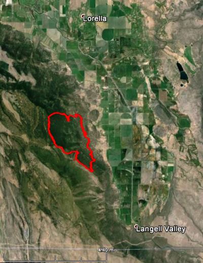
Map of the Bryant Fire. The red line was the perimeter at 9 p.m., June 21, 2014 The red line is from 24 hours earlier, on Friday night.
Very little new information is available about the Bryant Fire, burning in southern Oregon 25 miles southeast of Klamath Falls. When it was mapped Saturday night the size was estimated at about 1,260 acres.
****
(UPDATED at 7:33 a.m. PT, June 21, 2014)
3D Map of Bryant Fire, looking west at 11 pm, June 20, 2014. (click to enlarge)
The Bryant Fire south of Bonanza and southeast of Klamath Falls, Oregon was mapped at 1,300 acres late Friday night while the fire was very actively burning. It started Thursday afternoon on privately owned land in an active logging operation in felled and bucked timber on steep terrain. An Oregon Department of Forestry Type 2 incident management team assumed command Friday evening.
Map of Bryant Fire, at 11 pm, June 20, 2014. The white line near the bottom is the California/Oregon border.
****
The red and yellow squares represent heat detected on the Bryant Fire in southern Oregon by a satellite at 3:45 p.m. PT, June 20, 2014. The locations of the squares are accurate to within about a mile. (click to enlarge)
The Bryant Fire in southern Oregon was reported at 3:30 p.m. on Thursday, 10 miles south of Bonanza, 25 miles southeast of Klamath Falls, and 3 miles north of the California border. (See the map above.) Friday morning it had burned 836 acres, but there is an unofficial report Friday evening that the ODF said it has doubled to about 1,600 acres, all on privately owned land.
Oregon Department of Forestry (ODF) Incident Management Team 1, with Incident Commander John Buckman, will assume command of the fire Friday at 6 p.m.
A Type 2 State Fire Team has been ordered to take over the management of the Bryant Fire at 6 p.m. today. pic.twitter.com/kx64tWZ2Np