Christmas Red Flag Warnings in California

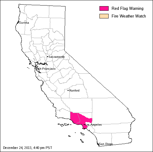
Map of Red Flag warning, California, December 24, 2013

Map of Red Flag warning, California, December 24, 2013The beautiful weather that southern Californians enjoy throughout much of the year comes with a price at times. This year their Christmas present is a Red Flag Warning for Christmas day and Thursday for areas in Ventura and Los Angeles Counties. The warm, dry, weather with breezy offshore winds will persist through Saturday.

For Christmas day and Thursday weather forecasters are predicting wind gusts of 45 to 50 mph in the mountains and gusts between 35 and 40 in wind prone valleys. Relative humidities will reach into the lower teens by late Wednesday morning and into the single digits on Thursday. These weather conditions paired with extraordinarily dry fuels will produce elevated to critical fire weather conditions.

The Red Flag Warning map was current as of 4:40 p.m. PST on Tuesday. Red Flag Warnings can change throughout the day as the National Weather Service offices around the country update and revise their forecasts.


Thanks go out to Ken

California: Red Flag Warning

wildfire Red Flag Warning, November 4, 2013

wildfire Red Flag Warning, November 4, 2013

The National Weather Service has issued a Red Flag Warning for some areas in Los Angeles and Ventura Counties in southern California for Monday evening through Tuesday night for strong northeast winds and low humidity. The wind is expected to gust up to 35 or 50 mph, depending on the area, along with a relative humidity in the low teens or single digits.

The NWS in California has started producing graphics like the one below, to inform the public about weather events like this.

Red Flag Warning graphic, November 4, 2013

More details.

The Red Flag Warning map was current as of 1:40 p.m. MDT on Monday. Red Flag Warnings can change throughout the day as the National Weather Service offices around the country update and revise their forecasts. For the most current data, visit this NWS site.


Thanks go out to Ken

Red Flag Warnings, October 4, 2013

wildfire Red Flag Warnings,  October 4, 2013

Red Flag Warnings and Fire Weather Watches for enhanced wildfire danger have been issued by the National Weather Service for areas in California, Arizona, and New Mexico.

The Red Flag Warning for southern California from Friday morning through Sunday includes the counties of Orange, southwestern San Bernardino, western Riverside, and San Diego. Winds are expected to be northeast at 20 to 30 mph with gusts to 60 mph with isolated gusts to 75 mph, along with single-digit relative humidities.

The Red Flag Warning map was current as of 1:30 p.m. MDT on Friday. Red Flag Warnings can change throughout the day as the National Weather Service offices around the country update and revise their forecasts. For the most current data, visit this NWS site.

Red Flag Warnings, October 3, 2013 — during the government shutdown

wildfire Red Flag Warnings, October 3, 2013

wildfire Red Flag Warnings, October 3, 2013

Red Flag Warnings and Fire Weather Watches for enhanced wildfire danger have been issued by the National Weather Service for areas in California, Arizona, Kansas, and New Mexico. Click the map above to see a larger version.

In light of the Red Flag Warnings, the diminished number of firefighters even before the partial shutdown is something to keep an eye on. According to Leo Kay, the Director of Communication for the U.S. Forest Service, “80 to 90 percent of the agency’s firefighting resources are available” in the wake of the decision by the dysfunctional Congress to shut down much of the government. We asked if those resources are currently working, as opposed to being furloughed but on 2-hour call like some National Park Service firefighters, and he said yes, explaining that they are “excepted employees” during the shutdown.

Firefighters that are still working are telling us that they are not being paid and there is no way to accurately predict WHEN they will receive a pay check.

The Red Flag Warning for the San Bernardino area of southern California predicts a “moderate strength” Santa Ana wind for late Thursday night through Sunday, with northeast to east winds sustained at 25 to 40 mph with local gusts as high as 65 mph through and below canyons and passes. The winds will peak Friday night and Saturday.

The Red Flag Warning map was current as of 7:30 a.m. MDT on Thursday. Red Flag Warnings can change throughout the day as the National Weather Service offices around the country update and revise their forecasts. For the most current data, visit this NWS site.

Red Flag Warnings, October 2, 2103

wildfire Red Flag Warnings, October 2, 2013Apparently the National Weather Service forecasters who designate Red Flag Warning areas have not been furloughed like many federal firefighters were.

Red Flag Warnings and Fire Weather Watches for enhanced wildfire danger have been issued by the National Weather Service for areas in California, Arizona, Nevada, and New Mexico. Click the map above to see a larger version.

The Red Flag Warning map was current as of 10:28 a.m. MDT on Wednesday. Red Flag Warnings can change throughout the day as the National Weather Service offices around the country update and revise their forecasts. For the most current data, visit this NWS site.

Red Flag Warnings and Smoke Map, August 22, 2013

Wildfire smoke, at 9:40 a.m. MDT, August 22, 2013

wildfire Red Flag Warnings, August 22, 2013

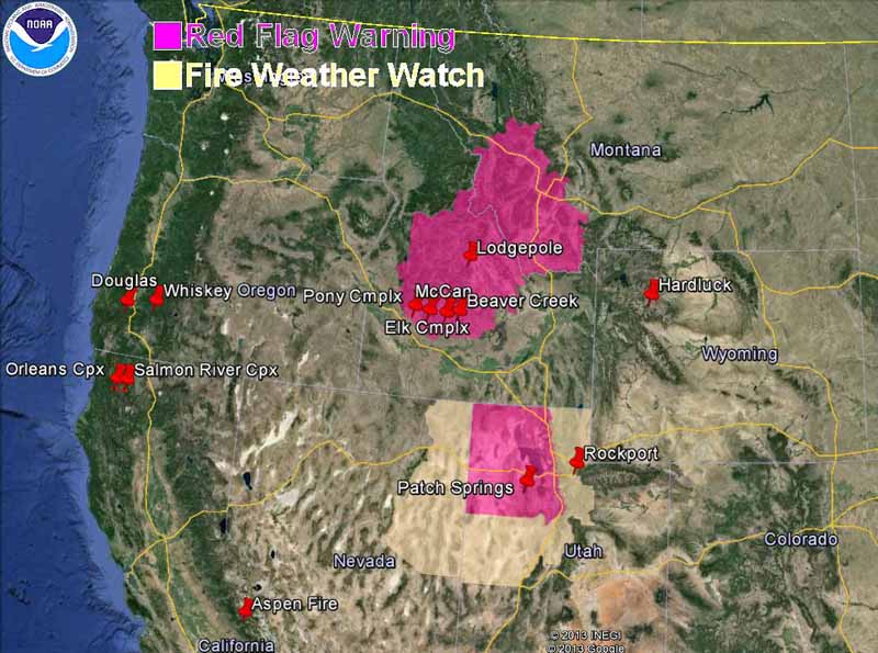
Red Flag Warnings and Fire Weather Watches for enhanced wildfire danger have been issued by the National Weather Service for areas in Idaho, California, Washington, Montana and Oregon. Click the map above to see a larger version.

The Red Flag Warning map was current as of 9 a.m. MDT on Thursday. Red Flag Warnings can change throughout the day as the National Weather Service offices around the country update and revise their forecasts. For the most current data, visit this NWS site.

The map below shows the distribution of wildfire smoke in the United States at 9:40 a.m. MDT August 22, 2013.

Wildfire smoke, at 9:40 a.m. MDT, August 22, 2013


Red Flag Warnings and smoke map, August 20, 2013

wildfire Red Flag Warnings, August 20, 2013

Red Flag Warnings and Fire Weather Watches for enhanced wildfire danger have been issued by the National Weather Service for areas in Idaho, California, and Oregon.

The Red Flag Warning map above was current as of 7:20 a.m. MDT on Tuesday. Red Flag Warnings can change throughout the day as the National Weather Service offices around the country update and revise their forecasts. For the most current data, visit this NWS site.

The maps below shows the distribution of wildfire smoke in the United States at 5:20 a.m. MDT August 20, 2013.

Wildfire smoke, at 5:20 a.m. MDT, August 20, 2013
Wildfire smoke
Wildfire smoke, dense levels only, at 5:20 a.m. MDT, August 20, 2013

Red Flag Warnings and smoke map, August 19, 2013

wildfire Red Flag Warnings, August 19, 2013

wildfire Red Flag Warnings, August 19, 2013

Red Flag Warnings and Fire Weather Watches for enhanced wildfire danger have been issued by the National Weather Service for areas in Idaho, Montana, California, and Oregon. Dry lightning is in the forecast on Monday for northern California.

****

The Red Flag Warning map above was current as of 9:40 a.m. MDT on Monday. Red Flag Warnings can change throughout the day as the National Weather Service offices around the country update and revise their forecasts. For the most current data, visit this NWS site.

The map below shows the distribution of wildfire smoke in the United States at 11:04 a.m. MDT August 19, 2013.

Wildfire smoke, at 11:04 a.m. MDT, August 19, 2013

Below is the map of the northwest U.S. from Sunday, showing only dense smoke.

Wildfire smoke, August 18, 2013
Wildfire smoke, August 18, 2013, showing only the dense smoke.

Smoke map and Red Flag Warnings, August 18, 2013

Wildfire smoke, at 10:23 a.m. MDT, August 18, 2013

The map above shows the distribution of smoke from wildfires in the United States at 10:23 a.m. MDT today.

wildfire Red Flag Warnings, August 18, 2013
The map shows Red Flag Warnings, Fire Weather Watches, and some of the more active fires in the United States. (click to enlarge)

Red Flag Warnings and Fire Weather Watches for enhanced wildfire danger have been issued by the National Weather Service for areas in Idaho, Oregon, and California.

****

The Red Flag Warning map above was current as of 11 a.m. MDT on Sunday. Red Flag Warnings can change throughout the day as the National Weather Service offices around the country update and revise their forecasts. For the most current data, visit this NWS site.

Red Flag Warnings and Smoke Map, August 16, 2013

wildfire Red Flag Warnings, August 16, 2013
map of Wildfire smoke, at 2:13 p.m. MDT, August 16, 2013
Wildfire smoke, at 2:13 p.m. MDT, August 16, 2013

The map above shows the distribution of smoke from wildfires in the United States at 2:13 p.m. MDT, August 16, 2013. (UPDATE: Darren Clabo provided this link to a satellite animation that shows the smoke early Friday morning.)

wildfire Red Flag Warnings, August 16, 2013

Red Flag Warnings and Fire Weather Watches for enhanced wildfire danger have been issued by the National Weather Service for areas in Idaho, Montana, Nevada, and Utah.

****

The Red Flag Warning map above was current as of 8:20 a.m. MDT on Friday. Red Flag Warnings can change throughout the day as the National Weather Service offices around the country update and revise their forecasts. For the most current data, visit this NWS site.